
ឯកសារ:1686 Mallet Map of Ceylon or Sri Lanka (Taprobane) - Geographicus - Taprobane-mallet-1686.jpg

ទំហំរបស់ការមើលមុននេះ: ៤៧២ × ៥៩៩ ភីកសែ។ ភាពម៉ត់ផ្សេងទៀត៖ ១៨៩ × ២៤០ ភីកសែ | ៣៧៨ × ៤៨០ ភីកសែ | ៦០៥ × ៧៦៨ ភីកសែ | ៨០៧ × ១០២៤ ភីកសែ | ១៦០២ × ២០៣៣ ភីកសែ។
រូបភាពដើម (១៦០២ × ២០៣៣ ភីកសែល ទំហំឯកសារ៖ ១មេកាបៃ ប្រភេទ MIME៖ image/jpeg)
_-_Geographicus_-_Taprobane-mallet-1686.jpg)
| Ancienne Isle Taprobane. Die alte Insel Tabrobane. | ||||||
|---|---|---|---|---|---|---|
| វិចិត្រករ | ||||||
| ចំណងជើង |
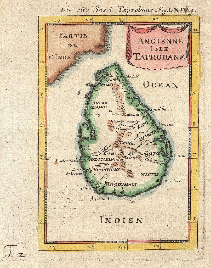
Ancienne Isle Taprobane. Die alte Insel Tabrobane. |
|||||
| ការពិពណ៌នា |
English: A beautiful miniature 1683 map of Ceylon, Sri Lanka, or Taprobane by Alain Mallet. This stunning little map covers the island of Ceylon as well as parts of adjacent India. Mallet first introduced this map in the 1683 though it was republished several time in the subsequent 20 years. Taprobane is an ancient name for a spice rich trading center that was well known in ancient Roman times. By the 17th century Portuguese explorers had reopened the route to the Indies but were uncertain exactly which island the Romans were referring to. Some map Taprobrane as Sumatra, other as Ceylon. The common consensus now, as in Mallet’s time, is that the Roman Taprobane is Ceylon. Published by copper plate in the 1686 Frankfurt edition of Mallet’s Description de l'Univers. |
|||||
| កាលបរិច្ឆេទ | ១៦៨៦ (undated) | |||||
| វិមាត្រ | height: ៧.០ in (១៧.៧ cm); width: ៥.០ in (១២.៧ cm) | |||||
| អត្តលេខ |
Geographicus link: Taprobane-mallet-1686 |
|||||
| ប្រភព/ជាងថតរូប |
Mallet, A., Description de l'Univers, (Frankfurt), 1686.
|
|||||
| ការអនុញ្ញាត (ប្រើឯកសារនេះឡើងវិញ) |
|
|||||
ប្រវត្តិឯកសារ
ចុចលើម៉ោងនិងកាលបរិច្ឆេទដើម្បីមើលឯកសារដែលបានផ្ទុកឡើងនៅពេលនោះ។
| ម៉ោងនិងកាលបរិច្ឆេទ | កូនរូបភាព | វិមាត្រ | អ្នកប្រើប្រាស់ | យោបល់ | |
|---|---|---|---|---|---|
| បច្ចុប្បន្ន | ម៉ោង២២:១៧ ថ្ងៃព្រហស្បតិ៍ ទី២៤ ខែមីនា ឆ្នាំ២០១១ | | ១៦០២ × ២០៣៣ (១មេកាបៃ) | BotMultichillT | {{subst:User:Multichill/Geographicus |link=http://www.geographicus.com/P/AntiqueMap/Taprobane-mallet-1686 |product_name=1686 Mallet Map of Ceylon or Sri Lanka (Taprobane) |map_title=Ancienne Isle Taprobane. Die alte Insel Tabrobane. |description=A beautif |
បម្រើបម្រាស់ឯកសារ
ទំព័រ ខាងក្រោមប្រើប្រាស់ឯកសារនេះ ៖
បម្រើបម្រាស់ឯកសារជាសាកល
វីគីដទៃទៀតដូចខាងក្រោមនេះប្រើប្រាស់ឯកសារនេះ៖
- ការប្រើប្រាស់នៅក្នុង ar.wikipedia.org
- ការប្រើប្រាស់នៅក្នុង ckb.wikipedia.org
- ការប្រើប្រាស់នៅក្នុង en.wikipedia.org
- History of Sri Lanka
- Mahāvaṃsa
- Beminitiya Seya
- Cūḷavaṃsa
- Sri Lankan independence movement
- Dīpavaṃsa
- Template:History of Sri Lanka
- Capital of Sri Lanka
- Prehistory of Sri Lanka
- User:Blackknight12/List of historical Sri Lankan overseas military operations
- British Ceylon period
- History of Sri Lanka (1948–present)
- Anuradhapura period
- Chola conquest of Anuradhapura
- User:༆/History of Asia templates
- User:Blackknight12/sandbox
- List of wars involving Sri Lanka
- Pre-Anuradhapura period
- Polonnaruwa period
- Transitional period of Sri Lanka
- Rajavaliya
- Kandyan period
- Crisis of the Sixteenth Century
- Template:History of Sri Lanka/doc
- Malay invasions of Sri Lanka
- Cartography of Sri Lanka
- User:Lesa2006/sandbox
- ការប្រើប្រាស់នៅក្នុង fa.wikipedia.org
- ការប្រើប្រាស់នៅក្នុង fi.wikipedia.org
- ការប្រើប្រាស់នៅក្នុង fr.wikipedia.org
- ការប្រើប្រាស់នៅក្នុង ja.wikipedia.org
- ការប្រើប្រាស់នៅក្នុង ko.wikipedia.org
View more global usage of this file.
_-_Geographicus_-_Taprobane-mallet-1686.jpg)
_-_Geographicus_-_Taprobane-mallet-1686.jpg)