
ឯកសារ:Afghanistan politisch 1996.png
ទំហំរបស់ការមើលមុននេះ: ៧៦៨ × ៦០០ ភីកសែ។ ភាពម៉ត់ផ្សេងទៀត៖ ៣០៧ × ២៤០ ភីកសែ | ៦១៥ × ៤៨០ ភីកសែ | ៩៨៣ × ៧៦៨ ភីកសែ | ១២៨០ × ១០០០ ភីកសែ | ២០៧៩ × ១៦២៤ ភីកសែ។
រូបភាពដើម (២០៧៩ × ១៦២៤ ភីកសែល ទំហំឯកសារ៖ ២.២៥មេកាបៃ ប្រភេទ MIME៖ image/png)
ចំណារពន្យល់
| ការពិពណ៌នា |
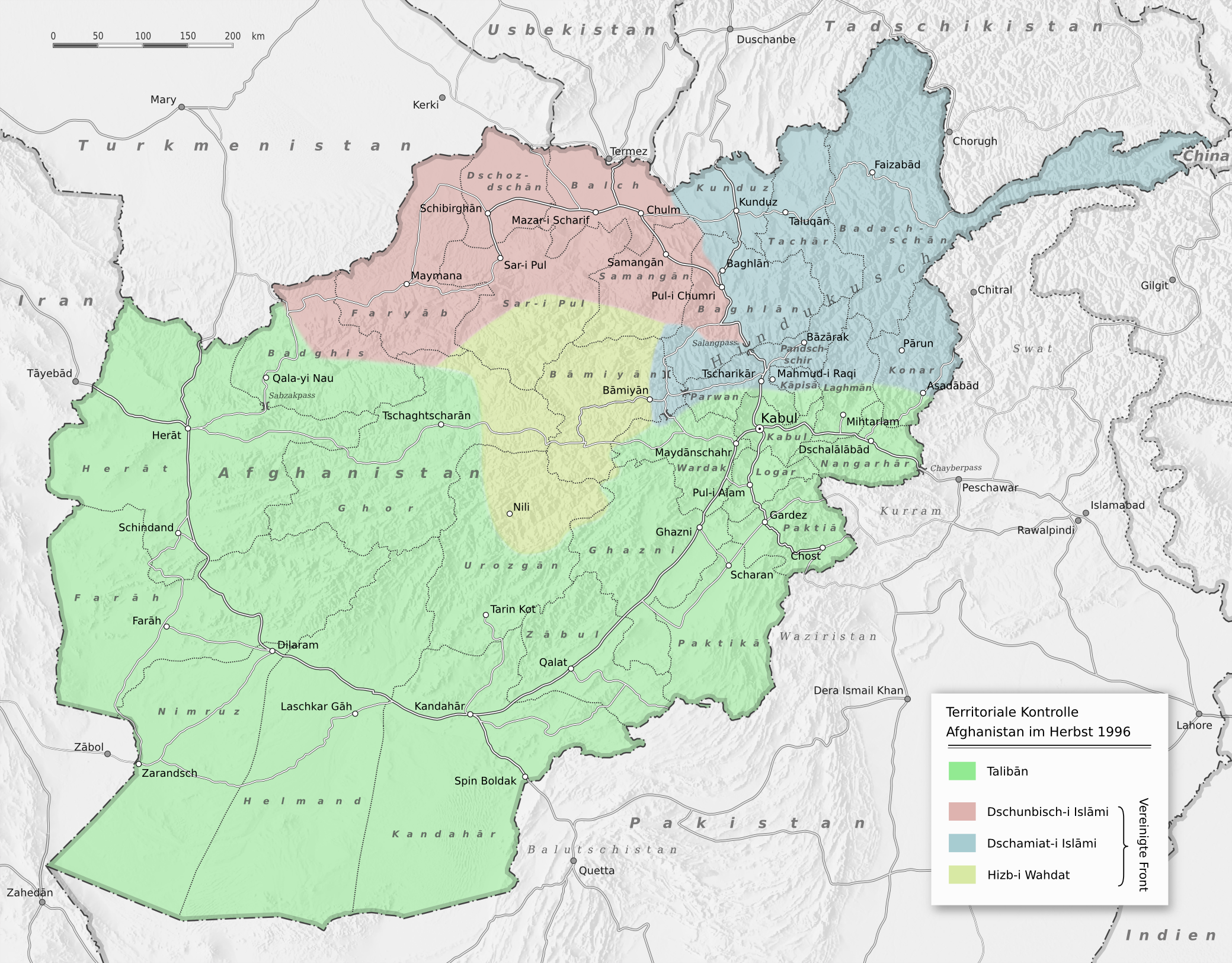
Deutsch: Vereinfachte Darstellung der territorialen Kontrolle Afghanistans im Herbst 1996 nach der Eroberung Kabuls durch die Talibanbewegung
English: Territorial control in Afghanistan in the fall of 1996, after the capture of Kabul by the Taliban. |
| កាលបរិច្ឆេទ | |
| ប្រភព |
Transferred from de.wikipedia to Commons by NordNordWest using CommonsHelper.
Schummerung basiert auf:
|
| អ្នកនិពន្ធ | Benutzer:Sommerkom |
ការដាក់អាជ្ញាប័ណ្ណ
ឯកសារនេះជាប់អាជ្ញាបណ្ឌCreative Commons Attribution-Share Alike 3.0 Germany។
- អ្នកមានសិទ្ធិ៖
- ចែកចាយ – ថតចំលងនិងចែកចាយស្នាដៃនេះ
- កែច្នៃ – កែច្នៃយកទៅប្រើ
- ក្រោមលក្ខខណ្ឌដូចតទៅនេះ៖
- ភាពជាម្ចាស់កម្មសិទ្ធ – You must give appropriate credit, provide a link to the license, and indicate if changes were made. You may do so in any reasonable manner, but not in any way that suggests the licensor endorses you or your use.
- share alike – If you remix, transform, or build upon the material, you must distribute your contributions under the same or compatible license as the original.

Original upload log
The original description page was here. All following user names refer to de.wikipedia.
- 2010-09-10 09:45 Sommerkom 2079×1624× (3087010 bytes) {{Information |Beschreibung = Vereinfachte Darstellung der territorialen Kontrolle Afghanistans im Herbst 1996 nach der Eroberung Kabuls durch die Talibanbewegung |Quelle = Territoriale Kontrolle nach: * [[Gilles Dorronsoro]]: ''Revolution Unending: Afghanistan, 1979 to the Present'', Columbia University Press, New York 2005, {{ISBN|978-0-231-13626-6}}, S.248 Schummerung basiert auf: * topographischer Datensatz [http://www2.jpl.nasa.gov/srtm/index.html SRTM30 V2.1] |Urheber = [[Benutzer:Sommerkom]] |Datum = 7.09.2010 |Genehmigung = |Andere Versionen = |Anmerkungen = }} == [[Wikipedia:Lizenzvorlagen für Bilder|Lizenz]]: == {{Bild-CC-by-sa/3.0/de}}
ប្រវត្តិឯកសារ
ចុចលើម៉ោងនិងកាលបរិច្ឆេទដើម្បីមើលឯកសារដែលបានផ្ទុកឡើងនៅពេលនោះ។
| ម៉ោងនិងកាលបរិច្ឆេទ | កូនរូបភាព | វិមាត្រ | អ្នកប្រើប្រាស់ | យោបល់ | |
|---|---|---|---|---|---|
| បច្ចុប្បន្ន | ម៉ោង២១:៥៦ ថ្ងៃសៅរ៍ ទី២៨ ខែសីហា ឆ្នាំ២០២១ | | ២០៧៩ × ១៦២៤ (២.២៥មេកាបៃ) | Jul059 | Lossless file size reduction |
| ម៉ោង២០:០៣ ថ្ងៃព្រហស្បតិ៍ ទី១៦ ខែកញ្ញា ឆ្នាំ២០១០ |  | ២០៧៩ × ១៦២៤ (២.៩៤មេកាបៃ) | File Upload Bot (Magnus Manske) | {{BotMoveToCommons|de.wikipedia|year={{subst:CURRENTYEAR}}|month={{subst:CURRENTMONTHNAME}}|day={{subst:CURRENTDAY}}}} {{Information |Description={{de|Vereinfachte Darstellung der territorialen Kontrolle Afghanistans im Herbst 1996 nach der Eroberung Kab |
បម្រើបម្រាស់ឯកសារ
ទំព័រ ខាងក្រោមប្រើប្រាស់ឯកសារនេះ ៖
បម្រើបម្រាស់ឯកសារជាសាកល
វីគីដទៃទៀតដូចខាងក្រោមនេះប្រើប្រាស់ឯកសារនេះ៖
- ការប្រើប្រាស់នៅក្នុង ar.wikipedia.org
- ការប្រើប្រាស់នៅក្នុង azb.wikipedia.org
- ការប្រើប្រាស់នៅក្នុង be.wikipedia.org
- ការប្រើប្រាស់នៅក្នុង de.wikipedia.org
- ការប្រើប្រាស់នៅក្នុង el.wikipedia.org
- ការប្រើប្រាស់នៅក្នុង en.wikipedia.org
- ការប្រើប្រាស់នៅក្នុង es.wikipedia.org
- ការប្រើប្រាស់នៅក្នុង fa.wikipedia.org
- ការប្រើប្រាស់នៅក្នុង it.wikipedia.org
- ការប្រើប្រាស់នៅក្នុង ja.wikipedia.org
- ការប្រើប្រាស់នៅក្នុង nl.wikipedia.org
- ការប្រើប្រាស់នៅក្នុង pap.wikipedia.org
- ការប្រើប្រាស់នៅក្នុង simple.wikipedia.org
- ការប្រើប្រាស់នៅក្នុង sw.wikipedia.org
- ការប្រើប្រាស់នៅក្នុង tr.wikipedia.org
- ការប្រើប្រាស់នៅក្នុង uk.wikipedia.org
- ការប្រើប្រាស់នៅក្នុង uz.wikipedia.org
- ការប្រើប្រាស់នៅក្នុង vi.wikipedia.org