
ឯកសារ:Costa Rica relief location map.jpg

ទំហំរបស់ការមើលមុននេះ: ៦៦៦ × ៦០០ ភីកសែ។ ភាពម៉ត់ផ្សេងទៀត៖ ២៦៧ × ២៤០ ភីកសែ | ៥៣៣ × ៤៨០ ភីកសែ | ៨៥៣ × ៧៦៨ ភីកសែ | ១១៤៨ × ១០៣៤ ភីកសែ។
រូបភាពដើម (១១៤៨ × ១០៣៤ ភីកសែល ទំហំឯកសារ៖ ៨៤១គីឡូបៃ ប្រភេទ MIME៖ image/jpeg)
ចំណារពន្យល់
| ទីតាំងម៉ាស៊ីនថត | | រូបភាពនេះនិងរូបភាពផ្សេងទៀតនៅឯទីតាំងរបស់វាលើ: OpenStreetMap |
|---|
| ការពិពណ៌នា |
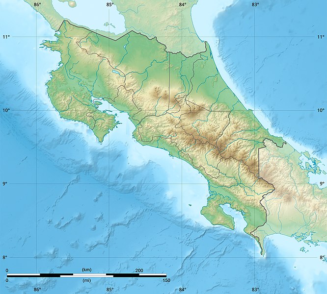
English: Blank relief map of Costa Rica for geo-location purpose.
Note : The Isla del Coco, out of the map, is not shown. Scale : 1:1,856,000 (accuracy : 464 m) Français : Carte du relief vierge du Costa Rica destinée à la géolocalisation.
Note : L´Isla del Coco, hors carte, n'est pas représentée. Échelle : 1:1 856 000 (précision : 464 m) Equirectangular projection centered on 9° 30' N – 84° 15' W, WGS84 datum * West : 86° 30' W * East : 82° W * North : 11° 30' N * South : 7° 30' N |
||
| កាលបរិច្ឆេទ | 2008-06, updated 2022-03 | ||
| ប្រភព |
ការងារផ្ទាល់របស់អ្នកផ្ទុកឡើង
|
||
| អ្នកនិពន្ធ | Eric Gaba (Sting - fr:Sting) | ||
| ការអនុញ្ញាត (ប្រើឯកសារនេះឡើងវិញ) |
|
||
| ទំរង់ផ្សេងទៀត |
|

ការដាក់អាជ្ញាប័ណ្ណ
Eric Gaba (user Sting) for Wikimedia Commons using GEBCO_2021 Grid data, the copyright holder of this work, hereby publishes it under the following licenses:

|
រូបភាពនៃទំព័រនេះជាកម្មសិទ្ធិរបស់GNU Free Documentation License។ Version 1.2 ឬក៏ខ្ពស់ជាងនេះត្រូវបានឧបត្ថមគាំទ្រដោយ មូលនិធិសូហ្វវែរដោយឥតគិតថ្លៃ (Free Software Foundation) ដែលមិនមានផ្នែកណាមួយរបស់ប្រភពដើមរួមទាំងអក្សរនៅលើគំរបមុខនិងខ្នង ត្រូវបានផ្លាស់ប្តូរទេ។ ចំពោះផ្នែកដែលមិនអាចផ្លាស់ប្តូរបាន សូមមើលGNU Free Documentation License។ |
This file is licensed under the Creative Commons Attribution-Share Alike Attribution-Share Alike 4.0 International, 3.0 Unported, 2.5 Generic, 2.0 Generic and 1.0 Generic license.
ភាពជាម្ចាស់កម្មសិទ្ធ: Eric Gaba (user Sting) for Wikimedia Commons using GEBCO_2021 Grid data
- អ្នកមានសិទ្ធិ៖
- ចែកចាយ – ថតចំលងនិងចែកចាយស្នាដៃនេះ
- កែច្នៃ – កែច្នៃយកទៅប្រើ
- ក្រោមលក្ខខណ្ឌដូចតទៅនេះ៖
- ភាពជាម្ចាស់កម្មសិទ្ធ – You must give appropriate credit, provide a link to the license, and indicate if changes were made. You may do so in any reasonable manner, but not in any way that suggests the licensor endorses you or your use.
- share alike – If you remix, transform, or build upon the material, you must distribute your contributions under the same or compatible license as the original.
You may select the license of your choice.
ប្រវត្តិឯកសារ
ចុចលើម៉ោងនិងកាលបរិច្ឆេទដើម្បីមើលឯកសារដែលបានផ្ទុកឡើងនៅពេលនោះ។
| ម៉ោងនិងកាលបរិច្ឆេទ | កូនរូបភាព | វិមាត្រ | អ្នកប្រើប្រាស់ | យោបល់ | |
|---|---|---|---|---|---|
| បច្ចុប្បន្ន | ម៉ោង២២:៥១ ថ្ងៃពុធ ទី៣០ ខែមីនា ឆ្នាំ២០២២ | | ១១៤៨ × ១០៣៤ (៨៤១គីឡូបៃ) | Sting | New map using new data |
| ម៉ោង០១:៣២ ថ្ងៃព្រហស្បតិ៍ ទី០៤ ខែវិច្ឆិកា ឆ្នាំ២០២១ |  | ១១៤៨ × ១០៣៤ (៩០៦គីឡូបៃ) | RoboQwezt0x7CB | hand edited to remove non-existing waterbodies, used lower elevation green shade to bucket fill (best I can do without the tools to generate the map) particulary in the south of the country (probably an altitude render/clipping error), kept some that are hydroelectric plant's reservoirs | |
| ម៉ោង១២:១១ ថ្ងៃច័ន្ទ ទី១៩ ខែកក្កដា ឆ្នាំ២០១០ |  | ១១៤៨ × ១០៣៤ (៥០០គីឡូបៃ) | Sting | Color profile | |
| ម៉ោង១៥:០៥ ថ្ងៃពុធ ទី៣០ ខែកក្កដា ឆ្នាំ២០០៨ |  | ១១៤៨ × ១០៣៤ (៤៩១គីឡូបៃ) | Sting | - border | |
| ម៉ោង១៤:៤០ ថ្ងៃសុក្រ ទី១៣ ខែមិថុនា ឆ្នាំ២០០៨ |  | ១១៤៨ × ១០៣៤ (៤៩៩គីឡូបៃ) | Sting | Several improvements | |
| ម៉ោង០១:២១ ថ្ងៃព្រហស្បតិ៍ ទី១២ ខែមិថុនា ឆ្នាំ២០០៨ |  | ១១៤៨ × ១០៣៤ (៥០១គីឡូបៃ) | Sting | Correction on shaded layer | |
| ម៉ោង០១:០៩ ថ្ងៃព្រហស្បតិ៍ ទី១២ ខែមិថុនា ឆ្នាំ២០០៨ |  | ១១៤៨ × ១០៣៤ (៥០៤គីឡូបៃ) | Sting | == Summary == {{Location|10|00|00|N|84|00|00|W|scale:2000000}} <br/> {{Information |Description={{en|Blank relief map of Costa Rica for geo-location purpose.<br/>''Note :'' The ''Isla del Coco'', out of the map, is not shown.<br/>Scale |
បម្រើបម្រាស់ឯកសារ
ទំព័រ ខាងក្រោមប្រើប្រាស់ឯកសារនេះ ៖
បម្រើបម្រាស់ឯកសារជាសាកល
វីគីដទៃទៀតដូចខាងក្រោមនេះប្រើប្រាស់ឯកសារនេះ៖
- ការប្រើប្រាស់នៅក្នុង ar.wikipedia.org
- ការប្រើប្រាស់នៅក្នុង ast.wikipedia.org
- ការប្រើប្រាស់នៅក្នុង azb.wikipedia.org
- ការប្រើប្រាស់នៅក្នុង az.wikipedia.org
- ការប្រើប្រាស់នៅក្នុង ban.wikipedia.org
- ការប្រើប្រាស់នៅក្នុង ba.wikipedia.org
- ការប្រើប្រាស់នៅក្នុង be.wikipedia.org
- ការប្រើប្រាស់នៅក្នុង bg.wikipedia.org
- ការប្រើប្រាស់នៅក្នុង bn.wikipedia.org
- ការប្រើប្រាស់នៅក្នុង bs.wikipedia.org
- ការប្រើប្រាស់នៅក្នុង ca.wikipedia.org
- ការប្រើប្រាស់នៅក្នុង ceb.wikipedia.org
- ការប្រើប្រាស់នៅក្នុង ce.wikipedia.org
- ការប្រើប្រាស់នៅក្នុង ckb.wikipedia.org
- ការប្រើប្រាស់នៅក្នុង cs.wikipedia.org
View more global usage of this file.