
ឯកសារ:Europe 1812 map en.png

ទំហំរបស់ការមើលមុននេះ: ៨០០ × ៥២៦ ភីកសែ។ ភាពម៉ត់ផ្សេងទៀត៖ ៣២០ × ២១១ ភីកសែ | ៦៤០ × ៤២១ ភីកសែ | ១០២៤ × ៦៧៤ ភីកសែ | ១២៨០ × ៨៤២ ភីកសែ | ២២៨៤ × ១៥០៣ ភីកសែ។
រូបភាពដើម (២២៨៤ × ១៥០៣ ភីកសែល ទំហំឯកសារ៖ ១.១៤មេកាបៃ ប្រភេទ MIME៖ image/png)
ចំណារពន្យល់

|
រូបភាព historical mapនេះ គួរតែបង្កើតឡើងវិញដោយប្រើក្រាភិកវ៉ិចទ័រ ដែលជាប្រភេទហ្វាល់ SVG ។ ការបង្កើតរូបភាពជាហ្វាល់ SVG ផ្តល់នូវអត្ថប្រយោជន៍ជាច្រើន។ ចំពោះព័ត៌មានបន្ថែម សូមមើល Commons:Media for cleanup ។ ប្រសិនបើទំរង់ SVG នៃរូបភាពនេះត្រូវបានបង្កើតរួចរាល់ហើយ សូមអាប់ឡូដវា។ បន្ទាប់ពីអាប់ឡូដជាទំរង់ SVG សូមជំនួសទំព័រគំរូនេះដោយ {{vector version available|ឈ្មោះរូបភាពថ្មី.svg}} ។
|
| ការពិពណ៌នា |
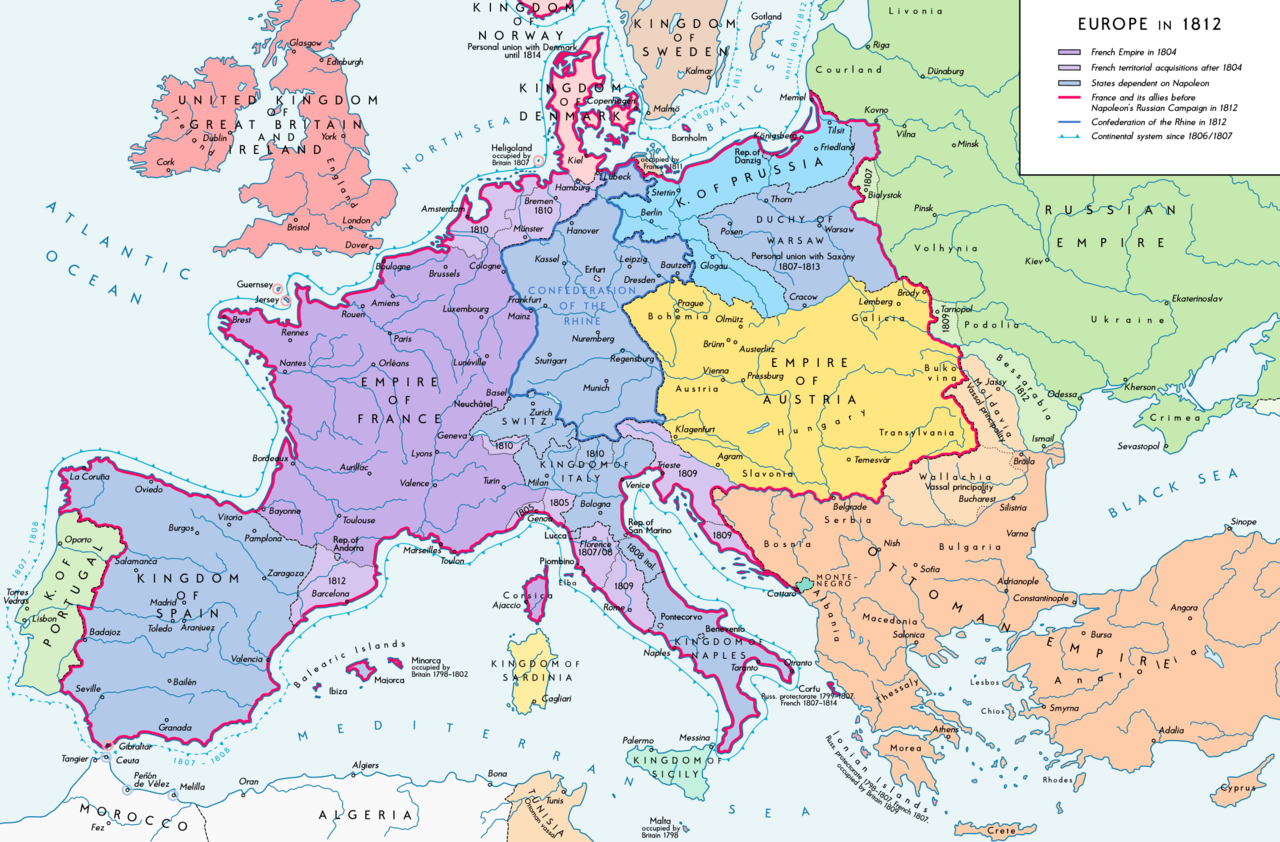
Deutsch: Europa 1812. Politische Ausgangslage vor Napeoleons Russlandfelzug. English: Europe in 1812. Political situation before Napoleon's Russian Campaign. |
| កាលបរិច្ឆេទ | |
| ប្រភព |
ការងារផ្ទាល់របស់អ្នកផ្ទុកឡើង. Source of Information: – Map "L'apogée de l'Empire Français (avant la campagne de Russie)" (Author unknown)(Link) – Dr. Walter Leiserung (ed.): Historischer Weltatlas, Marix Verlag, Wiesbaden 2004, ISBN 978-3-937715-59-9 – Zentralinstitut für Geschichte der Akademie der Wissenschaften der DDR (ed.): Atlas zur Geschichte, Band 1, VEB Hermann Haack, Gotha 1989, ISBN 3-7301-0040-8 – Prof. Dr. Vadim Oswalt, Prof. Dr. Hans Ulrich Rudolf (ed.): Klett-Perthes Atlas zur Weltgeschichte, Ernst Klett Verlag, Stuttgart 2011, ISBN 978-3-12-828194-0 – Ferenc Majoros u. Bernd Rill: Das Osmanische Reich 1300-1922. Die Geschichte einer Großmacht, Lzenzausgabe für Weltbild Verlag, Augsburg 2000, ISBN 3-8289-0336-3 |
| អ្នកនិពន្ធ | Alexander Altenhof |
| ទំរង់ផ្សេងទៀត |
|


_en.png)
.png)
.jpg)
ការដាក់អាជ្ញាប័ណ្ណ
I, the copyright holder of this work, hereby publish it under the following license:
ឯកសារនេះជាប់អាជ្ញាបណ្ឌCreative Commons Attribution-Share Alike 3.0 Unported។
- អ្នកមានសិទ្ធិ៖
- ចែកចាយ – ថតចំលងនិងចែកចាយស្នាដៃនេះ
- កែច្នៃ – កែច្នៃយកទៅប្រើ
- ក្រោមលក្ខខណ្ឌដូចតទៅនេះ៖
- ភាពជាម្ចាស់កម្មសិទ្ធ – You must give appropriate credit, provide a link to the license, and indicate if changes were made. You may do so in any reasonable manner, but not in any way that suggests the licensor endorses you or your use.
- share alike – If you remix, transform, or build upon the material, you must distribute your contributions under the same or compatible license as the original.
ប្រវត្តិឯកសារ
ចុចលើម៉ោងនិងកាលបរិច្ឆេទដើម្បីមើលឯកសារដែលបានផ្ទុកឡើងនៅពេលនោះ។
| ម៉ោងនិងកាលបរិច្ឆេទ | កូនរូបភាព | វិមាត្រ | អ្នកប្រើប្រាស់ | យោបល់ | |
|---|---|---|---|---|---|
| បច្ចុប្បន្ន | ម៉ោង១៥:២៦ ថ្ងៃអាទិត្យ ទី១១ ខែកញ្ញា ឆ្នាំ២០១៦ | | ២២៨៤ × ១៥០៣ (១.១៤មេកាបៃ) | KaterBegemot | Border corrections at Thorn and Tarnopol area, minor kerning and positioning changes |
| ម៉ោង០០:៤៧ ថ្ងៃពុធ ទី២០ ខែកក្កដា ឆ្នាំ២០១៦ |  | ២២៨៤ × ១៥០៣ (១.១៤មេកាបៃ) | KaterBegemot | Added Bukovina / Corrected spelling of Sevastopol, Courland, Belgrade, Duchy of Warsaw / Marked Corfu as territory under French influence (red) / Correct position of city points of Basel, Geneva, Toulouse / Minor border corrections / Better kerning / T... | |
| ម៉ោង០០:២១ ថ្ងៃព្រហស្បតិ៍ ទី១៤ ខែកក្កដា ឆ្នាំ២០១៦ |  | ២២៨៤ × ១៥០៣ (១.១៤មេកាបៃ) | KaterBegemot | Added P. of Neuchatel, Ekaterinoslav, Varna, Brăila / Corrected borders of Montenegro, Milan-Genoa area | |
| ម៉ោង០០:៤៣ ថ្ងៃព្រហស្បតិ៍ ទី០៣ ខែធ្នូ ឆ្នាំ២០១៥ |  | ២២៨៤ × ១៥០៣ (១.០៩មេកាបៃ) | Ras67 | frame cropped | |
| ម៉ោង១១:៣១ ថ្ងៃអាទិត្យ ទី២៩ ខែវិច្ឆិកា ឆ្នាំ២០១៥ |  | ២២៩៣ × ១៥១២ (១.១២មេកាបៃ) | Spiridon Ion Cepleanu | Some details & corrections in the Austrian & Ottoman empires, according with « Grosser Atlas zur Weltgeschichte » (H.E.Stier, dir.) Westermann 1985, ISBN 3-14-100919-8, « Putzger historischer Weltatlas Cornelsen » 1990, ISBN 3-464-00176-8, « Atlas... | |
| ម៉ោង២១:៤៧ ថ្ងៃសៅរ៍ ទី០៥ ខែតុលា ឆ្នាំ២០១៣ |  | ២២៩៣ × ១៥១២ (១.០១មេកាបៃ) | KaterBegemot | Corrected boundaries of Switzerland, Prussia and Circassia | |
| ម៉ោង២៣:៥៣ ថ្ងៃសៅរ៍ ទី១៥ ខែកញ្ញា ឆ្នាំ២០១២ |  | ២២៩៣ × ១៥១២ (១.០១មេកាបៃ) | KaterBegemot | == {{int:filedesc}} == {{Information |Description= {{de|1=Europa 1812. Politische Ausgangslage vor Napeoleons Russlandfelzug.}}{{en|1=Europe in 1812. Political situation before Napoleon's Russian Campaign.}} |Source={{Own}}. Source of Information: </br... |
បម្រើបម្រាស់ឯកសារ
ទំព័រ ខាងក្រោមប្រើប្រាស់ឯកសារនេះ ៖
បម្រើបម្រាស់ឯកសារជាសាកល
វីគីដទៃទៀតដូចខាងក្រោមនេះប្រើប្រាស់ឯកសារនេះ៖
- ការប្រើប្រាស់នៅក្នុង af.wikipedia.org
- ការប្រើប្រាស់នៅក្នុង azb.wikipedia.org
- ការប្រើប្រាស់នៅក្នុង br.wikipedia.org
- ការប្រើប្រាស់នៅក្នុង ca.wikipedia.org
- ការប្រើប្រាស់នៅក្នុង ce.wikipedia.org
- ការប្រើប្រាស់នៅក្នុង cs.wikipedia.org
- ការប្រើប្រាស់នៅក្នុង da.wikipedia.org
- ការប្រើប្រាស់នៅក្នុង de.wikipedia.org
- ការប្រើប្រាស់នៅក្នុង el.wikipedia.org
- ការប្រើប្រាស់នៅក្នុង en.wikipedia.org
- History of Austria
- Napoleonic Wars
- Puppet state
- Napoleon
- Client state
- Klemens von Metternich
- France in the long nineteenth century
- Ideas of European unity before 1948
- Principality of Erfurt
- First French Empire
- Territorial evolution of France
- French invasion of Russia
- Alexander I of Russia
- Wikipedia talk:GLAM/Israel Museum, Jerusalem
- French period
- History of French foreign relations
- List of French client states
- International relations (1648–1814)
- Conference of Dresden (1812)
- User:Falcaorib
- ការប្រើប្រាស់នៅក្នុង en.wikibooks.org
- ការប្រើប្រាស់នៅក្នុង eo.wikipedia.org
- ការប្រើប្រាស់នៅក្នុង es.wikipedia.org
- ការប្រើប្រាស់នៅក្នុង fi.wikipedia.org
- ការប្រើប្រាស់នៅក្នុង fr.wikipedia.org
- ការប្រើប្រាស់នៅក្នុង fy.wikipedia.org
- ការប្រើប្រាស់នៅក្នុង hr.wikipedia.org
View more global usage of this file.