
ឯកសារ:Galapagos Islands topographic map-en.svg

Size of this PNG preview of this SVG file: ៦០០ × ៦០០ ភីកសែ. ភាពម៉ត់ផ្សេងទៀត៖ ២៤០ × ២៤០ ភីកសែ | ៤៨០ × ៤៨០ ភីកសែ | ៧៦៨ × ៧៦៨ ភីកសែ | ១០២៤ × ១០២៤ ភីកសែ | ២០៤៨ × ២០៤៨ ភីកសែ | ២១៦០ × ២១៦០ ភីកសែ។
រូបភាពដើម (ឯកសារប្រភេទSVG ២១៦០ × ២១៦០ ភីកសែល ទំហំឯកសារ៖ ២.៦២មេកាបៃ)
ចំណារពន្យល់
| ការពិពណ៌នា |
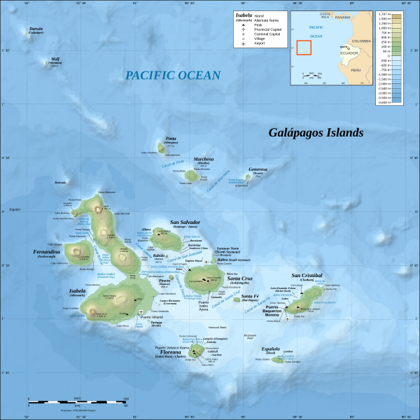
*The background map is a raster image embedded in the SVG file. *UTM projection, WGS84 datum *Scales: **Topography: 1:800,000 (accuracy: 200m) **Bathymetry: 1:4,000,000 (accuracy: 1,000m) |
| កាលបរិច្ឆេទ | (UTC) |
| ប្រភព | |
| អ្នកនិពន្ធ |
|
| ទំរង់ផ្សេងទៀត |
[]
|

.png)


| This is a retouched picture, which means that it has been digitally altered from its original version. Modifications: Translated from German into English. The original can be viewed here: Galapagos Islands topographic map-de.svg. Modifications made by MatthewStevens.
|
I, the copyright holder of this work, hereby publish it under the following licenses:
ឯកសារនេះជាប់អាជ្ញាបណ្ឌCreative Commons Attribution-Share Alike 3.0 Unported, 2.5 Generic, 2.0 Generic និង 1.0 Generic។
- អ្នកមានសិទ្ធិ៖
- ចែកចាយ – ថតចំលងនិងចែកចាយស្នាដៃនេះ
- កែច្នៃ – កែច្នៃយកទៅប្រើ
- ក្រោមលក្ខខណ្ឌដូចតទៅនេះ៖
- ភាពជាម្ចាស់កម្មសិទ្ធ – You must give appropriate credit, provide a link to the license, and indicate if changes were made. You may do so in any reasonable manner, but not in any way that suggests the licensor endorses you or your use.
- share alike – If you remix, transform, or build upon the material, you must distribute your contributions under the same or compatible license as the original.

|
រូបភាពនៃទំព័រនេះជាកម្មសិទ្ធិរបស់GNU Free Documentation License។ Version 1.2 ឬក៏ខ្ពស់ជាងនេះត្រូវបានឧបត្ថមគាំទ្រដោយ មូលនិធិសូហ្វវែរដោយឥតគិតថ្លៃ (Free Software Foundation) ដែលមិនមានផ្នែកណាមួយរបស់ប្រភពដើមរួមទាំងអក្សរនៅលើគំរបមុខនិងខ្នង ត្រូវបានផ្លាស់ប្តូរទេ។ ចំពោះផ្នែកដែលមិនអាចផ្លាស់ប្តូរបាន សូមមើលGNU Free Documentation License។ |
You may select the license of your choice.
Original upload log
This image is a derivative work of the following images:
- File:Galapagos_Islands_topographic_map-de.svg licensed with Cc-by-sa-3.0,2.5,2.0,1.0, GFDL
- 2008-11-03T19:33:06Z NordNordWest 2160x2160 (2744048 Bytes) corrected
- 2008-10-26T17:07:45Z NordNordWest 2160x2160 (2746684 Bytes) {{Location|00|30|00|S|90|30|00|W|scale:1000000}} {{Information |Description= {{de|Topografische and bathymetrische Karte der [[:de:Galápagos-Inseln|Galápagos-Inseln]], [[:de:Ecuador|Ecuador]].}} {{en|Topographic and bathyme
Uploaded with derivativeFX
ប្រវត្តិឯកសារ
ចុចលើម៉ោងនិងកាលបរិច្ឆេទដើម្បីមើលឯកសារដែលបានផ្ទុកឡើងនៅពេលនោះ។
| ម៉ោងនិងកាលបរិច្ឆេទ | កូនរូបភាព | វិមាត្រ | អ្នកប្រើប្រាស់ | យោបល់ | |
|---|---|---|---|---|---|
| បច្ចុប្បន្ន | ម៉ោង១១:៤០ ថ្ងៃអង្គារ ទី០៤ ខែតុលា ឆ្នាំ២០១៦ | | ២១៦០ × ២១៦០ (២.៦២មេកាបៃ) | Teofilo | <s>Marlborough</s> → Narborough |
| ម៉ោង០០:១៥ ថ្ងៃសុក្រ ទី០២ ខែកញ្ញា ឆ្នាំ២០១១ |  | ២១៦០ × ២១៦០ (២.៦២មេកាបៃ) | MatthewStevens | {{Information |Description={{de|Topografische and bathymetrische Karte der Galápagos-Inseln, Ecuador.}} {{en|Topographic and bathymetric map of the Galápagos Islands, [[:en:Ecuador|Ecu |
បម្រើបម្រាស់ឯកសារ
ទំព័រ ខាងក្រោមប្រើប្រាស់ឯកសារនេះ ៖
បម្រើបម្រាស់ឯកសារជាសាកល
វីគីដទៃទៀតដូចខាងក្រោមនេះប្រើប្រាស់ឯកសារនេះ៖
- ការប្រើប្រាស់នៅក្នុង azb.wikipedia.org
- ការប្រើប្រាស់នៅក្នុង bg.wikipedia.org
- ការប្រើប្រាស់នៅក្នុង br.wikipedia.org
- ការប្រើប្រាស់នៅក្នុង da.wikipedia.org
- ការប្រើប្រាស់នៅក្នុង en.wikipedia.org
- ការប្រើប្រាស់នៅក្នុង en.wikiversity.org
- ការប្រើប្រាស់នៅក្នុង es.wikipedia.org
- ការប្រើប្រាស់នៅក្នុង fa.wikipedia.org
- ការប្រើប្រាស់នៅក្នុង fy.wikipedia.org
- ការប្រើប្រាស់នៅក្នុង gl.wikipedia.org
- ការប្រើប្រាស់នៅក្នុង hy.wikipedia.org
- ការប្រើប្រាស់នៅក្នុង id.wikipedia.org
- ការប្រើប្រាស់នៅក្នុង is.wikipedia.org
- ការប្រើប្រាស់នៅក្នុង it.wikipedia.org
- ការប្រើប្រាស់នៅក្នុង mi.wikipedia.org
- ការប្រើប្រាស់នៅក្នុង mr.wikipedia.org
- ការប្រើប្រាស់នៅក្នុង ms.wikipedia.org
- ការប្រើប្រាស់នៅក្នុង my.wikipedia.org
- ការប្រើប្រាស់នៅក្នុង nds-nl.wikipedia.org
- ការប្រើប្រាស់នៅក្នុង nl.wikipedia.org
- ការប្រើប្រាស់នៅក្នុង no.wikipedia.org
- ការប្រើប្រាស់នៅក្នុង pl.wikipedia.org
- ការប្រើប្រាស់នៅក្នុង pt.wikipedia.org
View more global usage of this file.