
ឯកសារ:Karte des Deutschen Reiches, Weimarer Republik-Drittes Reich 1919–1937.svg

Size of this PNG preview of this SVG file: ៦៦០ × ៦០០ ភីកសែ. ភាពម៉ត់ផ្សេងទៀត៖ ២៦៤ × ២៤០ ភីកសែ | ៥២៨ × ៤៨០ ភីកសែ | ៨៤៥ × ៧៦៨ ភីកសែ | ១១២៧ × ១០២៤ ភីកសែ | ២២៥៤ × ២០៤៨ ភីកសែ | ៩៧៤ × ៨៨៥ ភីកសែ។
រូបភាពដើម (ឯកសារប្រភេទSVG ៩៧៤ × ៨៨៥ ភីកសែល ទំហំឯកសារ៖ ១.៧មេកាបៃ)
ចំណារពន្យល់
| ការពិពណ៌នា |
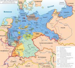
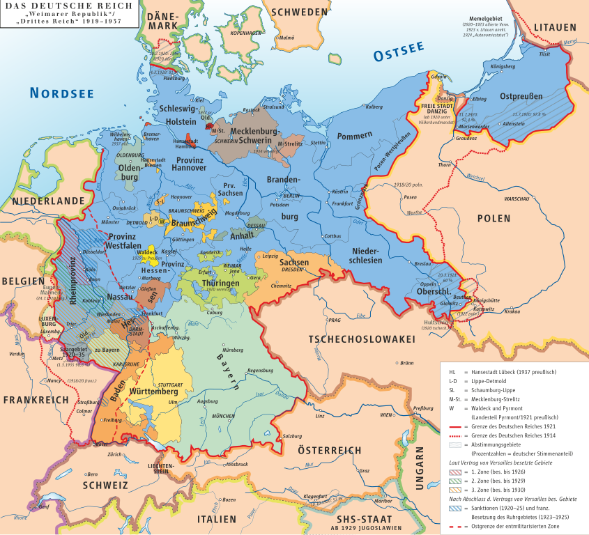
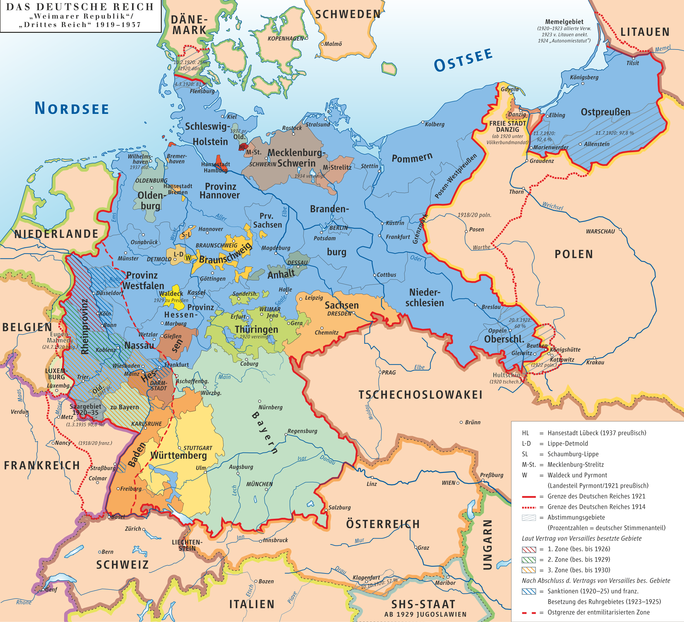
Deutsch: Karte des Deutschen Reiches, »Weimarer Republik/Drittes Reich« 1919–1937 English: Map of the German Reich, (Republic of Weimar/Third Reich) 1919–1937 |
| កាលបរិច្ឆេទ | |
| ប្រភព | own drawing/Source of Information: Putzger – Historischer Weltatlas, 89. Auflage, 1965 |
| អ្នកនិពន្ធ | kgberger |
| ការអនុញ្ញាត (ប្រើឯកសារនេះឡើងវិញ) |
GNU FDL |
| SVG genesis | រូបភាពក្រាភិកវ៉ិចទ័រនេះត្រូវបានបង្កើតឡើងដោយប្រើ Inkscape. |
ការដាក់អាជ្ញាប័ណ្ណ
I, the copyright holder of this work, hereby publish it under the following licenses:

|
រូបភាពនៃទំព័រនេះជាកម្មសិទ្ធិរបស់GNU Free Documentation License។ Version 1.2 ឬក៏ខ្ពស់ជាងនេះត្រូវបានឧបត្ថមគាំទ្រដោយ មូលនិធិសូហ្វវែរដោយឥតគិតថ្លៃ (Free Software Foundation) ដែលមិនមានផ្នែកណាមួយរបស់ប្រភពដើមរួមទាំងអក្សរនៅលើគំរបមុខនិងខ្នង ត្រូវបានផ្លាស់ប្តូរទេ។ ចំពោះផ្នែកដែលមិនអាចផ្លាស់ប្តូរបាន សូមមើលGNU Free Documentation License។ |
| ឯកសារនេះជាប់អាជ្ញាបណ្ឌCreative Commons Attribution-Share Alike 3.0 Unported។ | ||
| ||
| This licensing tag was added to this file as part of the GFDL licensing update. |
ឯកសារនេះជាប់អាជ្ញាបណ្ឌCreative Commons Attribution 2.5 Generic។
- អ្នកមានសិទ្ធិ៖
- ចែកចាយ – ថតចំលងនិងចែកចាយស្នាដៃនេះ
- កែច្នៃ – កែច្នៃយកទៅប្រើ
- ក្រោមលក្ខខណ្ឌដូចតទៅនេះ៖
- ភាពជាម្ចាស់កម្មសិទ្ធ – You must give appropriate credit, provide a link to the license, and indicate if changes were made. You may do so in any reasonable manner, but not in any way that suggests the licensor endorses you or your use.
You may select the license of your choice.
ប្រវត្តិឯកសារ
ចុចលើម៉ោងនិងកាលបរិច្ឆេទដើម្បីមើលឯកសារដែលបានផ្ទុកឡើងនៅពេលនោះ។
| ម៉ោងនិងកាលបរិច្ឆេទ | កូនរូបភាព | វិមាត្រ | អ្នកប្រើប្រាស់ | យោបល់ | |
|---|---|---|---|---|---|
| បច្ចុប្បន្ន | ម៉ោង២០:១៧ ថ្ងៃសៅរ៍ ទី២១ ខែមករា ឆ្នាំ២០២៣ | | ៩៧៤ × ៨៨៥ (១.៧មេកាបៃ) | Felicior | move Freiburg further to the east |
| ម៉ោង១១:២២ ថ្ងៃអាទិត្យ ទី១៣ ខែធ្នូ ឆ្នាំ២០២០ |  | ៩៧៤ × ៨៨៥ (១.៤៥មេកាបៃ) | Intforce | Reduce SVG file size | |
| ម៉ោង១២:៣០ ថ្ងៃពុធ ទី០៩ ខែមករា ឆ្នាំ២០១៣ |  | ៩៧៤ × ៨៨៥ (២.០៦មេកាបៃ) | Ziegelbrenner | 2013-01-09 | |
| ម៉ោង១៦:៣៤ ថ្ងៃអង្គារ ទី២៧ ខែកក្កដា ឆ្នាំ២០១០ |  | ៧៧៥ × ៧៧៥ (១.០៧មេកាបៃ) | Beao | Tweak. | |
| ម៉ោង១៦:៣១ ថ្ងៃអង្គារ ទី២៧ ខែកក្កដា ឆ្នាំ២០១០ |  | ៧៧៩ × ៧៨២ (១.០៧មេកាបៃ) | Beao | Removed border. | |
| ម៉ោង១៦:៣៧ ថ្ងៃសុក្រ ទី០៧ ខែវិច្ឆិកា ឆ្នាំ២០០៨ |  | ៧៨២ × ៧៨៤ (១០០២គីឡូបៃ) | Ahellwig | test | |
| ម៉ោង១៦:២៤ ថ្ងៃសុក្រ ទី០៧ ខែវិច្ឆិកា ឆ្នាំ២០០៨ | គ្មានកូនរូបភាព | (១០០៣គីឡូបៃ) | ChrisiPK | Reverted to version as of 12:35, 18 January 2008: new version seems to be broken | |
| ម៉ោង១២:៣៧ ថ្ងៃសុក្រ ទី១៨ ខែមករា ឆ្នាំ២០០៨ | គ្មានកូនរូបភាព | (១០០៣គីឡូបៃ) | Ziegelbrenner | == Beschreibung == {{Information |Description=Karte des Deutschen Reiches, »Weimarer Republik/Drittes Reich« 1919–1937 / Map of German Reich, »Republic of Weimar/Third Reich« 1919–1937 |Source=own drawing/Source of Information: Putzger – Histori | |
| ម៉ោង១២:៣៥ ថ្ងៃសុក្រ ទី១៨ ខែមករា ឆ្នាំ២០០៨ | គ្មានកូនរូបភាព | (១០០៣គីឡូបៃ) | Ziegelbrenner | == Beschreibung == {{Information |Description=Karte des Deutschen Reiches, »Weimarer Republik/Drittes Reich« 1919–1937 / Map of German Reich, »Republic of Weimar/Third Reich« 1919–1937 |Source=own drawing/Source of Information: Putzger – Histori |
បម្រើបម្រាស់ឯកសារ
ទំព័រ ខាងក្រោមប្រើប្រាស់ឯកសារនេះ ៖
បម្រើបម្រាស់ឯកសារជាសាកល
វីគីដទៃទៀតដូចខាងក្រោមនេះប្រើប្រាស់ឯកសារនេះ៖
- ការប្រើប្រាស់នៅក្នុង af.wikipedia.org
- ការប្រើប្រាស់នៅក្នុង als.wikipedia.org
- ការប្រើប្រាស់នៅក្នុង an.wikipedia.org
- ការប្រើប្រាស់នៅក្នុង ar.wikipedia.org
- تورينغن
- ولاية بريمن
- بافاريا
- ساكسونيا
- بروسيا
- جمهورية فايمار
- جمهورية عنق الزجاجة
- قالب:ولايات جمهورية فايمار
- ولاية بروسيا الحرة
- بوابة:بافاريا
- بوابة:بافاريا/قوالب
- ولاية أنهالت الحرة
- الرايخ الرابع
- مستخدم:Marksman003/قائمة بشعارات النبالة في ألمانيا
- قائمة الولايات التاريخية الألمانية
- التقسيمات الإدارية في ألمانيا النازية
- جمهورية بافاريا السوفيتية
- ولاية بافاريا الشعبية
- ការប្រើប្រាស់នៅក្នុង ast.wikipedia.org
- ការប្រើប្រាស់នៅក្នុង azb.wikipedia.org
- ការប្រើប្រាស់នៅក្នុង ba.wikipedia.org
- ការប្រើប្រាស់នៅក្នុង be-tarask.wikipedia.org
- ការប្រើប្រាស់នៅក្នុង be.wikipedia.org
- ការប្រើប្រាស់នៅក្នុង bg.wikipedia.org
- ការប្រើប្រាស់នៅក្នុង bn.wikipedia.org
- ការប្រើប្រាស់នៅក្នុង bs.wikipedia.org
- ការប្រើប្រាស់នៅក្នុង ca.wikipedia.org
- ការប្រើប្រាស់នៅក្នុង cs.wikipedia.org
- ការប្រើប្រាស់នៅក្នុង da.wikipedia.org
- ការប្រើប្រាស់នៅក្នុង de.wikipedia.org
View more global usage of this file.