
ឯកសារ:Location map Malaysia Peninsula.png

ទំហំរបស់ការមើលមុននេះ: ៥៥៧ × ៥៩៩ ភីកសែ។ ភាពម៉ត់ផ្សេងទៀត៖ ២២៣ × ២៤០ ភីកសែ | ៤៤៦ × ៤៨០ ភីកសែ | ៨៨៤ × ៩៥១ ភីកសែ។
រូបភាពដើម (៨៨៤ × ៩៥១ ភីកសែល ទំហំឯកសារ៖ ២១៨គីឡូបៃ ប្រភេទ MIME៖ image/png)
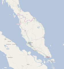
| ការពិពណ៌នា |
English: Map of Peninsula Malaysia
Geographic limits of the map:
ឯកសារនេះជាប់អាជ្ញាបណ្ឌCreative Commons Attribution-Share Alike 2.0 Generic។
|
| ប្រភព | OpenStreetMap |
| អ្នកនិពន្ធ | Dr. Blofeld |
ប្រវត្តិឯកសារ
ចុចលើម៉ោងនិងកាលបរិច្ឆេទដើម្បីមើលឯកសារដែលបានផ្ទុកឡើងនៅពេលនោះ។
| ម៉ោងនិងកាលបរិច្ឆេទ | កូនរូបភាព | វិមាត្រ | អ្នកប្រើប្រាស់ | យោបល់ | |
|---|---|---|---|---|---|
| បច្ចុប្បន្ន | ម៉ោង២២:៥៧ ថ្ងៃសៅរ៍ ទី០៥ ខែមីនា ឆ្នាំ២០១១ | | ៨៨៤ × ៩៥១ (២១៨គីឡូបៃ) | Blofeld Dr. | {{Information |Description ={{en|1=e}} |Source =r |Author =r |Date =r |Permission = |other_versions = }} |
បម្រើបម្រាស់ឯកសារ
2 ទំព័រ ខាងក្រោមប្រើប្រាស់ឯកសារនេះ ៖
បម្រើបម្រាស់ឯកសារជាសាកល
វីគីដទៃទៀតដូចខាងក្រោមនេះប្រើប្រាស់ឯកសារនេះ៖
- ការប្រើប្រាស់នៅក្នុង ace.wikipedia.org
- ការប្រើប្រាស់នៅក្នុង ar.wikipedia.org
- ការប្រើប្រាស់នៅក្នុង ceb.wikipedia.org
- ការប្រើប្រាស់នៅក្នុង en.wikipedia.org
- ការប្រើប្រាស់នៅក្នុង fa.wikipedia.org
- ការប្រើប្រាស់នៅក្នុង hu.wikipedia.org
- ការប្រើប្រាស់នៅក្នុង id.wikipedia.org
- ការប្រើប្រាស់នៅក្នុង kn.wikipedia.org
- ការប្រើប្រាស់នៅក្នុង min.wikipedia.org
- ការប្រើប្រាស់នៅក្នុង ml.wikipedia.org
- ការប្រើប្រាស់នៅក្នុង ms.wikipedia.org
- ការប្រើប្រាស់នៅក្នុង or.wikipedia.org
- ការប្រើប្រាស់នៅក្នុង tr.wikipedia.org
- ការប្រើប្រាស់នៅក្នុង uk.wikipedia.org
- ការប្រើប្រាស់នៅក្នុង ur.wikipedia.org
- ការប្រើប្រាស់នៅក្នុង vi.wikipedia.org
- ការប្រើប្រាស់នៅក្នុង war.wikipedia.org