
ប្រទេសនៅអាមេរិកខាងត្បូង
.svg)
អត្ថបទនេះគឺស្តីអំពី បញ្ជីរាយនាមរដ្ឋអធិបតេយ្យ និងរដ្ឋអនិស្សរភាពនៅអាមេរិកខាងត្បូង។ នៅក្នុងអត្ថបទនេះដែរ យើងបានរាប់បញ្ចូលទាំងរដ្ឋដែលមានការទទួលស្គាល់ពេញលេញនិងរដ្ឋអនិស្សរភាព (មិនមានឯករាជ្យពេញលេញ) ដែលមានទីតាំងស្ថិតនៅទ្វីបអាមេរិកខាងត្បូង។
អាមេរិកខាងត្បូងមានព្រំប្រទល់៖ ខាងលិចជាប់នឹងមហាសមុទ្រប៉ាស៊ីហ្វិក ខាងជើងនិងខាងកើតជាប់នឹងមហាសមុទ្រអាត្លង់ទិក ហើយខាងទិសពាយព្យគឺជាប់នឹងទ្វីបអាមេរិកខាងជើងនិងសមុទ្រការ៉ាប៊ីន។ អាមេរិកខាងត្បូងគឺមានផ្ទៃដីសរុបប្រមាណ ១៧,៨៤០,០០០ គីឡូម៉ែត្រការ៉េ ដែលស្មើនឹង ៣.៥% នៃផ្ទៃផែនដី។ នៅឆ្នាំ២០០៨ សៀវភៅហេតុការណ៍ពិភពលោកបានធ្វើការប៉ាន់ស្មានចំនួនប្រជាជននៅអាមេរិកខាងត្បូងថាមានចំនួនប្រមាណ ៣៨០ លាននាក់។ អាមេរិកខាងត្បូងគឺជាប់ចំណាត់ថ្នាក់លេខ ៤ ខាងចំនួនផ្ទៃដីនៃទ្វីប (នៅពីក្រោយអាស៊ី អាហ្រ្វិក និងអាមេរិកខាងជើង) ហើយជាប់ចំណាត់ថ្នាក់លេខ ៥ ខាងចំនួនប្រជាជន (នៅពីក្រោយអាស៊ី អាហ្រ្វិក អឺរ៉ុប និងអាមេរិកខាងជើង។[១]
ព្រំដែនបែងចែកទ្វីបអាមេរិកខាងត្បូងពីទ្វីបអាមេរិកខាងជើងគឺមិនទាន់មានច្បាស់លាស់នោះទេ តែបច្ចុប្បន្ន គេបានចាត់ទុកថាដីព្រែកប៉ាណាម៉ាគឺជាខ្សែព្រំដែនដែលបំបែកទ្វីបទាំងពីរ។
រដ្ឋអធិបតេយ្យ[កែប្រែ]
រដ្ឋអធិបតេយ្យដែលមានទឹកដីធំៗគ្របដណ្តប់លើផ្ទៃដីទ្វីបអាមេរិកខាងត្បូង[កែប្រែ]
រដ្ឋអធិបតេយ្យគឺជាសមាគមនយោបាយមួយដែលមានអធិបតេយ្យភាពលើប្រជាជនខ្លួន ហើយអ្នកទាំងនោះត្រូវធ្វើការសម្រេចចិត្តដើម្បីបំពេញនូវផលប្រយោជន៍នៃប្រទេសជាតិ។[២] យោងទៅតាមអនុសញ្ញាម៉ុងតេវីដេអូបានឱ្យដឹងថា៖ រដ្ឋនីមួយៗត្រូវតែមានប្រជាជនជានិរន្ត មានទឹកដីកំណត់ច្បាស់លាស់ មានរដ្ឋាភិបាលដឹកនាំសមរម្យ និងមានសមត្ថភាពក្នុងការធ្វើទំនាក់ទំនងជាមួយនឹងរដ្ឋដទៃទៀត។[៣] រដ្ឋខាងក្រោមនេះគឺសុទ្ធតែជាសមាជិកនៃអង្គការសហប្រជាជាតិ[៤] និងជាសមាជិកនៃសហភាពប្រជាជាតិអាមេរិកខាងត្បូង។[៥]
| ទង់ជាតិ | ផែនទី | នាមទូទៅ/នាមផ្លូវការ និងកូដ ISO[៦][៧][៨] | នាមជាភាសាក្នុងស្រុក [៦][៧] |
រដ្ឋធានី [៨][៩][១០] |
ចំនួនប្រជាជន [១១] |
ក្រឡាផ្ទៃសរុប [១២] |
|---|---|---|---|---|---|---|
 |
 |
កូឡុំប៊ី សាធារណរដ្ឋកូឡុំប៊ី COL |
ភាសាអេស្ប៉ាញ៖ Colombia — República de Colombia | បូគោតា / សានតា ហ្វេ ដេ បូគោតា | ៥១,០៩៦,៣៨៦ | ១,១៣៨,៩១០ គីឡូម៉ែត្រការ៉េ |
 |
 |
គុយយ៉ាន សាធារណរដ្ឋសហករណ៍គុយយ៉ាន GUY |
ភាសាអង់គ្លេស៖ Guyana — Co-operative Republic of Guyana | ចចថោន | ៧៨៦,៩២៣ | ២១៤,៩៦៩ គីឡូម៉ែត្រការ៉េ |
 |
 |
ឈីលី [n ១] សាធារណរដ្ឋឈីលី CHL |
ភាសាអេស្ប៉ាញ៖ Chile — República de Chile | សង់ចាកូ[n ២] | ១៩,២០០,២៦៨ | ៧៥៦,១០២ គីឡូម៉ែត្រការ៉េ |
 |
 |
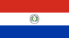
ប៉ារ៉ាគ្វេ សាធារណរដ្ឋប៉ារ៉ាគ្វេ PRY |
ភាសាអេស្ប៉ាញ៖ Paraguay — República del Paraguay ភាសាក្វារ៉ានី៖ Paraguai — Tetã Paraguai |
អាសង់ស្យុង | ៧,១៤៣,៣៦៦ | ៤០៦,៧៥២ គីឡូម៉ែត្រការ៉េ |
 |
 |
ប៉េរូ សាធារណរដ្ឋប៉េរូ PER |
ភាសាអេស្ប៉ាញ៖ Perú — República del Perú ភាសាកេជូវ៉ា៖ Piruw — Piruw Republika ភាសាអៃម៉ារ៉ា៖ Piruw — Piruw Suyu |
លីម៉ា | ៣៣,០៩៣,៥៧៨ | ១,២៨៥,២១៦ គីឡូម៉ែត្រការ៉េ |
 |
 |
បូលីវី រដ្ឋពហុជនជាតិបូលីវី BOL |
ភាសាអេស្ប៉ាញ៖ Bolivia — Estado Plurinacional de Bolivia ភាសាកេជូវ៉ា៖ Buliwya — Puliwya Mamallaqta ភាសាអៃម៉ារ៉ា៖ Wuliwya – Wuliwya Suyu |
ស៊ុយក្រ (រដ្ឋធានីផ្លូវការ) និងឡាប៉ាស (អាសនៈរដ្ឋាភិបាល)[n ៣] |
១១,៦៩១,៦៥៨ | ១,០៩៨,៥៨១ គីឡូម៉ែត្រការ៉េ |
 |
 |
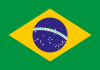
ប្រេស៊ីល សាធារណរដ្ឋសហព័ន្ធប្រេស៊ីល BRA |
ភាសាព័រទុយកាល់៖ Brasil — República Federativa do Brasil | ប្រាស៊ីលីយ៉ា | ២១២,៨០១,៥២៣ | ៨,៥១៤,៨៧៧ គីឡូម៉ែត្រការ៉េ |
 |
 |
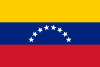
វេណេស៊ុយអេឡា សាធារណរដ្ឋបូលីវ៉ានៃវេណេស៊ុយអេឡា VEN |
ភាសាអេស្ប៉ាញ៖ Venezuela — República Bolivariana de Venezuela | ការ៉ាកាស | ២៨,១១២,៩២១ | ៩១២,០៥០ គីឡូម៉ែត្រការ៉េ |
 |
 |
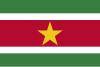
ស៊ូរីណាម សាធារណរដ្ឋស៊ូរីណាម SUR |
ភាសាហុល្លង់៖ Suriname — Republiek Suriname | ប៉ារ៉ាម៉ារីបូ | ៥៨៧,៣៥០ | ១៦៨,៨២០ គីឡូម៉ែត្រការ៉េ |
 |
 |
អ៊ូរុយគ្វេ សាធារណរដ្ឋបូព៌ាអ៊ូរុយគ្វេ URY |
ភាសាអេស្ប៉ាញ៖ Uruguay — República Oriental del Uruguay | ម៉ុងតេវីដេអូ | ៣,៤៧៥,៤៨០ | ១៧៦,២១៥ គីឡូម៉ែត្រការ៉េ |
 |
 |
អាហ្សង់ទីន សាធារណរដ្ឋអាហ្សង់ទីន ARG |
ភាសាអេស្ប៉ាញ៖ Argentina — República Argentina | ប៊ុយណូស៊ែ ភាសាអេស្ប៉ាញ៖ Ciudad de Buenos Aires |
៤៥,២៤៦,៧៤១ | ២,៧៨០,៥០០ គីឡូម៉ែត្រការ៉េ |
 |
 |
អេក្វាទ័រ សាធារណរដ្ឋអេក្វាទ័រ ECU |
ភាសាអេស្ប៉ាញ៖ Ecuador — República del Ecuador ភាសាកេជូវ៉ា៖ Ikwadur |
គីតូ | ១៧,៦៩៧,៥៥៨ | ២៨៣,៥៦១ គីឡូម៉ែត្រការ៉េ |
ទឹកដីក្រៅប្រទេសនៃរដ្ឋអធិបតេយ្យដែលស្ថិតនៅលើទ្វីបអាមេរិកខាងត្បូង[កែប្រែ]
| ទង់ជាតិ | ផែនទី | នាមជាភាសាខ្មែរ និងកូដ ISO[៦][៨] | ស្ថានភាព | នាមក្នុងស្រុក | រដ្ឋធានី[៩] | ចំនួនប្រជាជន[១១] | ក្រឡាផ្ទៃ[១២] |
|---|---|---|---|---|---|---|---|
 |
.svg) |
គុយយ៉ានបារាំង GUF |
គុយយ៉ានបារាំង, នាយកដ្ឋាន និងតំបន់ក្រៅស្រុករបស់ប្រទេសបារាំង | គុយយ៉ាន ភាសាបារាំង៖ Guyane |
កាយេន ភាសាបារាំង៖ Cayenne |
២៩៦,៧១១ [១៣] | ៨៣,៥៣៤ គីឡូម៉ែត្រការ៉េ |
ទឹកដីអនិស្សរភាព[កែប្រែ]
| ទង់ជាតិ | ផែនទី | នាមជាភាសាខ្មែរ[៦][៨] | ស្ថានភាព | នាមក្នុងស្រុក | រាជធានី[៩] | ចំនួនប្រជាជន[១១] | ក្រឡាផ្ទៃ[១២] |
|---|---|---|---|---|---|---|---|
 |
 |
កោះចចជីខាងត្បូង និងសាំងវិចខាងត្បូង[n ៤] | ទឹកដីក្រៅស្រុករបស់អង់គ្លេស | អង់គ្លេស: South Georgia and the South Sandwich Islands | ចំណុចក្សត្រអែដវើដ អង់គ្លេស: King Edward Point |
គ្មានប្រជាជនអចិន្រ្តៃយ៍[n ៥] | ៣,៩០៣ គីឡូម៉ែត្រការ៉េ |
 |
.svg) |
ប្រជុំកោះហ្វកឡិន FLK |
ទឹកដីក្រៅស្រុករបស់អង់គ្លេស | អង់គ្លេស: Falkland Islands អេស្ប៉ាញ ៖ Islas Malvinas |
ស្តានលី អង់គ្លេស: Stanley |
៣,៥៤២[១៤] | ១២,១៧៣ គីឡូម៉ែត្រការ៉េ |
ស្ថិតិសេដ្ឋកិច្ច[កែប្រែ]
| នាម | រូបិយវត្ថុ | ផសស (យអទ) ក្នុងម្នាក់ (ការប៉ាន់ប្រមាណឆ្នាំ២០០៨, គិតជាលានដុល្លារសហរដ្ឋអាមេរិក) |
កំណត់សម្គាល់ |
|---|---|---|---|
| កូឡុំប៊ី | បេសូកូឡុំប៊ី | ៨,៩០០ | [១៥] |
| គុយយ៉ាន | ដុល្លារគុយយ៉ាន | ៣,៩០០ | [១៦] |
| កោះចចជីខាងត្បូង និងសាំងវិចខាងត្បូង (សរ) | |||
| ឈីលី | បេសូឈីលី | ១៤,៩០០ | [១៧] |
| ប៉ារ៉ាគ្វេ | ហ្គូរីនីប៉ារ៉ាគ្វេ | ៤,២០០ | [១៨] |
| ប៉េរូ | ញូវ៉ូសូលប៉េរូ | ៨,៤០០ | [១៩] |
| គុយយ៉ានបារាំង (បារាំង) | អឺរ៉ូ | ៦,០០០ (២០០១) | [២០][២១] |
| បូលីវី | បូលីវីណូ | ៤,៥០០ | [២២] |
| ប្រេស៊ីល | រៀលប្រេស៊ីល | ១០,១០០ | [២៣] |
| វេណេស៊ុយអេឡា | បូលីវ៉ាវេណេស៊ុយអេឡា | ១៣,៥០០ | [២៤] |
| ស៊ូរីណាម | ដុល្លារស៊ូរីណាម | ៨,៩០០ | [២៥] |
| ប្រជុំកោះហ្វកឡិន (សរ) | ផោនកោះហ្វកឡិន | ៣៥,៤០០ (២០០២) | [២៦] |
| អ៊ូរុយគ្វេ | បេសូអ៊ូរុយគ្វេ | ១២,២០០ | [២៧] |
| អាហ្សង់ទីន | បេសូអាហ្សង់ទីន | ១៤,២០០ | [២៨] |
| អេក្វាទ័រ | ដុល្លារសហរដ្ឋអាមេរិក | ៧,៥០០ | [២៩] |
មើលផងដែរ[កែប្រែ]
កំណត់សម្គាល់[កែប្រែ]
- ↑ រាប់បញ្ចូលទាំងកោះអ៊ីស្ទឺរនៅមហាសមុទ្រប៉ាស៊ីហ្វិក, ទឹកដីឈីលីមួយភាគតូចនៅអូសេអានី។
- ↑ យោងតាមរដ្ឋធម្មនុញ្ញ សង់ចាកូគឺជារដ្ឋធានីនៃប្រទេសឈីលី រីឯក្រុងវ៉ាល់ប៉ារ៉ៃសូវិញគឺជាទីសម្រាប់ធ្វើកិច្ចប្រជុំអង្គនីតិប្បញត្តិ
- ↑ តាមរដ្ឋធម្មនុញ្ញ ស៊ុយក្រគឺជារដ្ឋធានីផ្លូវការ រីឯក្រុងឡាប៉ាសវិញគឺជាទីអាសនៈរដ្ឋាភិបាល។
- ↑ ជួនកាលត្រូវបានគេរាប់ចូលជាផ្នែកមួយនៃតំបន់មហាទឹកកកអង់តាកទិកច្រើនជាជាងក្នុងទ្វីបអាមេរិកខាងត្បូង។
- ↑ Present inhabitants are the British Government Officer, Deputy Postmaster, scientists, and support staff from the British Antarctic Survey who maintain scientific bases at Bird Island and at the capital, King Edward Point, as well as museum staff at Grytviken.
ឯកសារយោង[កែប្រែ]
- ↑ The New York Times Guide to Essential Knowledge: A Desk Reference for the Curious Mind (2nd រ.រ.), New York: St. Martin's Press, 2007, p. 598, ល.ស.ប.អ. 0-312-37659-6
- ↑ Ashley, Richard K (1 June 1988). "Untying the Sovereign State: A Double Reading of the Anarchy Problematique". Millennium - Journal of International Studies 4 (2): 227–262. DOI:10.1177/03058298880170020901. Retrieved on 15 February 2012.
- ↑ "Montevideo Convention on the Rights and Duties of States". Council on Foreign Relations. 26 December 1933. Archived from the original on 28 មិថុនា 2011. Retrieved 15 February 2012.
- ↑ "United Nations Member States". United Nations. Retrieved 15 February 2012.
- ↑ "Estados Miembros" (in Spanish). Secretaria General de UNASUR. Archived from the original on 27 June 2012. Retrieved 15 February 2012.
{{cite web}}: More than one of|archivedate=and|archive-date=specified (help); More than one of|archiveurl=and|archive-url=specified (help)CS1 maint: unrecognized language (link) - ↑ ៦,០ ៦,១ ៦,២ ៦,៣ "Field Listing :: Names". Central Intelligence Agency. Archived from the original on 14 ធ្នូ 2018. Retrieved 7 February 2012.
- ↑ ៧,០ ៧,១ "UNGEGN List of Country Names" (PDF). United Nations Statistics Division. 2007. Retrieved 2011-02-24.
- ↑ ៨,០ ៨,១ ៨,២ ៨,៣ "List of countries, territories and currencies". Europa. 7 February 2012. Retrieved 7 February 2012.
- ↑ ៩,០ ៩,១ ៩,២ "Field Listing :: Capital". Central Intelligence Agency. Archived from the original on 22 វិច្ឆិកា 2018. Retrieved 7 February 2012.
- ↑ "UNGEGN World Geographical Names". United Nations Group of Experts on Geographical Names. 9 December 2011. Retrieved 7 February 2012.
- ↑ ១១,០ ១១,១ ១១,២ "Country Comparison :: Population". Central Intelligence Agency. Archived from the original on 27 កញ្ញា 2011. Retrieved 7 February 2012.
- ↑ ១២,០ ១២,១ ១២,២ "Field Listing :: Area". Central Intelligence Agency. Archived from the original on 31 មករា 2014. Retrieved 7 February 2012.
- ↑ INSEE. "(ភាសាបារាំង) Estimation de population par région, sexe et grande classe d'âge – Années 1975 à 2019". Retrieved 2019-01-15.
- ↑ "2016 Census Report". Policy and Economic Development Unit, Falkland Islands Government. 2017. Archived from the original (PDF) on 24 មករា 2018. Retrieved 2020-08-28.
{{cite web}}: More than one of|archivedate=and|archive-date=specified (help); More than one of|archiveurl=and|archive-url=specified (help) - ↑ "The World Factbook: Colombia". CIA Directorate of Intelligence. 2008-05-15. Archived from the original on 2009-05-13. Retrieved 2008-06-12.
- ↑ "The World Factbook: Guyana". CIA Directorate of Intelligence. 2008-05-15. Archived from the original on 2018-12-23. Retrieved 2008-06-12.
- ↑ "The World Factbook: Chile". CIA Directorate of Intelligence. 2008-05-15. Archived from the original on 2015-11-06. Retrieved 2008-06-12.
- ↑ "The World Factbook: Paraguay". CIA Directorate of Intelligence. 2008-05-15. Archived from the original on 2015-11-04. Retrieved 2008-06-12.
- ↑ "The World Factbook: Peru". CIA Directorate of Intelligence. 2008-05-15. Archived from the original on 2016-11-05. Retrieved 2008-06-12.
- ↑ Americas Review 2003/2004: Economic and Business Report (21st រ.រ.). London: Kogan Page. 2003. p. 79. ល.ស.ប.អ. 0-7494-4064-3.
- ↑ "(ភាសាបារាំង)Résultats régionaux des enquêtes de recensement de 2004 à 2007". INSEE. Retrieved 2008-06-12.
- ↑ "The World Factbook: Bolivia". CIA Directorate of Intelligence. 2008-05-15. Archived from the original on 2018-12-11. Retrieved 2008-06-12.
- ↑ "The World Factbook: Brazil". CIA Directorate of Intelligence. 2008-05-15. Archived from the original on 2015-12-22. Retrieved 2008-06-12.
- ↑ "The World Factbook: Venezuela". CIA Directorate of Intelligence. 2008-05-15. Archived from the original on 2013-09-23. Retrieved 2008-06-12.
- ↑ "The World Factbook: Suriname". CIA Directorate of Intelligence. 2008-05-15. Archived from the original on 2019-01-07. Retrieved 2008-06-12.
- ↑ "The World Factbook: Falkland Islands (Islas Malvinas)". CIA Directorate of Intelligence. 2008-05-15. Archived from the original on 2010-01-29. Retrieved 2008-06-12.
- ↑ "The World Factbook: Uruguay". CIA Directorate of Intelligence. 2008-05-15. Archived from the original on 2007-06-12. Retrieved 2008-06-12.
- ↑ "The World Factbook: Argentina". CIA Directorate of Intelligence. 2008-05-15. Archived from the original on 2007-06-12. Retrieved 2008-06-12.
- ↑ "The World Factbook: Ecuador". CIA Directorate of Intelligence. 2008-05-15. Archived from the original on 2007-06-12. Retrieved 2008-06-12.