
ឯកសារ:Carte du royaume de Siam et des pays circonvoisins 1686.jpg

ទំហំរបស់ការមើលមុននេះ: ៤៣៤ × ៦០០ ភីកសែ។ ភាពម៉ត់ផ្សេងទៀត៖ ១៧៤ × ២៤០ ភីកសែ | ៣៤៧ × ៤៨០ ភីកសែ | ៥៥៦ × ៧៦៨ ភីកសែ | ៧៤១ × ១០២៤ ភីកសែ | ១៤៨២ × ២០៤៨ ភីកសែ | ២៨៣១ × ៣៩១២ ភីកសែ។
រូបភាពដើម (២៨៣១ × ៣៩១២ ភីកសែល ទំហំឯកសារ៖ ២.៣៤មេកាបៃ ប្រភេទ MIME៖ image/jpeg)
ចំណារពន្យល់
| ការពិពណ៌នា |
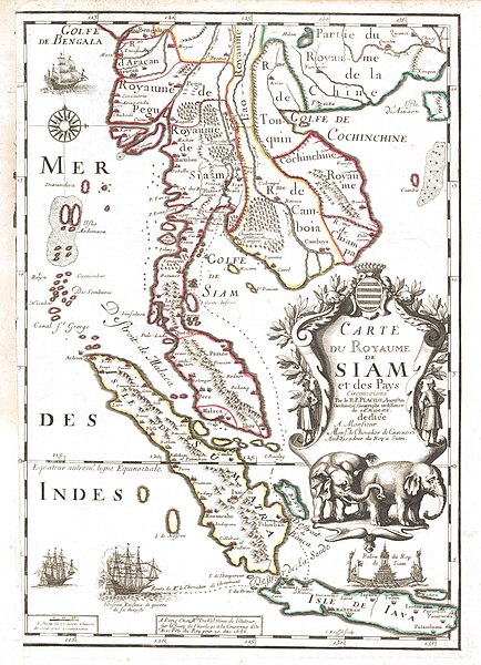
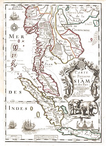
English: Map of the Kingdom of Siam and its neighbouring countries Français : Carte du royaume de Siam et des pays circonvoisins |
| កាលបរិច្ឆេទ | |
| ប្រភព | [1] |
| អ្នកនិពន្ធ | R. Placide Augustin Dechaussé (Paris 1649 - ibidem 1734), augustin déchaussé, géographe ordinaire de Sa Majesté |
| ទំរង់ផ្សេងទៀត | BNF |
ការដាក់អាជ្ញាប័ណ្ណ
|
This is a faithful photographic reproduction of a two-dimensional, public domain work of art. The work of art itself is in the public domain for the following reason:
The official position taken by the Wikimedia Foundation is that "faithful reproductions of two-dimensional public domain works of art are public domain".
This photographic reproduction is therefore also considered to be in the public domain in the United States. In other jurisdictions, re-use of this content may be restricted; see Reuse of PD-Art photographs for details. | ||||
ប្រវត្តិឯកសារ
ចុចលើម៉ោងនិងកាលបរិច្ឆេទដើម្បីមើលឯកសារដែលបានផ្ទុកឡើងនៅពេលនោះ។
| ម៉ោងនិងកាលបរិច្ឆេទ | កូនរូបភាព | វិមាត្រ | អ្នកប្រើប្រាស់ | យោបល់ | |
|---|---|---|---|---|---|
| បច្ចុប្បន្ន | ម៉ោង១២:១៨ ថ្ងៃព្រហស្បតិ៍ ទី០៨ ខែកុម្ភៈ ឆ្នាំ២០១៨ | | ២៨៣១ × ៣៩១២ (២.៣៤មេកាបៃ) | Gryffindor | {{Information |Description= |Source= |Date= |Author= |Permission= |other_versions= }} |
| ម៉ោង១១:៣៥ ថ្ងៃព្រហស្បតិ៍ ទី២៥ ខែធ្នូ ឆ្នាំ២០១៤ |  | ១៩៦០ × ២៨២២ (២.៧៣មេកាបៃ) | Sodacan | contrasts | |
| ម៉ោង២០:៤៥ ថ្ងៃអង្គារ ទី០៤ ខែវិច្ឆិកា ឆ្នាំ២០០៨ |  | ១៩៦០ × ២៨២២ (២.៤៨មេកាបៃ) | World Imaging | Category:History of Thailand | |
| ម៉ោង១៤:០៧ ថ្ងៃអាទិត្យ ទី១៨ ខែឧសភា ឆ្នាំ២០០៨ |  | ៥៥៨ × ៩០០ (១១៣គីឡូបៃ) | World Imaging | Better image | |
| ម៉ោង១៣:៤១ ថ្ងៃអាទិត្យ ទី១៨ ខែឧសភា ឆ្នាំ២០០៨ |  | ៥៥៨ × ៩០០ (១៥៧គីឡូបៃ) | World Imaging | {{Information |Description=1686 French Map Of Siam |Source=1686 map. Reproduction in [http://www.escati.com/the-making-of-a-nation/]] |Date=1686 |Author=Unknown |Permission= |other_versions= }} |
បម្រើបម្រាស់ឯកសារ
9 ទំព័រ ខាងក្រោមប្រើប្រាស់ឯកសារនេះ ៖
បម្រើបម្រាស់ឯកសារជាសាកល
វីគីដទៃទៀតដូចខាងក្រោមនេះប្រើប្រាស់ឯកសារនេះ៖
- ការប្រើប្រាស់នៅក្នុង af.wikipedia.org
- ការប្រើប្រាស់នៅក្នុង ar.wikipedia.org
- ការប្រើប្រាស់នៅក្នុង ba.wikipedia.org
- ការប្រើប្រាស់នៅក្នុង ckb.wikipedia.org
- ការប្រើប្រាស់នៅក្នុង cs.wikipedia.org
- ការប្រើប្រាស់នៅក្នុង de.wikipedia.org
- ការប្រើប្រាស់នៅក្នុង de.wikivoyage.org
- ការប្រើប្រាស់នៅក្នុង en.wikipedia.org
- History of Thailand
- Ayutthaya Kingdom
- Post-Angkor period
- Srivijaya
- History of Isan
- History of Thailand (1973–2001)
- Early history of Thailand
- Rattanakosin Kingdom (1782–1932)
- History of Thailand (1932–1973)
- Template:History of Thailand
- Template talk:History of Thailand
- Military history of Thailand
- Thonburi Kingdom
- Tambralinga
- Initial states of Thailand
- Singhanavati
- Prehistoric Thailand
- User talk:67.150.126.108
- History of Phitsanulok Province
- Peopling of Thailand
- France–Thailand relations
- User:UBX/Thailand
- User:Thailand~enwiki
- User:Pawyilee/Crawfurd Mission
- User:༆/History of Asia templates
- History of Thailand (2001–present)
- User:ผู้บ่าวไทบ้าน/sandbox
- Anglo-Siamese War
- User:Lalalulilalia/sandbox
- Malay invasions of Sri Lanka
- User:Nickicooo/Siam's annexation of Chiang Mai
- Canasapura
- Draft:Sri Kotrabun
- Wen Dan
- ការប្រើប្រាស់នៅក្នុង fi.wikipedia.org
- ការប្រើប្រាស់នៅក្នុង fr.wikipedia.org
- ការប្រើប្រាស់នៅក្នុង hr.wiktionary.org
- ការប្រើប្រាស់នៅក្នុង id.wikipedia.org
View more global usage of this file.