
ឯកសារ:Africa-regions.png
គ្មានភាពម៉ត់ខ្ពស់ជាងនេះទេ។
Africa-regions.png (៣៦០ × ៣៩២ ភីកសែល ទំហំឯកសារ៖ ៨គីឡូបៃ ប្រភេទ MIME៖ image/png)
ចំណារពន្យល់
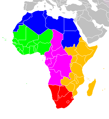
Africa: subregions as delineated by United Nations geographic classification scheme:
ការដាក់អាជ្ញាប័ណ្ណ
I, the copyright holder of this work, hereby publish it under the following licenses:

|
រូបភាពនៃទំព័រនេះជាកម្មសិទ្ធិរបស់GNU Free Documentation License។ Version 1.2 ឬក៏ខ្ពស់ជាងនេះត្រូវបានឧបត្ថមគាំទ្រដោយ មូលនិធិសូហ្វវែរដោយឥតគិតថ្លៃ (Free Software Foundation) ដែលមិនមានផ្នែកណាមួយរបស់ប្រភពដើមរួមទាំងអក្សរនៅលើគំរបមុខនិងខ្នង ត្រូវបានផ្លាស់ប្តូរទេ។ ចំពោះផ្នែកដែលមិនអាចផ្លាស់ប្តូរបាន សូមមើលGNU Free Documentation License។ |
| ឯកសារនេះជាប់អាជ្ញាបណ្ឌCreative Commons Attribution-Share Alike 3.0 Unported។ | ||
| ||
| This licensing tag was added to this file as part of the GFDL licensing update. |
ឯកសារនេះជាប់អាជ្ញាបណ្ឌCreative Commons Attribution-Share Alike 2.5 Generic, 2.0 Generic និង 1.0 Generic។
- អ្នកមានសិទ្ធិ៖
- ចែកចាយ – ថតចំលងនិងចែកចាយស្នាដៃនេះ
- កែច្នៃ – កែច្នៃយកទៅប្រើ
- ក្រោមលក្ខខណ្ឌដូចតទៅនេះ៖
- ភាពជាម្ចាស់កម្មសិទ្ធ – You must give appropriate credit, provide a link to the license, and indicate if changes were made. You may do so in any reasonable manner, but not in any way that suggests the licensor endorses you or your use.
- share alike – If you remix, transform, or build upon the material, you must distribute your contributions under the same or compatible license as the original.
You may select the license of your choice.

|
File:Africa map regions.svg is a vector version of this file. It should be used in place of this PNG file when not inferior.
File:Africa-regions.png → File:Africa map regions.svg
For more information, see Help:SVG. |
 |
ប្រវត្តិឯកសារ
ចុចលើម៉ោងនិងកាលបរិច្ឆេទដើម្បីមើលឯកសារដែលបានផ្ទុកឡើងនៅពេលនោះ។
| ម៉ោងនិងកាលបរិច្ឆេទ | កូនរូបភាព | វិមាត្រ | អ្នកប្រើប្រាស់ | យោបល់ | |
|---|---|---|---|---|---|
| បច្ចុប្បន្ន | ម៉ោង០២:០២ ថ្ងៃសុក្រ ទី០១ ខែមិថុនា ឆ្នាំ២០១៨ | | ៣៦០ × ៣៩២ (៨គីឡូបៃ) | Vesperius | Reverted to version as of 18:36, 28 May 2018 (UTC) (Most definitions of the regions include the Horn of Africa as part of East Africa, so I'm reverting this back) |
| ម៉ោង១៨:៣៧ ថ្ងៃច័ន្ទ ទី២៨ ខែឧសភា ឆ្នាំ២០១៨ |  | ៣៦០ × ៣៩២ (១០គីឡូបៃ) | Vesperius | Reverted to version as of 18:25, 28 May 2018 (UTC) (Messed up, the purple indicating the Horn of Africa didn't show up for me) | |
| ម៉ោង១៨:៣៦ ថ្ងៃច័ន្ទ ទី២៨ ខែឧសភា ឆ្នាំ២០១៨ |  | ៣៦០ × ៣៩២ (៨គីឡូបៃ) | Vesperius | Reverted to version as of 01:04, 16 May 2018 (UTC) | |
| ម៉ោង១៨:២៥ ថ្ងៃច័ន្ទ ទី២៨ ខែឧសភា ឆ្នាំ២០១៨ |  | ៣៦០ × ៣៩២ (១០គីឡូបៃ) | Vesperius | Reverted to version as of 18:57, 17 March 2018 (UTC) | |
| ម៉ោង០១:០៤ ថ្ងៃពុធ ទី១៦ ខែឧសភា ឆ្នាំ២០១៨ |  | ៣៦០ × ៣៩២ (៨គីឡូបៃ) | Dwo | Reverted to version as of 08:22, 30 August 2015 (UTC) | |
| ម៉ោង១៨:៥៧ ថ្ងៃសៅរ៍ ទី១៧ ខែមីនា ឆ្នាំ២០១៨ |  | ៣៦០ × ៣៩២ (១០គីឡូបៃ) | Maphobbyist | Montenegro border | |
| ម៉ោង០៨:២២ ថ្ងៃអាទិត្យ ទី៣០ ខែសីហា ឆ្នាំ២០១៥ |  | ៣៦០ × ៣៩២ (៨គីឡូបៃ) | Wiki-Zyron | Reverted to version as of 00:23, 20 December 2012 - Reverted to the last version before someone inexplicably moved Zimbabwe to Southern Africa. Eastern Africa is the correct region - [http://unstats.un.org/unsd/methods/m49/m49regin.htm#africa] | |
| ម៉ោង០៥:០៤ ថ្ងៃអង្គារ ទី២១ ខែមេសា ឆ្នាំ២០១៥ |  | ៣៦០ × ៣៩២ (១៦គីឡូបៃ) | TAKASUGI Shinji | Corrected the color of Zimbabwe | |
| ម៉ោង១៥:១៦ ថ្ងៃព្រហស្បតិ៍ ទី១៨ ខែធ្នូ ឆ្នាំ២០១៤ |  | ៣៦០ × ៣៩២ (១៧គីឡូបៃ) | Hybscher | wrong colors | |
| ម៉ោង២២:៣៩ ថ្ងៃសៅរ៍ ទី២២ ខែវិច្ឆិកា ឆ្នាំ២០១៤ |  | ២០០០ × ២០៥០ (៣៤២គីឡូបៃ) | Andrew J.Kurbiko | pp |
បម្រើបម្រាស់ឯកសារ
ទំព័រ ខាងក្រោមប្រើប្រាស់ឯកសារនេះ ៖
បម្រើបម្រាស់ឯកសារជាសាកល
វីគីដទៃទៀតដូចខាងក្រោមនេះប្រើប្រាស់ឯកសារនេះ៖
- ការប្រើប្រាស់នៅក្នុង af.wikipedia.org
- ការប្រើប្រាស់នៅក្នុង anp.wikipedia.org
- ការប្រើប្រាស់នៅក្នុង ar.wikipedia.org
- ការប្រើប្រាស់នៅក្នុង arz.wikipedia.org
- ការប្រើប្រាស់នៅក្នុង avk.wikipedia.org
- ការប្រើប្រាស់នៅក្នុង azb.wikipedia.org
- ការប្រើប្រាស់នៅក្នុង ba.wikipedia.org
- ការប្រើប្រាស់នៅក្នុង bg.wikipedia.org
- ការប្រើប្រាស់នៅក្នុង blk.wikipedia.org
- ការប្រើប្រាស់នៅក្នុង bn.wikipedia.org
- ការប្រើប្រាស់នៅក្នុង br.wikipedia.org
- ការប្រើប្រាស់នៅក្នុង bxr.wikipedia.org
- ការប្រើប្រាស់នៅក្នុង ca.wikipedia.org
- ការប្រើប្រាស់នៅក្នុង cy.wikipedia.org
- ការប្រើប្រាស់នៅក្នុង de.wikipedia.org
- ការប្រើប្រាស់នៅក្នុង el.wikipedia.org
- ការប្រើប្រាស់នៅក្នុង en.wikipedia.org
- Southern Africa
- Walvis Bay-Ndola-Lubumbashi Development Road
- N1 road (Gabon)
- User:R4000/Africa(Alt)
- Cairo Road
- User:ArminHammer
- User:Donbert/motherafrica
- User:Donbert/userboxes
- United Nations geoscheme
- United Nations geoscheme for Africa
- Rua Libertadores de África
- Lists of cities in Africa
- Portuguese Africans
- Sam Nujoma Street
- Cairo–Dakar Highway
- N'Djamena–Djibouti Highway
- Portal:Africa/Countries
View more global usage of this file.