
ឯកសារ:AntarcticBedrock2.jpg

ទំហំរបស់ការមើលមុននេះ: ៦០០ × ៦០០ ភីកសែ។ ភាពម៉ត់ផ្សេងទៀត៖ ២៤០ × ២៤០ ភីកសែ | ៤៨០ × ៤៨០ ភីកសែ | ៧៦៨ × ៧៦៨ ភីកសែ | ១០២៤ × ១០២៤ ភីកសែ | ១៣៣៣ × ១៣៣៣ ភីកសែ។
រូបភាពដើម (១៣៣៣ × ១៣៣៣ ភីកសែល ទំហំឯកសារ៖ ៤២៥គីឡូបៃ ប្រភេទ MIME៖ image/jpeg)
ចំណារពន្យល់
| ការពិពណ៌នា |
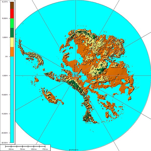
English: The above map shows the subglacial topography of Antarctica. As indicated by the scale on left-hand side, blue represents portions of Antarctica lying below sea level. The other colors indicate Antarctic bedrock lying above sea level. Each color represents an interval of 2,500 feet in elevation. Map is not corrected for sea level rise or isostatic rebound, which would occur if the Antarctic ice sheet completely melted to expose the bedrock surface. |
| កាលបរិច្ឆេទ | |
| ប្រភព | ការងារផ្ទាល់របស់អ្នកផ្ទុកឡើង |
| អ្នកនិពន្ធ | Cristellaria |
| ទំរង់ផ្សេងទៀត | Image:AntarcticBedrock.jpg |
ការដាក់អាជ្ញាប័ណ្ណ
I, the copyright holder of this work, hereby publish it under the following license:
ឯកសារនេះជាប់អាជ្ញាបណ្ឌCreative Commons Attribution 3.0 Unported។
- អ្នកមានសិទ្ធិ៖
- ចែកចាយ – ថតចំលងនិងចែកចាយស្នាដៃនេះ
- កែច្នៃ – កែច្នៃយកទៅប្រើ
- ក្រោមលក្ខខណ្ឌដូចតទៅនេះ៖
- ភាពជាម្ចាស់កម្មសិទ្ធ – You must give appropriate credit, provide a link to the license, and indicate if changes were made. You may do so in any reasonable manner, but not in any way that suggests the licensor endorses you or your use.
ប្រវត្តិឯកសារ
ចុចលើម៉ោងនិងកាលបរិច្ឆេទដើម្បីមើលឯកសារដែលបានផ្ទុកឡើងនៅពេលនោះ។
| ម៉ោងនិងកាលបរិច្ឆេទ | កូនរូបភាព | វិមាត្រ | អ្នកប្រើប្រាស់ | យោបល់ | |
|---|---|---|---|---|---|
| បច្ចុប្បន្ន | ម៉ោង០៤:២៨ ថ្ងៃព្រហស្បតិ៍ ទី២៨ ខែសីហា ឆ្នាំ២០០៨ | | ១៣៣៣ × ១៣៣៣ (៤២៥គីឡូបៃ) | Cristellaria | {{Information |Description={{en|1=Description=The above map shows the subglacial topography of Antarctica. As indicated by the scale on left-hand side, blue represents portion of Antarctica lying below sea level. The other colors indicate Antarctic bedroc |
បម្រើបម្រាស់ឯកសារ
គ្មានទំព័រណាមួយដែលប្រើប្រាស់ឯកសារនេះទេ។
បម្រើបម្រាស់ឯកសារជាសាកល
វីគីដទៃទៀតដូចខាងក្រោមនេះប្រើប្រាស់ឯកសារនេះ៖
- ការប្រើប្រាស់នៅក្នុង ar.wikipedia.org
- ការប្រើប្រាស់នៅក្នុង ba.wikipedia.org
- ការប្រើប្រាស់នៅក្នុង bxr.wikipedia.org
- ការប្រើប្រាស់នៅក្នុង ca.wikipedia.org
- ការប្រើប្រាស់នៅក្នុង de.wikipedia.org
- ការប្រើប្រាស់នៅក្នុង es.wikipedia.org
- ការប្រើប្រាស់នៅក្នុង hy.wikipedia.org
- ការប្រើប្រាស់នៅក្នុង it.wikipedia.org
- ការប្រើប្រាស់នៅក្នុង ka.wikipedia.org
- ការប្រើប្រាស់នៅក្នុង kn.wikipedia.org
- ការប្រើប្រាស់នៅក្នុង no.wikipedia.org
- ការប្រើប្រាស់នៅក្នុង ru.wikipedia.org
- ការប្រើប្រាស់នៅក្នុង tr.wikipedia.org
- ការប្រើប្រាស់នៅក្នុង uk.wikipedia.org
- ការប្រើប្រាស់នៅក្នុង zh.wikipedia.org