
ឯកសារ:Antarctica, Argentina territorial claim.svg

Size of this PNG preview of this SVG file: ៦០០ × ៦០០ ភីកសែ. ភាពម៉ត់ផ្សេងទៀត៖ ២៤០ × ២៤០ ភីកសែ | ៤៨០ × ៤៨០ ភីកសែ | ៧៦៨ × ៧៦៨ ភីកសែ | ១០២៤ × ១០២៤ ភីកសែ | ២០៤៨ × ២០៤៨ ភីកសែ | ៨០៦ × ៨០៦ ភីកសែ។
រូបភាពដើម (ឯកសារប្រភេទSVG ៨០៦ × ៨០៦ ភីកសែល ទំហំឯកសារ៖ ៦៥គីឡូបៃ)
| ការពិពណ៌នា |
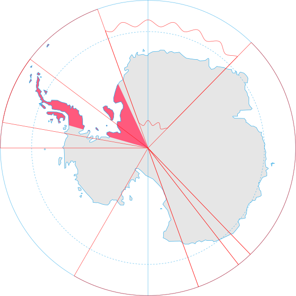
English: Map showing the territorial claim to Antarctica by the country in the filename. Also on the map are is the 60° S Parallel, Antarctic Circle, 0/180 latitude line and (in red) the borders of the claims by other states. |
| កាលបរិច្ឆេទ | |
| ប្រភព | Generated from Antarctica by Lokal_Profil. |
| អ្នកនិពន្ធ | Lokal_Profil |
| ការអនុញ្ញាត (ប្រើឯកសារនេះឡើងវិញ) |
ឯកសារនេះជាប់អាជ្ញាបណ្ឌCreative Commons Attribution-Share Alike 2.5 Generic។ ភាពជាម្ចាស់កម្មសិទ្ធ: Lokal_Profil
|
ប្រវត្តិឯកសារ
ចុចលើម៉ោងនិងកាលបរិច្ឆេទដើម្បីមើលឯកសារដែលបានផ្ទុកឡើងនៅពេលនោះ។
| ម៉ោងនិងកាលបរិច្ឆេទ | កូនរូបភាព | វិមាត្រ | អ្នកប្រើប្រាស់ | យោបល់ | |
|---|---|---|---|---|---|
| បច្ចុប្បន្ន | ម៉ោង២០:៥៥ ថ្ងៃច័ន្ទ ទី៣០ ខែមិថុនា ឆ្នាំ២០០៨ | | ៨០៦ × ៨០៦ (៦៥គីឡូបៃ) | Lokal Profil | {{Information |Description={{en|Map showing the territorial claim to Antarctica by the country in the filename. Also on the map are is the 60° S Parallel, Antarctic Circle, 0/180 latitude line and (in red) the borders of the claims by other states.}} |So |
បម្រើបម្រាស់ឯកសារ
គ្មានទំព័រណាមួយដែលប្រើប្រាស់ឯកសារនេះទេ។
បម្រើបម្រាស់ឯកសារជាសាកល
វីគីដទៃទៀតដូចខាងក្រោមនេះប្រើប្រាស់ឯកសារនេះ៖
- ការប្រើប្រាស់នៅក្នុង af.wikipedia.org
- ការប្រើប្រាស់នៅក្នុង ar.wikipedia.org
- ការប្រើប្រាស់នៅក្នុង ast.wikipedia.org
- ការប្រើប្រាស់នៅក្នុង az.wikipedia.org
- ការប្រើប្រាស់នៅក្នុង ca.wikipedia.org
- ការប្រើប្រាស់នៅក្នុង chr.wikipedia.org
- ការប្រើប្រាស់នៅក្នុង ckb.wikipedia.org
- ការប្រើប្រាស់នៅក្នុង cs.wikipedia.org
- ការប្រើប្រាស់នៅក្នុង da.wikipedia.org
- ការប្រើប្រាស់នៅក្នុង de.wikipedia.org
- ការប្រើប្រាស់នៅក្នុង diq.wikipedia.org
- ការប្រើប្រាស់នៅក្នុង el.wikipedia.org
- ការប្រើប្រាស់នៅក្នុង en.wikipedia.org
- ការប្រើប្រាស់នៅក្នុង eo.wikipedia.org
- ការប្រើប្រាស់នៅក្នុង et.wikipedia.org
- ការប្រើប្រាស់នៅក្នុង eu.wikipedia.org
- ការប្រើប្រាស់នៅក្នុង fa.wikipedia.org
- ការប្រើប្រាស់នៅក្នុង fi.wikipedia.org
- ការប្រើប្រាស់នៅក្នុង frr.wikipedia.org
- ការប្រើប្រាស់នៅក្នុង fr.wikipedia.org
- ការប្រើប្រាស់នៅក្នុង gl.wikipedia.org
- ការប្រើប្រាស់នៅក្នុង gv.wikipedia.org
- ការប្រើប្រាស់នៅក្នុង hu.wikipedia.org
- ការប្រើប្រាស់នៅក្នុង hy.wikipedia.org
- ការប្រើប្រាស់នៅក្នុង id.wikipedia.org
- ការប្រើប្រាស់នៅក្នុង ilo.wikipedia.org
- ការប្រើប្រាស់នៅក្នុង it.wikipedia.org
- ការប្រើប្រាស់នៅក្នុង ja.wikipedia.org
View more global usage of this file.