
ឯកសារ:AralSeaAug1964-keyhole.jpg
ទំហំរបស់ការមើលមុននេះ: ៦០០ × ៥៩៩ ភីកសែ។ ភាពម៉ត់ផ្សេងទៀត៖ ២៤០ × ២៤០ ភីកសែ | ៤៨១ × ៤៨០ ភីកសែ | ៧៦៩ × ៧៦៨ ភីកសែ | ១០២៥ × ១០២៤ ភីកសែ | ១៥៥៦ × ១៥៥៤ ភីកសែ។
រូបភាពដើម (១៥៥៦ × ១៥៥៤ ភីកសែល ទំហំឯកសារ៖ ១.១១មេកាបៃ ប្រភេទ MIME៖ image/jpeg)
ចំណារពន្យល់
| ការពិពណ៌នា |
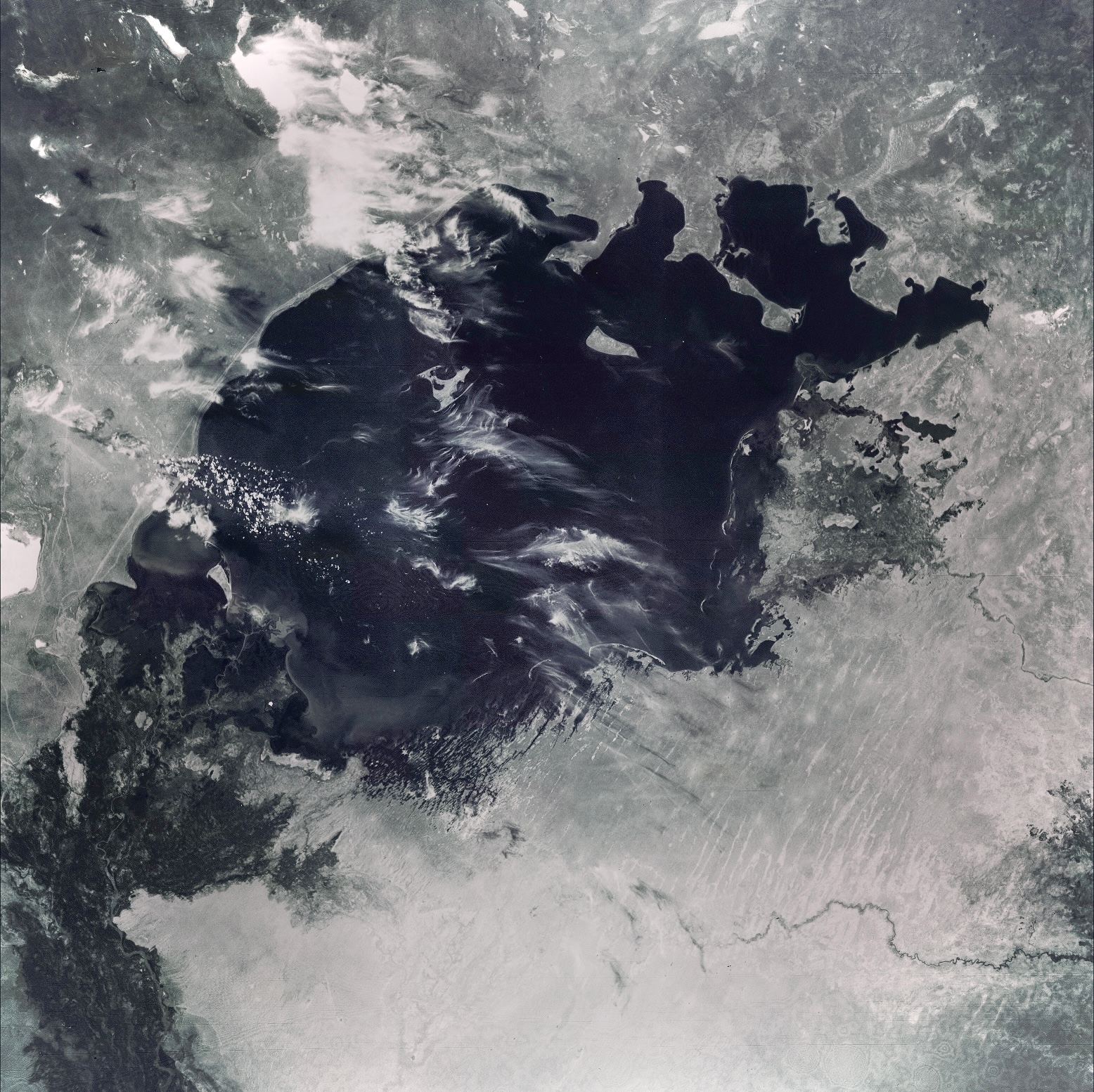
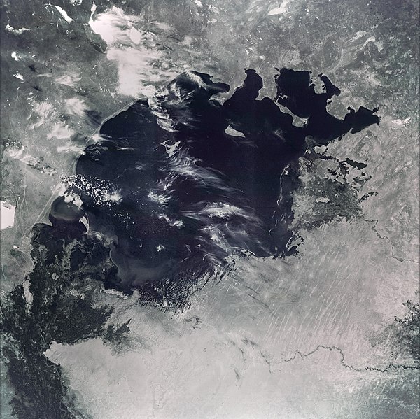
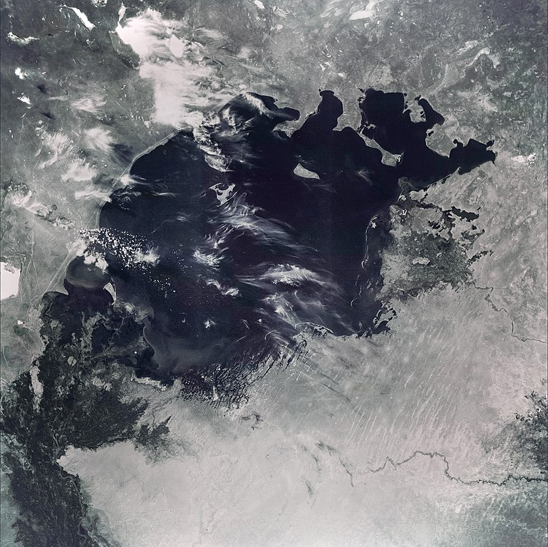
English: This image of the Aral Sea was acquired in August of 1964 by a United States Argon intelligence mapping/geodesy satellite.
KH-5 Mission 9064-A (incorrectly mislabeled 9066-A in the USGS archive) carried the A-22 mapping camera. A TAT-Agena carried this camera into an orbit of 114.96 degrees of inclination with a period of 84 minutes, a perigee of 219 degrees and an apogee of 232 degrees. International Launch Designation: 1964-043A Launch Date: August 21, 1964 Mission Duration: approximately 6 days |
| កាលបរិច្ឆេទ | |
| ប្រភព | The Aral Sea, Before the Streams Ran Dry - NASA Earth Observatory |
| អ្នកនិពន្ធ | Image from the U.S. Air Force KH-5 9066A reconnaissance satellite, the last of the Argon series. |
ការដាក់អាជ្ញាប័ណ្ណ
| This file is in the public domain in the United States because it was solely created by NASA. NASA copyright policy states that "NASA material is not protected by copyright unless noted". (See Template:PD-USGov, NASA copyright policy page or JPL Image Use Policy.) | ||
 |
Warnings:
|
Original upload log
The original description page was here. All following user names refer to en.wikipedia.
- 2006-07-05 05:48 Hartze11 450×450×8 (35583 bytes) This image of the Aral Sea was acquired in August of 1964 by a United States intelligence mapping satellite.
| Annotations | This image is annotated: View the annotations at Commons |

ប្រវត្តិឯកសារ
ចុចលើម៉ោងនិងកាលបរិច្ឆេទដើម្បីមើលឯកសារដែលបានផ្ទុកឡើងនៅពេលនោះ។
| ម៉ោងនិងកាលបរិច្ឆេទ | កូនរូបភាព | វិមាត្រ | អ្នកប្រើប្រាស់ | យោបល់ | |
|---|---|---|---|---|---|
| បច្ចុប្បន្ន | ម៉ោង២០:១១ ថ្ងៃច័ន្ទ ទី៣០ ខែឧសភា ឆ្នាំ២០២២ | | ១៥៥៦ × ១៥៥៤ (១.១១មេកាបៃ) | Italyoz484 | Fixed haze. |
| ម៉ោង១៤:៥៦ ថ្ងៃព្រហស្បតិ៍ ទី០៩ ខែកញ្ញា ឆ្នាំ២០២១ |  | ១៥៥៦ × ១៥៥៤ (១.០៨មេកាបៃ) | LightandDark2000 | Reverted to version as of 06:33, 5 August 2021 (UTC) That looks worse. | |
| ម៉ោង១៨:២១ ថ្ងៃអាទិត្យ ទី០៥ ខែកញ្ញា ឆ្នាំ២០២១ |  | ៨០០ × ៨០០ (១០៥គីឡូបៃ) | PineappIed | more accurate depiction | |
| ម៉ោង១៨:១៦ ថ្ងៃអាទិត្យ ទី០៥ ខែកញ្ញា ឆ្នាំ២០២១ |  | ៣៩៣០ × ៣៩៣០ (២.៩មេកាបៃ) | PineappIed | ||
| ម៉ោង០៦:៣៣ ថ្ងៃព្រហស្បតិ៍ ទី០៥ ខែសីហា ឆ្នាំ២០២១ |  | ១៥៥៦ × ១៥៥៤ (១.០៨មេកាបៃ) | Italyoz484 | coloration | |
| ម៉ោង១០:៥៣ ថ្ងៃពុធ ទី០១ ខែតុលា ឆ្នាំ២០១៤ |  | ៣៩៣០ × ៣៩៣០ (២.៩មេកាបៃ) | Szczureq | Full resolution found at NASA Earth Observatory (http://earthobservatory.nasa.gov/IOTD/view.php?id=77193) | |
| ម៉ោង២២:៥២ ថ្ងៃព្រហស្បតិ៍ ទី១០ ខែមករា ឆ្នាំ២០០៨ |  | ៤៥០ × ៤៥០ (៣៥គីឡូបៃ) | File Upload Bot (Magnus Manske) | {{BotMoveToCommons|en.wikipedia}} {{Information |Description={{en|This image of the Aral Sea was acquired in August of 1964 by a United States Argon intelligence mapping/geodesy satellite. KH-5 Mission 9064-A (incorrectly mislabeled 9066-A in the USGS |
បម្រើបម្រាស់ឯកសារ
ទំព័រ ខាងក្រោមប្រើប្រាស់ឯកសារនេះ ៖
បម្រើបម្រាស់ឯកសារជាសាកល
វីគីដទៃទៀតដូចខាងក្រោមនេះប្រើប្រាស់ឯកសារនេះ៖
- ការប្រើប្រាស់នៅក្នុង ba.wikipedia.org
- ការប្រើប្រាស់នៅក្នុង de.wikipedia.org
- ការប្រើប្រាស់នៅក្នុង it.wikipedia.org
- ការប្រើប្រាស់នៅក្នុង nn.wikipedia.org
- ការប្រើប្រាស់នៅក្នុង pl.wikipedia.org
- ការប្រើប្រាស់នៅក្នុង ru.wikipedia.org
- ការប្រើប្រាស់នៅក្នុង ta.wikipedia.org