
ឯកសារ:Atafutrim.jpg

ទំហំរបស់ការមើលមុននេះ: ៨០០ × ៥៦៦ ភីកសែ។ ភាពម៉ត់ផ្សេងទៀត៖ ៣២០ × ២២៦ ភីកសែ | ៦៤០ × ៤៥២ ភីកសែ | ១០២៤ × ៧២៤ ភីកសែ | ១២៨០ × ៩០៥ ភីកសែ | ២០៨៨ × ១៤៧៦ ភីកសែ។
រូបភាពដើម (២០៨៨ × ១៤៧៦ ភីកសែល ទំហំឯកសារ៖ ១.១៦មេកាបៃ ប្រភេទ MIME៖ image/jpeg)
| ការពិពណ៌នា |
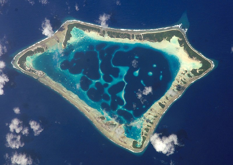
Cropped version of Atafu.jpg
|
| កាលបរិច្ឆេទ | (UTC) |
| ប្រភព | |
| អ្នកនិពន្ធ |
|
| Object location | | រូបភាពនេះនិងរូបភាពផ្សេងទៀតនៅឯទីតាំងរបស់វាលើ: OpenStreetMap |
|---|
| This file is in the public domain in the United States because it was solely created by NASA. NASA copyright policy states that "NASA material is not protected by copyright unless noted". (See Template:PD-USGov, NASA copyright policy page or JPL Image Use Policy.) | ||
 |
Warnings:
|
Original upload log
This image is a derivative work of the following images:
- File:Atafu.jpg licensed with PD-USGov-NASA
Uploaded with derivativeFX

|
This image has been assessed under the valued image criteria and is considered the most valued image on Commons within the scope: Atafu atoll, Tokelau - satellite view. You can see its nomination here. |
ប្រវត្តិឯកសារ
ចុចលើម៉ោងនិងកាលបរិច្ឆេទដើម្បីមើលឯកសារដែលបានផ្ទុកឡើងនៅពេលនោះ។
| ម៉ោងនិងកាលបរិច្ឆេទ | កូនរូបភាព | វិមាត្រ | អ្នកប្រើប្រាស់ | យោបល់ | |
|---|---|---|---|---|---|
| បច្ចុប្បន្ន | ម៉ោង០០:១២ ថ្ងៃច័ន្ទ ទី០២ ខែមីនា ឆ្នាំ២០០៩ | | ២០៨៨ × ១៤៧៦ (១.១៦មេកាបៃ) | Talkstosocks | {{Information |Description=Cropped version of Atafu.jpg *{{en|Satellite picture of the Atafu atoll in Tokelau.}} *{{es|Imágen de satélite de Atafu.}} *{{de|Satellitenbild des Atafu Atolls in Tokelau.}} |Source=*File:Atafu.jpg |Dat |
បម្រើបម្រាស់ឯកសារ
ទំព័រ ខាងក្រោមប្រើប្រាស់ឯកសារនេះ ៖
បម្រើបម្រាស់ឯកសារជាសាកល
វីគីដទៃទៀតដូចខាងក្រោមនេះប្រើប្រាស់ឯកសារនេះ៖
- ការប្រើប្រាស់នៅក្នុង ace.wikipedia.org
- ការប្រើប្រាស់នៅក្នុង als.wikipedia.org
- ការប្រើប្រាស់នៅក្នុង ar.wikipedia.org
- ការប្រើប្រាស់នៅក្នុង bh.wikipedia.org
- ការប្រើប្រាស់នៅក្នុង bn.wikipedia.org
- ការប្រើប្រាស់នៅក្នុង bs.wikipedia.org
- ការប្រើប្រាស់នៅក្នុង cs.wikipedia.org
- ការប្រើប្រាស់នៅក្នុង de.wikipedia.org
- ការប្រើប្រាស់នៅក្នុង el.wiktionary.org
- ការប្រើប្រាស់នៅក្នុង en.wikipedia.org
- ការប្រើប្រាស់នៅក្នុង en.wiktionary.org
- ការប្រើប្រាស់នៅក្នុង es.wikipedia.org
- ការប្រើប្រាស់នៅក្នុង es.wikibooks.org
- ការប្រើប្រាស់នៅក្នុង eu.wikipedia.org
- ការប្រើប្រាស់នៅក្នុង fa.wikipedia.org
- ការប្រើប្រាស់នៅក្នុង fr.wikipedia.org
- ការប្រើប្រាស់នៅក្នុង ga.wikipedia.org
- ការប្រើប្រាស់នៅក្នុង he.wikipedia.org
- ការប្រើប្រាស់នៅក្នុង hi.wikipedia.org
- ការប្រើប្រាស់នៅក្នុង ia.wikipedia.org
- ការប្រើប្រាស់នៅក្នុង id.wikipedia.org
- ការប្រើប្រាស់នៅក្នុង id.wiktionary.org
- ការប្រើប្រាស់នៅក្នុង is.wikipedia.org
- ការប្រើប្រាស់នៅក្នុង kbd.wikipedia.org
- ការប្រើប្រាស់នៅក្នុង ko.wikipedia.org
- ការប្រើប្រាស់នៅក្នុង ku.wiktionary.org
- ការប្រើប្រាស់នៅក្នុង la.wikipedia.org
- ការប្រើប្រាស់នៅក្នុង lv.wikipedia.org
- ការប្រើប្រាស់នៅក្នុង mdf.wikipedia.org
- ការប្រើប្រាស់នៅក្នុង mk.wikipedia.org
- ការប្រើប្រាស់នៅក្នុង ml.wikipedia.org
- ការប្រើប្រាស់នៅក្នុង ms.wikipedia.org
View more global usage of this file.