
ឯកសារ:EU-Poland.svg

Size of this PNG preview of this SVG file: ៧១៣ × ៦០០ ភីកសែ. ភាពម៉ត់ផ្សេងទៀត៖ ២៨៥ × ២៤០ ភីកសែ | ៥៧១ × ៤៨០ ភីកសែ | ៩១៣ × ៧៦៨ ភីកសែ | ១២១៨ × ១០២៤ ភីកសែ | ២៤៣៥ × ២០៤៨ ភីកសែ | ២០៤៥ × ១៧២០ ភីកសែ។
រូបភាពដើម (ឯកសារប្រភេទSVG ២០៤៥ × ១៧២០ ភីកសែល ទំហំឯកសារ៖ ៧.៣៣មេកាបៃ)
польша
ចំណារពន្យល់
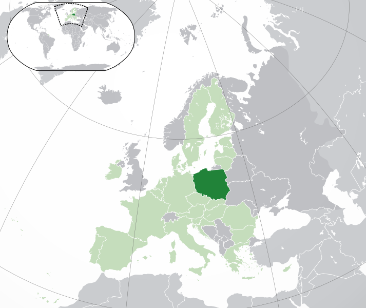
Polski:
(Green) Polska.
(Light-green) Unia Europejska (UE).
(Gray) Europa.
(Light-gray) Inne terytoria.
| ការពិពណ៌នា |
English: (Dark-Green) Poland. (Light-Green) The rest of the European Union (EU). (Dark-gray) The rest of Europe. (Light-gray) The surrounding region.
See also: |
| SVG genesis | ធំរូបភាពក្រាភិកវ៉ិចទ័រនេះត្រូវបានបង្កើតឡើងដោយប្រើ Inkscape. |
| កាលបរិច្ឆេទ | |
| ប្រភព | Own work based on: Location European nation states.svg |
| អ្នកនិពន្ធ | NuclearVacuum |
| ទំរង់ផ្សេងទៀត |
|
| SVG genesis | ធំរូបភាពក្រាភិកវ៉ិចទ័រនេះត្រូវបានបង្កើតឡើងដោយប្រើ Inkscape. |


ការដាក់អាជ្ញាប័ណ្ណ
I, the copyright holder of this work, hereby publish it under the following licenses:
ឯកសារនេះជាប់អាជ្ញាបណ្ឌCreative Commons Attribution-Share Alike 3.0 Unported។
- អ្នកមានសិទ្ធិ៖
- ចែកចាយ – ថតចំលងនិងចែកចាយស្នាដៃនេះ
- កែច្នៃ – កែច្នៃយកទៅប្រើ
- ក្រោមលក្ខខណ្ឌដូចតទៅនេះ៖
- ភាពជាម្ចាស់កម្មសិទ្ធ – You must give appropriate credit, provide a link to the license, and indicate if changes were made. You may do so in any reasonable manner, but not in any way that suggests the licensor endorses you or your use.
- share alike – If you remix, transform, or build upon the material, you must distribute your contributions under the same or compatible license as the original.

|
រូបភាពនៃទំព័រនេះជាកម្មសិទ្ធិរបស់GNU Free Documentation License។ Version 1.2 ឬក៏ខ្ពស់ជាងនេះត្រូវបានឧបត្ថមគាំទ្រដោយ មូលនិធិសូហ្វវែរដោយឥតគិតថ្លៃ (Free Software Foundation) ដែលមិនមានផ្នែកណាមួយរបស់ប្រភពដើមរួមទាំងអក្សរនៅលើគំរបមុខនិងខ្នង ត្រូវបានផ្លាស់ប្តូរទេ។ ចំពោះផ្នែកដែលមិនអាចផ្លាស់ប្តូរបាន សូមមើលGNU Free Documentation License។ |
You may select the license of your choice.
ប្រវត្តិឯកសារ
ចុចលើម៉ោងនិងកាលបរិច្ឆេទដើម្បីមើលឯកសារដែលបានផ្ទុកឡើងនៅពេលនោះ។
| ម៉ោងនិងកាលបរិច្ឆេទ | កូនរូបភាព | វិមាត្រ | អ្នកប្រើប្រាស់ | យោបល់ | |
|---|---|---|---|---|---|
| បច្ចុប្បន្ន | ម៉ោង០៥:១៩ ថ្ងៃសៅរ៍ ទី០១ ខែកុម្ភៈ ឆ្នាំ២០២០ | | ២០៤៥ × ១៧២០ (៧.៣៣មេកាបៃ) | Rob984 | UK and Gibraltar have left the EU. New base which includes all of Portugal's islands within frame, as well as Arctic Russian islands part of Europe. Also fixed Flevoland in the Netherlands. |
| ម៉ោង២០:៣៤ ថ្ងៃអង្គារ ទី២៥ ខែតុលា ឆ្នាំ២០១៦ |  | ២០៤៥ × ១៧២០ (៧.៣២មេកាបៃ) | Giorgi Balakhadze | fix | |
| ម៉ោង០៩:២៥ ថ្ងៃព្រហស្បតិ៍ ទី២៤ ខែធ្នូ ឆ្នាំ២០១៥ |  | ២០៤៥ × ១៧២០ (៧.៣៣មេកាបៃ) | Nordwestern | Per original framework and Commons' rules. Agree with A2D2. | |
| ម៉ោង១៥:៥៨ ថ្ងៃពុធ ទី១៨ ខែមីនា ឆ្នាំ២០១៥ |  | ២០៤៥ × ១៧២០ (៧.៣៨មេកាបៃ) | Mapclean | Reverted to Leftcry's version, please go to your talk page | |
| ម៉ោង១៤:១០ ថ្ងៃសៅរ៍ ទី២១ ខែកុម្ភៈ ឆ្នាំ២០១៥ |  | ២០៤៥ × ១៧២០ (២.៦១មេកាបៃ) | VS6507 | Spain. Greece. Slovakia. Cyprus. Romania VETO | |
| ម៉ោង១៩:៣៤ ថ្ងៃអាទិត្យ ទី១៦ ខែវិច្ឆិកា ឆ្នាំ២០១៤ |  | ២០៤៥ × ១៧២០ (៧.៣៨មេកាបៃ) | Leftcry | Reverted to version as of 15:48, 6 August 2014 Please go to your talk page | |
| ម៉ោង១៦:៣៦ ថ្ងៃអាទិត្យ ទី១៦ ខែវិច្ឆិកា ឆ្នាំ២០១៤ |  | ២០៤៥ × ១៧២០ (២.៦១មេកាបៃ) | A2D2 | The map must show the original de-jure status with no breakaway regions, as it was originally created. An alternative map showing the de-facto status with breakaway regions needs to be created instead. | |
| ម៉ោង១៥:៤៨ ថ្ងៃពុធ ទី០៦ ខែសីហា ឆ្នាំ២០១៤ |  | ២០៤៥ × ១៧២០ (៧.៣៨មេកាបៃ) | Rob984 | Improved version: More accurate coastline, borders, etc. Added Gradient and Longitude and latitude lines. Sudan border. | |
| ម៉ោង០៩:៣១ ថ្ងៃច័ន្ទ ទី០១ ខែកក្កដា ឆ្នាំ២០១៣ |  | ២០៤៥ × ១៧២០ (២.៦១មេកាបៃ) | U5K0 | croatia | |
| ម៉ោង១៤:៤១ ថ្ងៃសុក្រ ទី២៣ ខែតុលា ឆ្នាំ២០០៩ |  | ២០៤៥ × ១៧២០ (២.៥៩មេកាបៃ) | NuclearVacuum | consensus version |
បម្រើបម្រាស់ឯកសារ
ទំព័រ ខាងក្រោមប្រើប្រាស់ឯកសារនេះ ៖
បម្រើបម្រាស់ឯកសារជាសាកល
វីគីដទៃទៀតដូចខាងក្រោមនេះប្រើប្រាស់ឯកសារនេះ៖
- ការប្រើប្រាស់នៅក្នុង ace.wikipedia.org
- ការប្រើប្រាស់នៅក្នុង ady.wikipedia.org
- ការប្រើប្រាស់នៅក្នុង af.wikipedia.org
- ការប្រើប្រាស់នៅក្នុង ami.wikipedia.org
- ការប្រើប្រាស់នៅក្នុង ar.wikipedia.org
- العلاقات البولندية السعودية
- مستخدم:ElWaliElAlaoui/ملعب 8
- معاملة المثليين في بولندا
- مستخدم:جار الله/قائمة صور مقالات العلاقات الثنائية
- العلاقات الأمريكية البولندية
- العلاقات الأنغولية البولندية
- العلاقات البولندية الكورية الجنوبية
- العلاقات الإريترية البولندية
- العلاقات البولندية السويسرية
- العلاقات البولندية الليختنشتانية
- العلاقات البولندية البوليفية
- العلاقات البولندية الموزمبيقية
- العلاقات الألبانية البولندية
- العلاقات البلجيكية البولندية
- العلاقات الإثيوبية البولندية
- العلاقات البولندية البيلاروسية
- العلاقات البولندية الطاجيكستانية
- العلاقات البولندية الروسية
- العلاقات الأرجنتينية البولندية
- العلاقات البولندية الغامبية
- العلاقات البولندية القبرصية
- العلاقات البولندية السيراليونية
- العلاقات البولندية النيبالية
- العلاقات البولندية الليبيرية
- العلاقات التشيكية البولندية
- العلاقات البولندية الميانمارية
- العلاقات البولندية الكندية
- العلاقات البولندية الزيمبابوية
- العلاقات الإسرائيلية البولندية
- العلاقات البالاوية البولندية
- العلاقات البولندية المالية
- العلاقات البولندية النيجيرية
- العلاقات اليمنية البولندية
- العلاقات البولندية الفانواتية
- العلاقات الغابونية البولندية
- العلاقات البنمية البولندية
- العلاقات البولندية الكوبية
- العلاقات البولندية الجورجية
- العلاقات البولندية التونسية
- العلاقات البولندية الكورية الشمالية
- العلاقات الهندية البولندية
- العلاقات اليابانية البولندية
- العلاقات الإيطالية البولندية
- العلاقات البولندية الناوروية
- العلاقات الأسترالية البولندية
- العلاقات البولندية الزامبية
View more global usage of this file.