
ឯកសារ:GeoServer GeoNetwork with web app.svg

Size of this PNG preview of this SVG file: ៦៨៥ × ៦០០ ភីកសែ. ភាពម៉ត់ផ្សេងទៀត៖ ២៧៤ × ២៤០ ភីកសែ | ៥៤៨ × ៤៨០ ភីកសែ | ៨៧៧ × ៧៦៨ ភីកសែ | ១១៦៩ × ១០២៤ ភីកសែ | ២៣៣៩ × ២០៤៨ ភីកសែ | ៨១៣ × ៧១២ ភីកសែ។
រូបភាពដើម (ឯកសារប្រភេទSVG ៨១៣ × ៧១២ ភីកសែល ទំហំឯកសារ៖ ១០៣គីឡូបៃ)
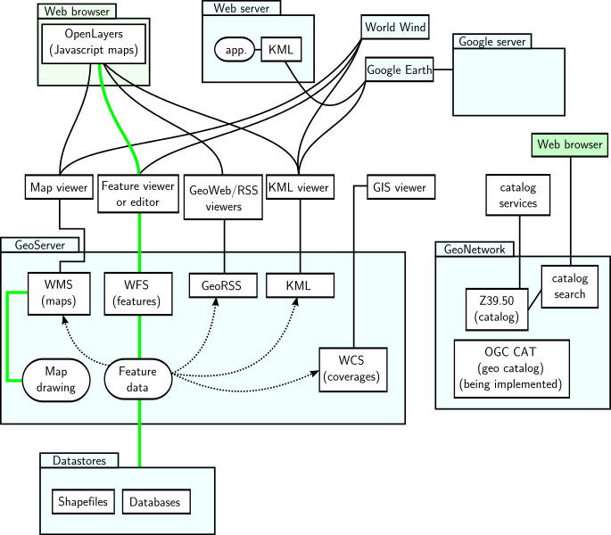
| ការពិពណ៌នា | GeoServer and GeoNetwork with interfaces and applications sketch. Green represents read and write paths. Dotted arrowed line indicates mostly read-only data flow. |
| កាលបរិច្ឆេទ | (UTC) |
| ប្រភព | |
| អ្នកនិពន្ធ |
|
| This is a retouched picture, which means that it has been digitally altered from its original version. Modifications: Made a vector version. The original can be viewed here: GeoServer GeoNetwork with web app.png. Modifications made by Belamp.
|
I, the copyright holder of this work, hereby publish it under the following licenses:
ឯកសារនេះជាប់អាជ្ញាបណ្ឌCreative Commons Attribution-Share Alike 3.0 Unported, 2.5 Generic, 2.0 Generic និង 1.0 Generic។
- អ្នកមានសិទ្ធិ៖
- ចែកចាយ – ថតចំលងនិងចែកចាយស្នាដៃនេះ
- កែច្នៃ – កែច្នៃយកទៅប្រើ
- ក្រោមលក្ខខណ្ឌដូចតទៅនេះ៖
- ភាពជាម្ចាស់កម្មសិទ្ធ – You must give appropriate credit, provide a link to the license, and indicate if changes were made. You may do so in any reasonable manner, but not in any way that suggests the licensor endorses you or your use.
- share alike – If you remix, transform, or build upon the material, you must distribute your contributions under the same or compatible license as the original.

|
រូបភាពនៃទំព័រនេះជាកម្មសិទ្ធិរបស់GNU Free Documentation License។ Version 1.2 ឬក៏ខ្ពស់ជាងនេះត្រូវបានឧបត្ថមគាំទ្រដោយ មូលនិធិសូហ្វវែរដោយឥតគិតថ្លៃ (Free Software Foundation) ដែលមិនមានផ្នែកណាមួយរបស់ប្រភពដើមរួមទាំងអក្សរនៅលើគំរបមុខនិងខ្នង ត្រូវបានផ្លាស់ប្តូរទេ។ ចំពោះផ្នែកដែលមិនអាចផ្លាស់ប្តូរបាន សូមមើលGNU Free Documentation License។ |
You may select the license of your choice.
Original upload log
This image is a derivative work of the following images:
- File:GeoServer_GeoNetwork_with_web_app.png licensed with Cc-by-sa-3.0,2.5,2.0,1.0, GFDL
- 2007-12-07T23:39:23Z SEWilco 698x569 (49691 Bytes) == Summary == {{Information |Description=GeoServer and GeoNetwork with interfaces and applications sketch. Green represents read and write paths. Dotted arrowed line indicates mostly read-only data flow. |Source=self-made |
Uploaded with derivativeFX
ប្រវត្តិឯកសារ
ចុចលើម៉ោងនិងកាលបរិច្ឆេទដើម្បីមើលឯកសារដែលបានផ្ទុកឡើងនៅពេលនោះ។
| ម៉ោងនិងកាលបរិច្ឆេទ | កូនរូបភាព | វិមាត្រ | អ្នកប្រើប្រាស់ | យោបល់ | |
|---|---|---|---|---|---|
| បច្ចុប្បន្ន | ម៉ោង១៩:៣៦ ថ្ងៃសៅរ៍ ទី១០ ខែសីហា ឆ្នាំ២០១៣ | | ៨១៣ × ៧១២ (១០៣គីឡូបៃ) | Sidpatil | Filesize reduced with `scour`. |
| ម៉ោង០៦:៥០ ថ្ងៃសុក្រ ទី៣០ ខែមេសា ឆ្នាំ២០១០ |  | ៨១៣ × ៧១២ (២៦៦គីឡូបៃ) | Andrej Shadura | Fixed fonts issue | |
| ម៉ោង០៦:៤២ ថ្ងៃសុក្រ ទី៣០ ខែមេសា ឆ្នាំ២០១០ |  | ៨១៣ × ៧១២ (២៥០គីឡូបៃ) | Andrej Shadura | {{Information |Description=GeoServer and GeoNetwork with interfaces and applications sketch. Green represents read and write paths. Dotted arrowed line indicates mostly read-only data flow. |Source=*File:GeoServer_GeoNetwork_with_web_app.png |Date |
បម្រើបម្រាស់ឯកសារ
គ្មានទំព័រណាមួយដែលប្រើប្រាស់ឯកសារនេះទេ។
បម្រើបម្រាស់ឯកសារជាសាកល
វីគីដទៃទៀតដូចខាងក្រោមនេះប្រើប្រាស់ឯកសារនេះ៖
- ការប្រើប្រាស់នៅក្នុង ar.wikipedia.org
- ការប្រើប្រាស់នៅក្នុង bn.wikipedia.org
- ការប្រើប្រាស់នៅក្នុង de.wikipedia.org
- ការប្រើប្រាស់នៅក្នុង en.wikipedia.org
- ការប្រើប្រាស់នៅក្នុង es.wikipedia.org
- ការប្រើប្រាស់នៅក្នុង fa.wikipedia.org
- ការប្រើប្រាស់នៅក្នុង fi.wikipedia.org
- ការប្រើប្រាស់នៅក្នុង fr.wikipedia.org
- ការប្រើប្រាស់នៅក្នុង gl.wikipedia.org
- ការប្រើប្រាស់នៅក្នុង hu.wikipedia.org
- ការប្រើប្រាស់នៅក្នុង ig.wikipedia.org
- ការប្រើប្រាស់នៅក្នុង it.wikipedia.org
- ការប្រើប្រាស់នៅក្នុង ja.wikipedia.org
- ការប្រើប្រាស់នៅក្នុង ko.wikipedia.org
- ការប្រើប្រាស់នៅក្នុង ml.wikipedia.org
- ការប្រើប្រាស់នៅក្នុង pl.wikipedia.org
- ការប្រើប្រាស់នៅក្នុង ro.wikipedia.org
- ការប្រើប្រាស់នៅក្នុង ru.wikipedia.org
- ការប្រើប្រាស់នៅក្នុង sr.wikipedia.org
- ការប្រើប្រាស់នៅក្នុង uk.wikipedia.org
- ការប្រើប្រាស់នៅក្នុង vi.wikipedia.org
- ការប្រើប្រាស់នៅក្នុង www.wikidata.org
- ការប្រើប្រាស់នៅក្នុង zh.wikipedia.org