
ឯកសារ:Gz-map2.png
គ្មានភាពម៉ត់ខ្ពស់ជាងនេះទេ។
Gz-map2.png (៣២៨ × ៣៥២ ភីកសែល ទំហំឯកសារ៖ ៨គីឡូបៃ ប្រភេទ MIME៖ image/png)
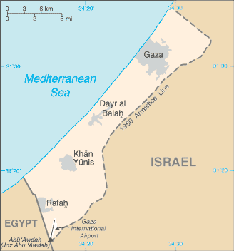
| ការពិពណ៌នា | A map of the Gaza Strip | |||
| កាលបរិច្ឆេទ |
Taken from CIA World Factbook website on 28 August 2006. Please note that this is not the original CIA map; it has been edited to remove the text Israeli-occupied with current status subject to the Israeli-Palestinian Interim Agreement - permanent status to be determined through further negotiation (compare e.g. [1]). |
|||
| ប្រភព | CIA World Factbook | |||
| អ្នកនិពន្ធ | CIA | |||
| ការអនុញ្ញាត (ប្រើឯកសារនេះឡើងវិញ) |
Public domain, as is all content from the CIA factbook
|

ប្រវត្តិឯកសារ
ចុចលើម៉ោងនិងកាលបរិច្ឆេទដើម្បីមើលឯកសារដែលបានផ្ទុកឡើងនៅពេលនោះ។
| ម៉ោងនិងកាលបរិច្ឆេទ | កូនរូបភាព | វិមាត្រ | អ្នកប្រើប្រាស់ | យោបល់ | |
|---|---|---|---|---|---|
| បច្ចុប្បន្ន | ម៉ោង១៣:១៦ ថ្ងៃព្រហស្បតិ៍ ទី២០ ខែឧសភា ឆ្នាំ២០២១ | | ៣២៨ × ៣៥២ (៨គីឡូបៃ) | Jul059 | Lossless file size reduction |
| ម៉ោង១៦:៣៦ ថ្ងៃច័ន្ទ ទី០៩ ខែកក្កដា ឆ្នាំ២០១២ |  | ៣២៨ × ៣៥២ (២៥គីឡូបៃ) | Quite vivid blur | Distinguishable colours | |
| ម៉ោង០២:២៩ ថ្ងៃអាទិត្យ ទី០២ ខែធ្នូ ឆ្នាំ២០០៧ |  | ៣២៨ × ៣៥២ (១៥គីឡូបៃ) | Kordas | Updated and fixed image | |
| ម៉ោង០២:៥៩ ថ្ងៃអាទិត្យ ទី២៥ ខែមីនា ឆ្នាំ២០០៧ |  | ៣២៨ × ៣៥២ (២៦គីឡូបៃ) | Tewfik | {{Information |Description=A map of the Gaza Strip |Source=[https://www.cia.gov/cia/publications/factbook/geos/gz.html CIA World Factbook] |Date=12 April |Author=CIA |Permission= Public domain, as is all content from the CIA factbook {{PD-USGov-CIA-W |
បម្រើបម្រាស់ឯកសារ
ទំព័រ ខាងក្រោមប្រើប្រាស់ឯកសារនេះ ៖
បម្រើបម្រាស់ឯកសារជាសាកល
វីគីដទៃទៀតដូចខាងក្រោមនេះប្រើប្រាស់ឯកសារនេះ៖
- ការប្រើប្រាស់នៅក្នុង am.wikipedia.org
- ការប្រើប្រាស់នៅក្នុង ast.wikipedia.org
- ការប្រើប្រាស់នៅក្នុង azb.wikipedia.org
- ការប្រើប្រាស់នៅក្នុង cy.wikipedia.org
- ការប្រើប្រាស់នៅក្នុង de.wikinews.org
- ការប្រើប្រាស់នៅក្នុង en.wikipedia.org
- History of the State of Palestine
- User:Kzzl/Gzzl/talk
- List of cities in the Gaza Strip
- Wikipedia:Village pump (policy)/Archive 27
- Wikipedia:Wikipedia Signpost/2014-08-06/Traffic report
- Wikipedia:Wikipedia Signpost/Single/2014-08-06
- Wikipedia:Top 25 Report/July 27 to August 2, 2014
- Wikipedia:Top 25 Report/August 3 to 9, 2014
- Wikipedia:Top 25 Report/May 16 to 22, 2021
- ការប្រើប្រាស់នៅក្នុង en.wikinews.org
- ការប្រើប្រាស់នៅក្នុង en.wikiquote.org
- ការប្រើប្រាស់នៅក្នុង en.wiktionary.org
- ការប្រើប្រាស់នៅក្នុង es.wikipedia.org
- ការប្រើប្រាស់នៅក្នុង es.wikinews.org
- ការប្រើប្រាស់នៅក្នុង fa.wikipedia.org
- ការប្រើប្រាស់នៅក្នុង ff.wikipedia.org
- ការប្រើប្រាស់នៅក្នុង fo.wikipedia.org
- ការប្រើប្រាស់នៅក្នុង fy.wikipedia.org
- ការប្រើប្រាស់នៅក្នុង hy.wikipedia.org
- ការប្រើប្រាស់នៅក្នុង id.wikipedia.org
- ការប្រើប្រាស់នៅក្នុង incubator.wikimedia.org
- ការប្រើប្រាស់នៅក្នុង io.wikipedia.org
- ការប្រើប្រាស់នៅក្នុង it.wikipedia.org
- ការប្រើប្រាស់នៅក្នុង jv.wikipedia.org
- ការប្រើប្រាស់នៅក្នុង ka.wikipedia.org
- ការប្រើប្រាស់នៅក្នុង lmo.wikipedia.org
- ការប្រើប្រាស់នៅក្នុង lt.wiktionary.org
- ការប្រើប្រាស់នៅក្នុង mai.wikipedia.org
- ការប្រើប្រាស់នៅក្នុង mg.wikipedia.org
- ការប្រើប្រាស់នៅក្នុង mk.wikipedia.org
- ការប្រើប្រាស់នៅក្នុង ne.wikipedia.org
- ការប្រើប្រាស់នៅក្នុង sco.wikipedia.org
- ការប្រើប្រាស់នៅក្នុង sk.wikipedia.org
- ការប្រើប្រាស់នៅក្នុង sq.wikipedia.org
- ការប្រើប្រាស់នៅក្នុង ta.wikipedia.org
- ការប្រើប្រាស់នៅក្នុង th.wikipedia.org
- ការប្រើប្រាស់នៅក្នុង ur.wikipedia.org
- ការប្រើប្រាស់នៅក្នុង wa.wikipedia.org
- ការប្រើប្រាស់នៅក្នុង wuu.wikipedia.org
View more global usage of this file.