
ឯកសារ:History of Korea-476.PNG

ទំហំរបស់ការមើលមុននេះ: ៥០៧ × ៥៩៩ ភីកសែ។ ភាពម៉ត់ផ្សេងទៀត៖ ២០៣ × ២៤០ ភីកសែ | ៤០៦ × ៤៨០ ភីកសែ | ៩៧០ × ១១៤៦ ភីកសែ។
រូបភាពដើម (៩៧០ × ១១៤៦ ភីកសែល ទំហំឯកសារ៖ ៨៦៦គីឡូបៃ ប្រភេទ MIME៖ image/png)
ចំណារពន្យល់
| ការពិពណ៌នា |
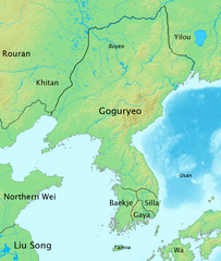
English: The map of history of Korea in 476, the moment of greatest territorial expansion of Goguryeo.
한국어: 한국사 지도 - 476년, 고구려 전성기때의 지도. |
| កាលបរិច្ឆេទ | |
| ប្រភព | ការងារផ្ទាល់របស់អ្នកផ្ទុកឡើង |
| អ្នកនិពន្ធ | Myself |
ការដាក់អាជ្ញាប័ណ្ណ
I, the copyright holder of this work, hereby publish it under the following license:
ឯកសារនេះជាប់អាជ្ញាបណ្ឌCreative Commons Attribution-Share Alike 3.0 Unported។
- អ្នកមានសិទ្ធិ៖
- ចែកចាយ – ថតចំលងនិងចែកចាយស្នាដៃនេះ
- កែច្នៃ – កែច្នៃយកទៅប្រើ
- ក្រោមលក្ខខណ្ឌដូចតទៅនេះ៖
- ភាពជាម្ចាស់កម្មសិទ្ធ – You must give appropriate credit, provide a link to the license, and indicate if changes were made. You may do so in any reasonable manner, but not in any way that suggests the licensor endorses you or your use.
- share alike – If you remix, transform, or build upon the material, you must distribute your contributions under the same or compatible license as the original.
ប្រវត្តិឯកសារ
ចុចលើម៉ោងនិងកាលបរិច្ឆេទដើម្បីមើលឯកសារដែលបានផ្ទុកឡើងនៅពេលនោះ។
| ម៉ោងនិងកាលបរិច្ឆេទ | កូនរូបភាព | វិមាត្រ | អ្នកប្រើប្រាស់ | យោបល់ | |
|---|---|---|---|---|---|
| បច្ចុប្បន្ន | ម៉ោង០៨:៥១ ថ្ងៃសៅរ៍ ទី០៤ ខែតុលា ឆ្នាំ២០០៨ | | ៩៧០ × ១១៤៦ (៨៦៦គីឡូបៃ) | Historiographer~commonswiki | {{Information |Description= |Source= |Date= |Author= |Permission= |other_versions= }} |
| ម៉ោង០៥:៣៧ ថ្ងៃព្រហស្បតិ៍ ទី០៣ ខែកក្កដា ឆ្នាំ២០០៨ |  | ៩៧០ × ១១៤៦ (៥៧១គីឡូបៃ) | Historiographer~commonswiki | {{Information |Description= |Source= |Date= |Author= |Permission= |other_versions= }} | |
| ម៉ោង១៤:៤៨ ថ្ងៃសៅរ៍ ទី១៤ ខែមិថុនា ឆ្នាំ២០០៨ |  | ៩៧០ × ១១៤៦ (៨៧៣គីឡូបៃ) | Historiographer~commonswiki | {{Information |Description= |Source= |Date= |Author= |Permission= |other_versions= }} | |
| ម៉ោង១៤:៤៦ ថ្ងៃសៅរ៍ ទី១៤ ខែមិថុនា ឆ្នាំ២០០៨ |  | ៩៧០ × ១១៤៦ (៥៦៨គីឡូបៃ) | Historiographer~commonswiki | {{Information |Description= |Source= |Date= |Author= |Permission= |other_versions= }} | |
| ម៉ោង១៣:៤៧ ថ្ងៃព្រហស្បតិ៍ ទី១២ ខែមិថុនា ឆ្នាំ២០០៨ |  | ៩៧០ × ១១៤៦ (៨៧៤គីឡូបៃ) | Historiographer~commonswiki | {{Information |Description={{en|1=The map of history of Korea in 476, The greatest territory expansion of Goguryeo. }} {{ko|1=한국사 지도 - 476년, 고구려 전성기때의 지도.}} |Source=Self-made |Author=Myself |Date=2008-06-10 |Permission= |ot |
បម្រើបម្រាស់ឯកសារ
ទំព័រ ខាងក្រោមប្រើប្រាស់ឯកសារនេះ ៖
បម្រើបម្រាស់ឯកសារជាសាកល
វីគីដទៃទៀតដូចខាងក្រោមនេះប្រើប្រាស់ឯកសារនេះ៖
- ការប្រើប្រាស់នៅក្នុង ang.wikipedia.org
- ការប្រើប្រាស់នៅក្នុង ast.wikipedia.org
- ការប្រើប្រាស់នៅក្នុង azb.wikipedia.org
- ការប្រើប្រាស់នៅក្នុង az.wikipedia.org
- ការប្រើប្រាស់នៅក្នុង ba.wikipedia.org
- ការប្រើប្រាស់នៅក្នុង be-tarask.wikipedia.org
- ការប្រើប្រាស់នៅក្នុង be.wikipedia.org
- ការប្រើប្រាស់នៅក្នុង br.wikipedia.org
- ការប្រើប្រាស់នៅក្នុង ca.wikipedia.org
- ការប្រើប្រាស់នៅក្នុង cdo.wikipedia.org
- ការប្រើប្រាស់នៅក្នុង ckb.wikipedia.org
- ការប្រើប្រាស់នៅក្នុង cs.wikipedia.org
- ការប្រើប្រាស់នៅក្នុង cy.wikipedia.org
- ការប្រើប្រាស់នៅក្នុង da.wikipedia.org
- ការប្រើប្រាស់នៅក្នុង da.wikibooks.org
- ការប្រើប្រាស់នៅក្នុង de.wikipedia.org
- ការប្រើប្រាស់នៅក្នុង en.wikipedia.org
View more global usage of this file.