
ឯកសារ:Iran location map.svg

Size of this PNG preview of this SVG file: ៦៧២ × ៦០០ ភីកសែ. ភាពម៉ត់ផ្សេងទៀត៖ ២៦៩ × ២៤០ ភីកសែ | ៥៣៨ × ៤៨០ ភីកសែ | ៨៦១ × ៧៦៨ ភីកសែ | ១១៤៧ × ១០២៤ ភីកសែ | ២២៩៥ × ២០៤៨ ភីកសែ | ១២០០ × ១០៧១ ភីកសែ។
រូបភាពដើម (ឯកសារប្រភេទSVG ១២០០ × ១០៧១ ភីកសែល ទំហំឯកសារ៖ ២៩៩គីឡូបៃ)
ចំណារពន្យល់
| ការពិពណ៌នា |
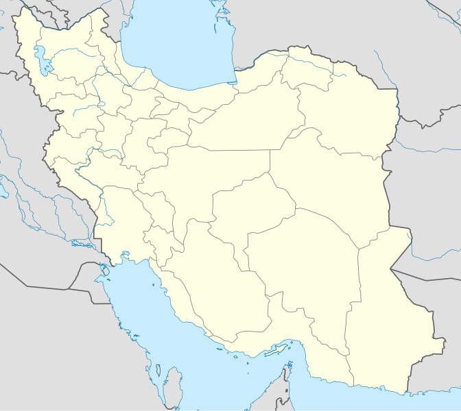
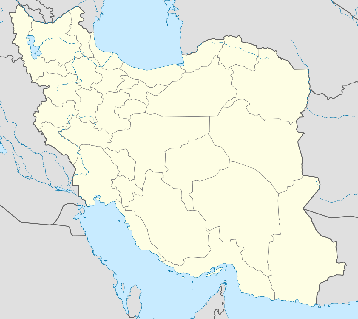
English: Location map of Iran.
Equirectangular projection. Stretched by 118.0%. Geographic limits of the map: * N: 40.0° N * S: 24.5° N * W: 43.5° E * E: 64.0° EMade with Natural Earth. Free vector and raster map data @ naturalearthdata.com. |
| កាលបរិច្ឆេទ | |
| ប្រភព | ការងារផ្ទាល់របស់អ្នកផ្ទុកឡើង |
| អ្នកនិពន្ធ | Uwe Dedering |
| ទំរង់ផ្សេងទៀត |
Derivative works of this file:
|
| SVG genesis | រូបភាពក្រាភិកវ៉ិចទ័រនេះត្រូវបានបង្កើតឡើងដោយប្រើ Adobe Illustrator, and with Inkscape. |

ការដាក់អាជ្ញាប័ណ្ណ
I, the copyright holder of this work, hereby publish it under the following licenses:
ឯកសារនេះជាប់អាជ្ញាបណ្ឌCreative Commons Attribution-Share Alike 3.0 Unported។
- អ្នកមានសិទ្ធិ៖
- ចែកចាយ – ថតចំលងនិងចែកចាយស្នាដៃនេះ
- កែច្នៃ – កែច្នៃយកទៅប្រើ
- ក្រោមលក្ខខណ្ឌដូចតទៅនេះ៖
- ភាពជាម្ចាស់កម្មសិទ្ធ – You must give appropriate credit, provide a link to the license, and indicate if changes were made. You may do so in any reasonable manner, but not in any way that suggests the licensor endorses you or your use.
- share alike – If you remix, transform, or build upon the material, you must distribute your contributions under the same or compatible license as the original.

|
រូបភាពនៃទំព័រនេះជាកម្មសិទ្ធិរបស់GNU Free Documentation License។ Version 1.2 ឬក៏ខ្ពស់ជាងនេះត្រូវបានឧបត្ថមគាំទ្រដោយ មូលនិធិសូហ្វវែរដោយឥតគិតថ្លៃ (Free Software Foundation) ដែលមិនមានផ្នែកណាមួយរបស់ប្រភពដើមរួមទាំងអក្សរនៅលើគំរបមុខនិងខ្នង ត្រូវបានផ្លាស់ប្តូរទេ។ ចំពោះផ្នែកដែលមិនអាចផ្លាស់ប្តូរបាន សូមមើលGNU Free Documentation License។ |
You may select the license of your choice.
ប្រវត្តិឯកសារ
ចុចលើម៉ោងនិងកាលបរិច្ឆេទដើម្បីមើលឯកសារដែលបានផ្ទុកឡើងនៅពេលនោះ។
| ម៉ោងនិងកាលបរិច្ឆេទ | កូនរូបភាព | វិមាត្រ | អ្នកប្រើប្រាស់ | យោបល់ | |
|---|---|---|---|---|---|
| បច្ចុប្បន្ន | ម៉ោង០៧:៥៩ ថ្ងៃអង្គារ ទី២២ ខែតុលា ឆ្នាំ២០១៣ | | ១២០០ × ១០៧១ (២៩៩គីឡូបៃ) | NordNordWest | Reverted to version as of 17:55, 15 April 2013; no reason for change given |
| ម៉ោង១៣:៤៤ ថ្ងៃច័ន្ទ ទី២១ ខែតុលា ឆ្នាំ២០១៣ |  | ១២០០ × ១០៧១ (៦៤០គីឡូបៃ) | Ekivalan | Reverted to version as of 17:38, 12 April 2013 | |
| ម៉ោង១៣:៤៣ ថ្ងៃច័ន្ទ ទី២១ ខែតុលា ឆ្នាំ២០១៣ |  | ១២០០ × ១០៧១ (៦៤០គីឡូបៃ) | Ekivalan | Reverted to version as of 17:38, 12 April 2013 | |
| ម៉ោង១៧:៥៥ ថ្ងៃច័ន្ទ ទី១៥ ខែមេសា ឆ្នាំ២០១៣ |  | ១២០០ × ១០៧១ (២៩៩គីឡូបៃ) | NordNordWest | according to http://images.persianblog.ir/516041_B0b76ypr.jpg + Tabas -> South Khorasan province | |
| ម៉ោង១៧:៤០ ថ្ងៃសុក្រ ទី១២ ខែមេសា ឆ្នាំ២០១៣ |  | ១២០០ × ១០៧១ (៦៤០គីឡូបៃ) | Yamaha5 | Reverted to version as of 20:08, 11 July 2010 | |
| ម៉ោង១៧:៣៨ ថ្ងៃសុក្រ ទី១២ ខែមេសា ឆ្នាំ២០១៣ |  | ១២០០ × ១០៧១ (៦៤០គីឡូបៃ) | Yamaha5 | Reverted to version as of 20:08, 11 July 2010 in all maps khorasan is like past! | |
| ម៉ោង១១:៣០ ថ្ងៃអាទិត្យ ទី១៧ ខែមីនា ឆ្នាំ២០១៣ |  | ១២០០ × ១០៧១ (២៩៤គីឡូបៃ) | NordNordWest | upd | |
| ម៉ោង២០:០៨ ថ្ងៃអាទិត្យ ទី១១ ខែកក្កដា ឆ្នាំ២០១០ |  | ១២០០ × ១០៧១ (៦៤០គីឡូបៃ) | Uwe Dedering | 31. province Alborz | |
| ម៉ោង១៧:៤៤ ថ្ងៃព្រហស្បតិ៍ ទី១៨ ខែកុម្ភៈ ឆ្នាំ២០១០ |  | ១២០០ × ១០៧១ (៧០៥គីឡូបៃ) | Uwe Dedering | Bahrain above water, no disputed countries | |
| ម៉ោង១៣:០០ ថ្ងៃព្រហស្បតិ៍ ទី១៨ ខែកុម្ភៈ ឆ្នាំ២០១០ |  | ១២០០ × ១០៧១ (៧០៩គីឡូបៃ) | Uwe Dedering | {{Information |Description={{en|1=Location map of Iran. Equirectangular projection. Strechted by 118.0%. Geographic limits of the map: * N: 40.0° N * S: 24.5° N * W: 43.5° E * E: 64.0° E Made with Natural Earth. Free vector and raster map data @ |
បម្រើបម្រាស់ឯកសារ
ទំព័រ ខាងក្រោមប្រើប្រាស់ឯកសារនេះ ៖
បម្រើបម្រាស់ឯកសារជាសាកល
វីគីដទៃទៀតដូចខាងក្រោមនេះប្រើប្រាស់ឯកសារនេះ៖
- ការប្រើប្រាស់នៅក្នុង af.wikipedia.org
- ការប្រើប្រាស់នៅក្នុង als.wikipedia.org
- ការប្រើប្រាស់នៅក្នុង an.wikipedia.org
- ការប្រើប្រាស់នៅក្នុង ar.wikipedia.org
- محمد بن إسماعيل البخاري
- طهران
- صحيح مسلم
- محافظات إيران
- فخر الدين الرازي
- كأس آسيا 1968
- كأس آسيا 1976
- مسلم بن الحجاج
- قالب:خريطة مواقع إیران
- مشهد
- زلزال بم 2003
- تفجيرات زاهدان 2010
- زلزال طبس 1978
- بطولة آسيا للناشئين تحت 16 عاما 2012
- قائمة المفكرين المسيحيين في العلم
- مرتضى الأنصاري
- زلزال تبريز 2012
- شعيطة (رامشير)
View more global usage of this file.