
ឯកសារ:Large map of Hokkaido within Japan.png

ទំហំរបស់ការមើលមុននេះ: ៧៧៥ × ៦០០ ភីកសែ។ ភាពម៉ត់ផ្សេងទៀត៖ ៣១០ × ២៤០ ភីកសែ | ៦២០ × ៤៨០ ភីកសែ | ៩៩២ × ៧៦៨ ភីកសែ | ១២៨០ × ៩៩១ ភីកសែ | ២៥៦០ × ១៩៨២ ភីកសែ | ៣១០០ × ២៤០០ ភីកសែ។
រូបភាពដើម (៣១០០ × ២៤០០ ភីកសែល ទំហំឯកសារ៖ ១.៤១មេកាបៃ ប្រភេទ MIME៖ image/png)
ចំណារពន្យល់
| ការពិពណ៌នា |
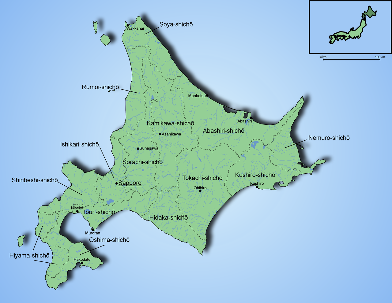
English: This image is created with Inkscape and Paint Shop Pro by Ningyou. Based on several maps found from internet and mapbooks.
The Map is showing rivers and lakes of Hokkaido, the biggest cities and the borders of subprefectures. |
| កាលបរិច្ឆេទ | ២ ខែមករា ២០០៦ (original upload date) |
| ប្រភព | ការងារផ្ទាល់របស់អ្នកផ្ទុកឡើង |
| អ្នកនិពន្ធ | Ningyou |
ការដាក់អាជ្ញាប័ណ្ណ
| I, the copyright holder of this work, release this work into the public domain. This applies worldwide. In some countries this may not be legally possible; if so: I grant anyone the right to use this work for any purpose, without any conditions, unless such conditions are required by law. |
ប្រវត្តិឯកសារ
ចុចលើម៉ោងនិងកាលបរិច្ឆេទដើម្បីមើលឯកសារដែលបានផ្ទុកឡើងនៅពេលនោះ។
| ម៉ោងនិងកាលបរិច្ឆេទ | កូនរូបភាព | វិមាត្រ | អ្នកប្រើប្រាស់ | យោបល់ | |
|---|---|---|---|---|---|
| បច្ចុប្បន្ន | ម៉ោង១៨:០៥ ថ្ងៃច័ន្ទ ទី០២ ខែមករា ឆ្នាំ២០០៦ | | ៣១០០ × ២៤០០ (១.៤១មេកាបៃ) | Ningyou | The image is created with Inkscape and Paint Shop Pro by Fi:Ningyou. Based on several maps found from internet and mapbooks. Category:Maps of Japan |
បម្រើបម្រាស់ឯកសារ
ទំព័រ ខាងក្រោមប្រើប្រាស់ឯកសារនេះ ៖
បម្រើបម្រាស់ឯកសារជាសាកល
វីគីដទៃទៀតដូចខាងក្រោមនេះប្រើប្រាស់ឯកសារនេះ៖
- ការប្រើប្រាស់នៅក្នុង az.wikipedia.org
- ការប្រើប្រាស់នៅក្នុង be.wikipedia.org
- ការប្រើប្រាស់នៅក្នុង da.wikipedia.org
- ការប្រើប្រាស់នៅក្នុង de.wikipedia.org
- ការប្រើប្រាស់នៅក្នុង el.wikipedia.org
- ការប្រើប្រាស់នៅក្នុង en.wikipedia.org
- ការប្រើប្រាស់នៅក្នុង et.wikipedia.org
- ការប្រើប្រាស់នៅក្នុង eu.wikipedia.org
- ការប្រើប្រាស់នៅក្នុង fi.wikipedia.org
- ការប្រើប្រាស់នៅក្នុង fr.wikipedia.org
- ការប្រើប្រាស់នៅក្នុង gl.wikipedia.org
- ការប្រើប្រាស់នៅក្នុង hu.wikipedia.org
- ការប្រើប្រាស់នៅក្នុង id.wikipedia.org
- ការប្រើប្រាស់នៅក្នុង it.wikipedia.org
- ការប្រើប្រាស់នៅក្នុង lt.wikipedia.org
- ការប្រើប្រាស់នៅក្នុង nl.wikipedia.org
- ការប្រើប្រាស់នៅក្នុង no.wikipedia.org
- ការប្រើប្រាស់នៅក្នុង oc.wikipedia.org
- ការប្រើប្រាស់នៅក្នុង pam.wikipedia.org
- ការប្រើប្រាស់នៅក្នុង pl.wikipedia.org
- ការប្រើប្រាស់នៅក្នុង pnb.wikipedia.org
- ការប្រើប្រាស់នៅក្នុង ru.wikipedia.org
- ការប្រើប្រាស់នៅក្នុង th.wikipedia.org
- ការប្រើប្រាស់នៅក្នុង uk.wikipedia.org
- ការប្រើប្រាស់នៅក្នុង vi.wikipedia.org
- ការប្រើប្រាស់នៅក្នុង xmf.wikipedia.org