
ឯកសារ:Majapahit Empire.svg

Size of this PNG preview of this SVG file: ៥១២ × ២៩៧ ភីកសែ. ភាពម៉ត់ផ្សេងទៀត៖ ៣២០ × ១៨៦ ភីកសែ | ៦៤០ × ៣៧១ ភីកសែ | ១០២៤ × ៥៩៤ ភីកសែ | ១២៨០ × ៧៤៣ ភីកសែ | ២៥៦០ × ១៤៨៥ ភីកសែ។
រូបភាពដើម (ឯកសារប្រភេទSVG ៥១២ × ២៩៧ ភីកសែល ទំហំឯកសារ៖ ៥២៤គីឡូបៃ)
ចំណារពន្យល់
| ការពិពណ៌នា |
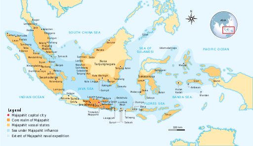
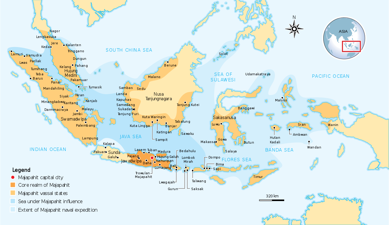
English: The Nusantara Archipelago during the height of Majapahit Empire in XIV century.
The red dot is Trowulan; Majapahit capital city. The dark orange area is core realm of Majapahit on eastern part of Java. The light orange area is vassal states of Majapahit mentioned in Nagarakretagama. The pale yellow is outer realm or independent states from Majapahit. The dark cyan is the sea area under influence or effective control of Majapahit. The light cyan is the extent of Majapahit naval expedition. |
||
| កាលបរិច្ឆេទ | |||
| ប្រភព | Own work by uploader, see #References for references used creating the map. | ||
| អ្នកនិពន្ធ | Gunawan Kartapranata | ||
| ការអនុញ្ញាត (ប្រើឯកសារនេះឡើងវិញ) |
I, the copyright holder of this work, hereby publish it under the following licenses: ឯកសារនេះជាប់អាជ្ញាបណ្ឌCreative Commons Attribution-Share Alike 3.0 Unported។
You may select the license of your choice. |
||
| ទំរង់ផ្សេងទៀត |
[] []
|


|
ហ្វាល់ SVG នេះបង្កប់ឃ្លាជាអក្សរដែលអាចឲ្យអ្នកងាយស្រួលបកប្រែជាភាសារបស់អ្នក។ ព័ត៌មានលំអិត (ជាភាសាអង់គ្លេស) ចំពោះរូបភាព SVG អ្នកអាចប្រើ[toolforge:svgtranslate/File:Majapahit_Empire.svglink ទំព័រនេះ] ដើម្បីបកប្រែវាជាភាសារបស់អ្នក។ |
References
Resources used to create the map:
- (២១ ខែមិថុនា ២០០៧) Majapahit, Kompas Daily, Jakarta Indonesia
- Latif, Chalid; Irwin Lay , ed. (១៩៩៧) Atlas Sejarah Indonesia dan Dunia (Historical Atlas of Indonesia and World), PT Pembina Peraga, Jakarta
- (indonesian) IPS Terpadu (Sosiologi, Geografi, Ekonomi, Sejarah), PT Grafindo Media Pratama, p. 219 ISBN: 9789797583378.
ប្រវត្តិឯកសារ
ចុចលើម៉ោងនិងកាលបរិច្ឆេទដើម្បីមើលឯកសារដែលបានផ្ទុកឡើងនៅពេលនោះ។
| ម៉ោងនិងកាលបរិច្ឆេទ | កូនរូបភាព | វិមាត្រ | អ្នកប្រើប្រាស់ | យោបល់ | |
|---|---|---|---|---|---|
| បច្ចុប្បន្ន | ម៉ោង១៣:០៧ ថ្ងៃសុក្រ ទី២៨ ខែតុលា ឆ្នាំ២០១៦ | | ៥១២ × ២៩៧ (៥២៤គីឡូបៃ) | Gunkarta | Correction on Luwu location |
| ម៉ោង១០:១៣ ថ្ងៃព្រហស្បតិ៍ ទី០៥ ខែវិច្ឆិកា ឆ្នាំ២០០៩ |  | ៧៨១ × ៤៥៧ (៥២៥គីឡូបៃ) | Gunkarta | Corrected the location of Malano in northeast coast of Borneo and Wanin/Onin in Papua (today Fak-fak). | |
| ម៉ោង១៥:៤៣ ថ្ងៃច័ន្ទ ទី១០ ខែសីហា ឆ្នាំ២០០៩ |  | ៧៨១ × ៤៥៧ (៥២៥គីឡូបៃ) | Gunkarta | Crop the map again | |
| ម៉ោង១៥:៣៧ ថ្ងៃច័ន្ទ ទី១០ ខែសីហា ឆ្នាំ២០០៩ |  | ៧៨១ × ៤៦៣ (៥២៩គីឡូបៃ) | Gunkarta | Crop the map | |
| ម៉ោង១៥:២៧ ថ្ងៃច័ន្ទ ទី១០ ខែសីហា ឆ្នាំ២០០៩ |  | ៩៨៦ × ៦១០ (៥៨២គីឡូបៃ) | Gunkarta | {{Information |Description={{en|1=The Nusantara Archipelago during the height of Majapahit Empire in XIV century. 1. The red dot is Trowulan; Majapahit capital city 2. The dark orange area is core realm of Majapahit on eastern part of Java 3. The light o |
បម្រើបម្រាស់ឯកសារ
ទំព័រ ខាងក្រោមប្រើប្រាស់ឯកសារនេះ ៖
បម្រើបម្រាស់ឯកសារជាសាកល
វីគីដទៃទៀតដូចខាងក្រោមនេះប្រើប្រាស់ឯកសារនេះ៖
- ការប្រើប្រាស់នៅក្នុង ar.wikipedia.org
- ការប្រើប្រាស់នៅក្នុង arz.wikipedia.org
- ការប្រើប្រាស់នៅក្នុង ast.wikipedia.org
- ការប្រើប្រាស់នៅក្នុង ba.wikipedia.org
- ការប្រើប្រាស់នៅក្នុង bcl.wikipedia.org
- ការប្រើប្រាស់នៅក្នុង bg.wikipedia.org
- ការប្រើប្រាស់នៅក្នុង bn.wikipedia.org
- ការប្រើប្រាស់នៅក្នុង ca.wikipedia.org
- ការប្រើប្រាស់នៅក្នុង cs.wikipedia.org
- ការប្រើប្រាស់នៅក្នុង de.wikipedia.org
- ការប្រើប្រាស់នៅក្នុង en.wikipedia.org
- ការប្រើប្រាស់នៅក្នុង eo.wikipedia.org
- ការប្រើប្រាស់នៅក្នុង eu.wikipedia.org
- ការប្រើប្រាស់នៅក្នុង fa.wikipedia.org
- ការប្រើប្រាស់នៅក្នុង fi.wikipedia.org
- ការប្រើប្រាស់នៅក្នុង fr.wikipedia.org
- ការប្រើប្រាស់នៅក្នុង gl.wikipedia.org
- ការប្រើប្រាស់នៅក្នុង he.wikipedia.org
- ការប្រើប្រាស់នៅក្នុង hi.wikipedia.org
- ការប្រើប្រាស់នៅក្នុង id.wikipedia.org
- ការប្រើប្រាស់នៅក្នុង id.wikisource.org
- ការប្រើប្រាស់នៅក្នុង id.wiktionary.org
- ការប្រើប្រាស់នៅក្នុង it.wikipedia.org
- ការប្រើប្រាស់នៅក្នុង ja.wikipedia.org
- ការប្រើប្រាស់នៅក្នុង ko.wikipedia.org
- ការប្រើប្រាស់នៅក្នុង lt.wikipedia.org
- ការប្រើប្រាស់នៅក្នុង min.wikipedia.org
- ការប្រើប្រាស់នៅក្នុង ml.wikipedia.org
- ការប្រើប្រាស់នៅក្នុង mr.wikipedia.org
- ការប្រើប្រាស់នៅក្នុង ms.wikipedia.org
- ការប្រើប្រាស់នៅក្នុង mt.wikipedia.org
- ការប្រើប្រាស់នៅក្នុង ne.wikipedia.org
- ការប្រើប្រាស់នៅក្នុង nl.wikipedia.org
View more global usage of this file.