
ឯកសារ:Map of Japan with highlight on 46 Kagoshima prefecture.svg

Size of this PNG preview of this SVG file: ៦០០ × ៦០០ ភីកសែ. ភាពម៉ត់ផ្សេងទៀត៖ ២៤០ × ២៤០ ភីកសែ | ៤៨០ × ៤៨០ ភីកសែ | ៧៦៨ × ៧៦៨ ភីកសែ | ១០២៤ × ១០២៤ ភីកសែ | ២០៤៨ × ២០៤៨ ភីកសែ។
រូបភាពដើម (ឯកសារប្រភេទSVG ១០២៤ × ១០២៤ ភីកសែល ទំហំឯកសារ៖ ១៥គីឡូបៃ)
| ការពិពណ៌នា |
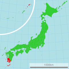
日本語: 鹿児島県の位置図
English: Map of Japan with highlight on Kagoshima-ken |
||||||||
| ប្រភព | 国土交通省 国土数値情報(行政区域) | ||||||||
| អ្នកនិពន្ធ | Lincun | ||||||||
| ការអនុញ្ញាត (ប្រើឯកសារនេះឡើងវិញ) |
|

Original upload log
| date/time | username | resolution | size | edit summary |
|---|---|---|---|---|
| 16:48, 2 March 2007 | User:Lincun | 1,024×1,024 | 15 KB | <span class="comment">({{都道府県地図情報 |都道府県=鹿児島県 |都道府県Latin=Kagoshima-ken }} )</span> |
ប្រវត្តិឯកសារ
ចុចលើម៉ោងនិងកាលបរិច្ឆេទដើម្បីមើលឯកសារដែលបានផ្ទុកឡើងនៅពេលនោះ។
| ម៉ោងនិងកាលបរិច្ឆេទ | កូនរូបភាព | វិមាត្រ | អ្នកប្រើប្រាស់ | យោបល់ | |
|---|---|---|---|---|---|
| បច្ចុប្បន្ន | ម៉ោង០០:៥៥ ថ្ងៃពុធ ទី១៦ ខែមីនា ឆ្នាំ២០១១ | | ១០២៤ × ១០២៤ (១៥គីឡូបៃ) | TAKASUGI Shinji | color changes for a better contrast: lightgreen → limegreen deeppink → red |
| ម៉ោង០២:២២ ថ្ងៃច័ន្ទ ទី២១ ខែមេសា ឆ្នាំ២០០៨ |  | ១០២៤ × ១០២៤ (១៥គីឡូបៃ) | BetacommandBot | move approved by: User:LERK This image was moved from Image:Map of Japan with highlight on 46 Kagoshima 鹿児島県.svg {{User:Lincun/都道府県地図情報 |都道府県=鹿児島県 |都道府県Latin=Kagoshima-ken }} [[Category:Maps of |
បម្រើបម្រាស់ឯកសារ
ទំព័រ ខាងក្រោមប្រើប្រាស់ឯកសារនេះ ៖
បម្រើបម្រាស់ឯកសារជាសាកល
វីគីដទៃទៀតដូចខាងក្រោមនេះប្រើប្រាស់ឯកសារនេះ៖
- ការប្រើប្រាស់នៅក្នុង ace.wikipedia.org
- ការប្រើប្រាស់នៅក្នុង az.wikipedia.org
- ការប្រើប្រាស់នៅក្នុង bat-smg.wikipedia.org
- ការប្រើប្រាស់នៅក្នុង bg.wikipedia.org
- ការប្រើប្រាស់នៅក្នុង bn.wikipedia.org
- ការប្រើប្រាស់នៅក្នុង cdo.wikipedia.org
- ការប្រើប្រាស់នៅក្នុង cy.wikipedia.org
- ការប្រើប្រាស់នៅក្នុង en.wikipedia.org
- ការប្រើប្រាស់នៅក្នុង eo.wikipedia.org
- ការប្រើប្រាស់នៅក្នុង eu.wikipedia.org
- ការប្រើប្រាស់នៅក្នុង fa.wikipedia.org
- ការប្រើប្រាស់នៅក្នុង fr.wikipedia.org
- ការប្រើប្រាស់នៅក្នុង hak.wikipedia.org
- ការប្រើប្រាស់នៅក្នុង hr.wikipedia.org
- ការប្រើប្រាស់នៅក្នុង hu.wikipedia.org
- ការប្រើប្រាស់នៅក្នុង id.wikipedia.org
- ការប្រើប្រាស់នៅក្នុង ilo.wikipedia.org
- ការប្រើប្រាស់នៅក្នុង ja.wikipedia.org
- ការប្រើប្រាស់នៅក្នុង jv.wikipedia.org
- ការប្រើប្រាស់នៅក្នុង ka.wikipedia.org
- ការប្រើប្រាស់នៅក្នុង ko.wikipedia.org
- ការប្រើប្រាស់នៅក្នុង lt.wikipedia.org
- ការប្រើប្រាស់នៅក្នុង mk.wikipedia.org
- ការប្រើប្រាស់នៅក្នុង mr.wikipedia.org
- ការប្រើប្រាស់នៅក្នុង ms.wikipedia.org
- ការប្រើប្រាស់នៅក្នុង nov.wikipedia.org
- ការប្រើប្រាស់នៅក្នុង no.wikipedia.org
- ការប្រើប្រាស់នៅក្នុង pam.wikipedia.org
- ការប្រើប្រាស់នៅក្នុង pl.wikipedia.org
- ការប្រើប្រាស់នៅក្នុង pnb.wikipedia.org
- ការប្រើប្រាស់នៅក្នុង pt.wikipedia.org
- ការប្រើប្រាស់នៅក្នុង pt.wiktionary.org
- ការប្រើប្រាស់នៅក្នុង sh.wikipedia.org
- ការប្រើប្រាស់នៅក្នុង simple.wikipedia.org
- ការប្រើប្រាស់នៅក្នុង sk.wikipedia.org
- ការប្រើប្រាស់នៅក្នុង sl.wikipedia.org
- ការប្រើប្រាស់នៅក្នុង su.wikipedia.org
- ការប្រើប្រាស់នៅក្នុង sv.wikipedia.org
- ការប្រើប្រាស់នៅក្នុង sw.wikipedia.org
- ការប្រើប្រាស់នៅក្នុង th.wikipedia.org
- ការប្រើប្រាស់នៅក្នុង tl.wikipedia.org
- ការប្រើប្រាស់នៅក្នុង tr.wikipedia.org
- ការប្រើប្រាស់នៅក្នុង ur.wikipedia.org
- ការប្រើប្រាស់នៅក្នុង vi.wikipedia.org
- ការប្រើប្រាស់នៅក្នុង war.wikipedia.org
- ការប្រើប្រាស់នៅក្នុង wuu.wikipedia.org
View more global usage of this file.