
ឯកសារ:Map of Vedic India.png
គ្មានភាពម៉ត់ខ្ពស់ជាងនេះទេ។
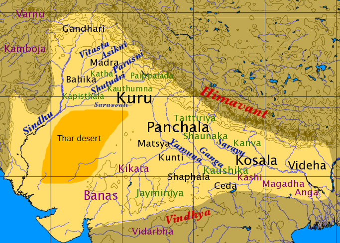
Map_of_Vedic_India.png (៦៨៣ × ៤៨៩ ភីកសែល ទំហំឯកសារ៖ ៤២៤គីឡូបៃ ប្រភេទ MIME៖ image/png)
Dbachmann, the copyright holder of this work, hereby publishes it under the following license:

|
រូបភាពនៃទំព័រនេះជាកម្មសិទ្ធិរបស់GNU Free Documentation License។ Version 1.2 ឬក៏ខ្ពស់ជាងនេះត្រូវបានឧបត្ថមគាំទ្រដោយ មូលនិធិសូហ្វវែរដោយឥតគិតថ្លៃ (Free Software Foundation) ដែលមិនមានផ្នែកណាមួយរបស់ប្រភពដើមរួមទាំងអក្សរនៅលើគំរបមុខនិងខ្នង ត្រូវបានផ្លាស់ប្តូរទេ។ ចំពោះផ្នែកដែលមិនអាចផ្លាស់ប្តូរបាន សូមមើលGNU Free Documentation License។ |
| ឯកសារនេះជាប់អាជ្ញាបណ្ឌCreative Commons Attribution-Share Alike 3.0 Unported។ | ||
| ភាពជាម្ចាស់កម្មសិទ្ធ: Dbachmann | ||
| ||
| This licensing tag was added to this file as part of the GFDL licensing update. |
derivative works
Derivative works of this file: Map of Vedic India ru.png
ប្រវត្តិឯកសារ
ចុចលើម៉ោងនិងកាលបរិច្ឆេទដើម្បីមើលឯកសារដែលបានផ្ទុកឡើងនៅពេលនោះ។
| ម៉ោងនិងកាលបរិច្ឆេទ | កូនរូបភាព | វិមាត្រ | អ្នកប្រើប្រាស់ | យោបល់ | |
|---|---|---|---|---|---|
| បច្ចុប្បន្ន | ម៉ោង១៣:៥៩ ថ្ងៃព្រហស្បតិ៍ ទី១៨ ខែកុម្ភៈ ឆ្នាំ២០១៦ | | ៦៨៣ × ៤៨៩ (៤២៤គីឡូបៃ) | Mywikicommons | Reverted to version as of 13:48, 18 February 2016 (UTC) |
| ម៉ោង១៣:៥៩ ថ្ងៃព្រហស្បតិ៍ ទី១៨ ខែកុម្ភៈ ឆ្នាំ២០១៦ |  | ៦៨៣ × ៤៨៩ (៤២៤គីឡូបៃ) | Mywikicommons | Reupload - Minor addition : Thar Desert (text) added to map according to already given sources. | |
| ម៉ោង១៣:៤៨ ថ្ងៃព្រហស្បតិ៍ ទី១៨ ខែកុម្ភៈ ឆ្នាំ២០១៦ |  | ៦៨៣ × ៤៨៩ (៤២៤គីឡូបៃ) | Mywikicommons | Minor addition : Thar Desert (text) added to map according to already given sources. | |
| ម៉ោង១១:០៤ ថ្ងៃច័ន្ទ ទី២២ ខែសីហា ឆ្នាំ២០០៥ |  | ៦៨៣ × ៤៨៩ (៣៥៣គីឡូបៃ) | Dbachmann | by en:User:Dbachmann {{GFDL}} |
បម្រើបម្រាស់ឯកសារ
ទំព័រ ខាងក្រោមប្រើប្រាស់ឯកសារនេះ ៖
បម្រើបម្រាស់ឯកសារជាសាកល
វីគីដទៃទៀតដូចខាងក្រោមនេះប្រើប្រាស់ឯកសារនេះ៖
- ការប្រើប្រាស់នៅក្នុង af.wikipedia.org
- ការប្រើប្រាស់នៅក្នុង als.wikipedia.org
- ការប្រើប្រាស់នៅក្នុង anp.wikipedia.org
- ការប្រើប្រាស់នៅក្នុង ar.wikipedia.org
- ការប្រើប្រាស់នៅក្នុង ast.wikipedia.org
- ការប្រើប្រាស់នៅក្នុង az.wikipedia.org
- ការប្រើប្រាស់នៅក្នុង bg.wikipedia.org
- ការប្រើប្រាស់នៅក្នុង bh.wikipedia.org
- ការប្រើប្រាស់នៅក្នុង bn.wikipedia.org
- ការប្រើប្រាស់នៅក្នុង ca.wikipedia.org
- ការប្រើប្រាស់នៅក្នុង cs.wikipedia.org
- ការប្រើប្រាស់នៅក្នុង de.wikipedia.org
- ការប្រើប្រាស់នៅក្នុង el.wikipedia.org
- ការប្រើប្រាស់នៅក្នុង en.wikipedia.org
View more global usage of this file.