
ឯកសារ:Pacaya erupting in 1976.jpg
ទំហំរបស់ការមើលមុននេះ: ៨០០ × ៥២២ ភីកសែ។ ភាពម៉ត់ផ្សេងទៀត៖ ៣២០ × ២០៩ ភីកសែ | ៦៤០ × ៤១៧ ភីកសែ | ៩៦៩ × ៦៣២ ភីកសែ។
រូបភាពដើម (៩៦៩ × ៦៣២ ភីកសែល ទំហំឯកសារ៖ ៦០គីឡូបៃ ប្រភេទ MIME៖ image/jpeg)
ចំណារពន្យល់
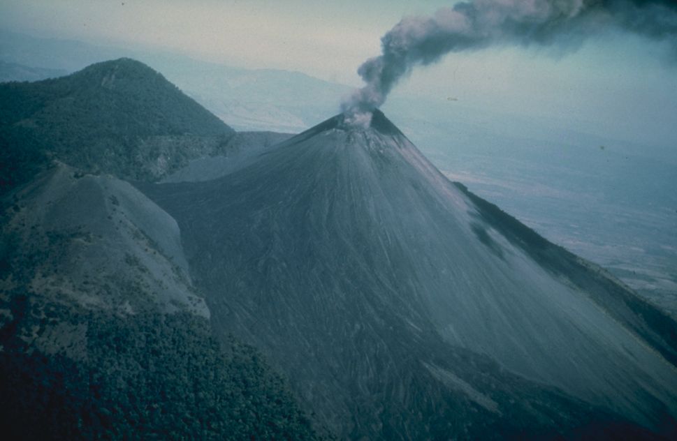
| ការពិពណ៌នា | Ashy eruption at Pacaya, shortly after a very large earthquake affected the area in 1976. Photo credit: USGS. . |
| កាលបរិច្ឆេទ | |
| ប្រភព | From [1] |
| អ្នកនិពន្ធ | USGS |
ការដាក់អាជ្ញាប័ណ្ណ
This image is in the public domain in the United States because it only contains materials that originally came from the United States Geological Survey, an agency of the United States Department of the Interior. For more information, see the official USGS copyright policy.
|
Original upload log
The original description page was here. All following user names refer to en.wikipedia.
- 2005-04-06 14:27 Worldtraveller 969×632×8 (61084 bytes) Ashy eruption at Pacaya, shortly after a very large earthquake affected the area in 1976. Photo credit: USGS. From [http://www.ngdc.noaa.gov/seg/hazard/slideset/28/28_576_slide.shtml]. {{PD-USGov-Interior-USGS}}
ប្រវត្តិឯកសារ
ចុចលើម៉ោងនិងកាលបរិច្ឆេទដើម្បីមើលឯកសារដែលបានផ្ទុកឡើងនៅពេលនោះ។
| ម៉ោងនិងកាលបរិច្ឆេទ | កូនរូបភាព | វិមាត្រ | អ្នកប្រើប្រាស់ | យោបល់ | |
|---|---|---|---|---|---|
| បច្ចុប្បន្ន | ម៉ោង២៣:៣៦ ថ្ងៃសៅរ៍ ទី១៩ ខែឧសភា ឆ្នាំ២០០៧ | | ៩៦៩ × ៦៣២ (៦០គីឡូបៃ) | Yonidebest | {{Information |Description=Ashy eruption at Pacaya, shortly after a very large earthquake affected the area in 1976. Photo credit: USGS. From [http://www.ngdc.noaa.gov/seg/hazard/slideset/28/28_576_slide.shtml]. |Source=Originally from [http://en.wikipe |
បម្រើបម្រាស់ឯកសារ
ទំព័រ ខាងក្រោមប្រើប្រាស់ឯកសារនេះ ៖
បម្រើបម្រាស់ឯកសារជាសាកល
វីគីដទៃទៀតដូចខាងក្រោមនេះប្រើប្រាស់ឯកសារនេះ៖
- ការប្រើប្រាស់នៅក្នុង ar.wikipedia.org
- ការប្រើប្រាស់នៅក្នុង arz.wikipedia.org
- ការប្រើប្រាស់នៅក្នុង az.wikipedia.org
- ការប្រើប្រាស់នៅក្នុង ca.wikipedia.org
- ការប្រើប្រាស់នៅក្នុង ceb.wikipedia.org
- ការប្រើប្រាស់នៅក្នុង cs.wikipedia.org
- ការប្រើប្រាស់នៅក្នុង de.wikipedia.org
- ការប្រើប្រាស់នៅក្នុង de.wikinews.org
- ការប្រើប្រាស់នៅក្នុង el.wikipedia.org
- ការប្រើប្រាស់នៅក្នុង en.wikipedia.org
- ការប្រើប្រាស់នៅក្នុង en.wikinews.org
- ការប្រើប្រាស់នៅក្នុង en.wikivoyage.org
- ការប្រើប្រាស់នៅក្នុង es.wikipedia.org
- ការប្រើប្រាស់នៅក្នុង es.wikivoyage.org
- ការប្រើប្រាស់នៅក្នុង fa.wikipedia.org
- ការប្រើប្រាស់នៅក្នុង fi.wikipedia.org
- ការប្រើប្រាស់នៅក្នុង fr.wikipedia.org
- ការប្រើប្រាស់នៅក្នុង he.wikipedia.org
- ការប្រើប្រាស់នៅក្នុង he.wikivoyage.org
- ការប្រើប្រាស់នៅក្នុង hu.wikipedia.org
- ការប្រើប្រាស់នៅក្នុង hy.wikipedia.org
- ការប្រើប្រាស់នៅក្នុង id.wikipedia.org
- ការប្រើប្រាស់នៅក្នុង it.wikipedia.org
- ការប្រើប្រាស់នៅក្នុង it.wikivoyage.org
- ការប្រើប្រាស់នៅក្នុង ko.wikipedia.org
- ការប្រើប្រាស់នៅក្នុង li.wikipedia.org
- ការប្រើប្រាស់នៅក្នុង lld.wikipedia.org
- ការប្រើប្រាស់នៅក្នុង lt.wikipedia.org
- ការប្រើប្រាស់នៅក្នុង ms.wikipedia.org
- ការប្រើប្រាស់នៅក្នុង nl.wikipedia.org
- ការប្រើប្រាស់នៅក្នុង nn.wikipedia.org
- ការប្រើប្រាស់នៅក្នុង no.wikipedia.org
- ការប្រើប្រាស់នៅក្នុង pl.wikipedia.org
View more global usage of this file.