
ឯកសារ:PanAmericanHwy.png

ទំហំរបស់ការមើលមុននេះ: ៤៣៤ × ៥៩៩ ភីកសែ។ ភាពម៉ត់ផ្សេងទៀត៖ ១៧៤ × ២៤០ ភីកសែ | ៣៤៨ × ៤៨០ ភីកសែ | ៥៥៦ × ៧៦៨ ភីកសែ | ៧៤២ × ១០២៤ ភីកសែ | ១៦០០ × ២២០៨ ភីកសែ។
រូបភាពដើម (១៦០០ × ២២០៨ ភីកសែល ទំហំឯកសារ៖ ២.០៨មេកាបៃ ប្រភេទ MIME៖ image/png)

|
រូបភាព road mapនេះ គួរតែបង្កើតឡើងវិញដោយប្រើក្រាភិកវ៉ិចទ័រ ដែលជាប្រភេទហ្វាល់ SVG ។ ការបង្កើតរូបភាពជាហ្វាល់ SVG ផ្តល់នូវអត្ថប្រយោជន៍ជាច្រើន។ ចំពោះព័ត៌មានបន្ថែម សូមមើល Commons:Media for cleanup ។ ប្រសិនបើទំរង់ SVG នៃរូបភាពនេះត្រូវបានបង្កើតរួចរាល់ហើយ សូមអាប់ឡូដវា។ បន្ទាប់ពីអាប់ឡូដជាទំរង់ SVG សូមជំនួសទំព័រគំរូនេះដោយ {{vector version available|ឈ្មោះរូបភាពថ្មី.svg}} ។
|
ចំណារពន្យល់
| ការពិពណ៌នា |
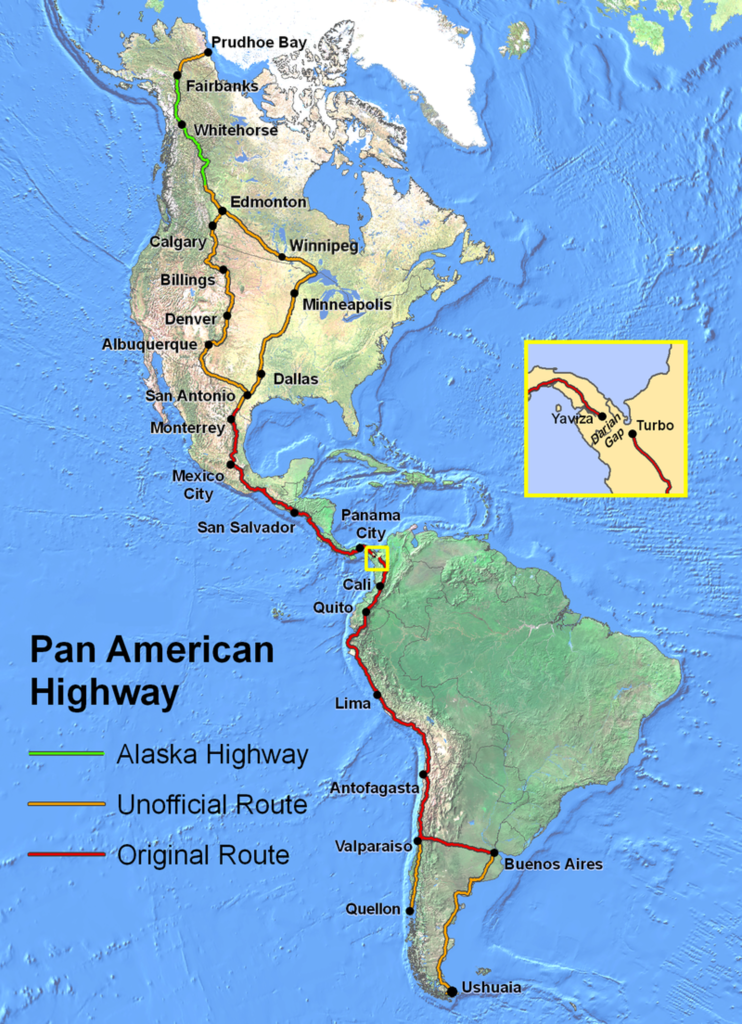
English: Route of the Pan-American Highway. Includes original route and unofficial extensions but doesn't reflect official designation of U.S. interstate highway system. Hotine Oblique Mercator Two Point Natural Origin Projection. |
| ប្រភព | ការងារផ្ទាល់របស់អ្នកផ្ទុកឡើង |
| អ្នកនិពន្ធ | Created by en:User:Seaweege and released to PD |
ការដាក់អាជ្ញាប័ណ្ណ

|
The copyright holder of this work allows anyone to use it for any purpose including unrestricted redistribution, commercial use, and modification.
Usage notes:
|
ប្រវត្តិឯកសារ
ចុចលើម៉ោងនិងកាលបរិច្ឆេទដើម្បីមើលឯកសារដែលបានផ្ទុកឡើងនៅពេលនោះ។
| ម៉ោងនិងកាលបរិច្ឆេទ | កូនរូបភាព | វិមាត្រ | អ្នកប្រើប្រាស់ | យោបល់ | |
|---|---|---|---|---|---|
| បច្ចុប្បន្ន | ម៉ោង០២:៣២ ថ្ងៃអង្គារ ទី១៨ ខែមករា ឆ្នាំ២០២២ | | ១៦០០ × ២២០៨ (២.០៨មេកាបៃ) | Natewich | Route of the Pan American Highway. Includes original route and unofficial extensions. Hotine Oblique Mercator Two Point Natural Origin Projection. Taken from en:Image:PanAmericanHwy.png. |
| ម៉ោង០១:៣៣ ថ្ងៃអង្គារ ទី២៧ ខែវិច្ឆិកា ឆ្នាំ២០០៧ |  | ១៣២៥ × ១៨២៨ (៣.៧២មេកាបៃ) | Jabul | Route of the Pan American Highway. Includes original route and unofficial extensions. Hotine Oblique Mercator Two Point Natural Origin Projection. Taken from en:Image:PanAmericanHwy.png. | |
| ម៉ោង០១:១៨ ថ្ងៃអង្គារ ទី២៧ ខែវិច្ឆិកា ឆ្នាំ២០០៧ |  | ១៣២៥ × ១៨២៨ (៣.៧២មេកាបៃ) | Jabul | ||
| ម៉ោង០២:៣៦ ថ្ងៃអាទិត្យ ទី១៧ ខែមិថុនា ឆ្នាំ២០០៧ |  | ១៣២៥ × ១៨២៨ (៣.៦មេកាបៃ) | SchuminWeb | {{Information |Description=Route of the Pan American Highway. Includes original route and unofficial extensions. Hotine Oblique Mercator Two Point Natural Origin Projection |Source=Originally from [http://en.wikipedia.org en.wikipedia]; description page | |
| ម៉ោង១៥:២៦ ថ្ងៃសុក្រ ទី២៩ ខែធ្នូ ឆ្នាំ២០០៦ |  | ១៧០០ × ២២០០ (៣.៦២មេកាបៃ) | Chigliak | Original Description: Route of the Pan American Highway. Includes original route and unofficial extensions. Hotine Oblique Mercator Two Point Natural Origin Projection. Taken from en:Image:PanAmericanHwy.png. Created by en:User:Seaweege and rea |
បម្រើបម្រាស់ឯកសារ
ទំព័រ ខាងក្រោមប្រើប្រាស់ឯកសារនេះ ៖
បម្រើបម្រាស់ឯកសារជាសាកល
វីគីដទៃទៀតដូចខាងក្រោមនេះប្រើប្រាស់ឯកសារនេះ៖
- ការប្រើប្រាស់នៅក្នុង ar.wikipedia.org
- ការប្រើប្រាស់នៅក្នុង be-tarask.wikipedia.org
- ការប្រើប្រាស់នៅក្នុង be.wikipedia.org
- ការប្រើប្រាស់នៅក្នុង bg.wikipedia.org
- ការប្រើប្រាស់នៅក្នុង bn.wikipedia.org
- ការប្រើប្រាស់នៅក្នុង cs.wikipedia.org
- ការប្រើប្រាស់នៅក្នុង de.wikipedia.org
- ការប្រើប្រាស់នៅក្នុង de.wikivoyage.org
- ការប្រើប្រាស់នៅក្នុង el.wikipedia.org
- ការប្រើប្រាស់នៅក្នុង en.wikipedia.org
- ការប្រើប្រាស់នៅក្នុង en.wikivoyage.org
- ការប្រើប្រាស់នៅក្នុង eo.wikipedia.org
- ការប្រើប្រាស់នៅក្នុង et.wikipedia.org
- ការប្រើប្រាស់នៅក្នុង eu.wikipedia.org
- ការប្រើប្រាស់នៅក្នុង fa.wikipedia.org
- ការប្រើប្រាស់នៅក្នុង fi.wikipedia.org
- ការប្រើប្រាស់នៅក្នុង fr.wikipedia.org
- ការប្រើប្រាស់នៅក្នុង he.wikipedia.org
- ការប្រើប្រាស់នៅក្នុង hi.wikibooks.org
- ការប្រើប្រាស់នៅក្នុង id.wikipedia.org
- ការប្រើប្រាស់នៅក្នុង it.wikipedia.org
- ការប្រើប្រាស់នៅក្នុង ja.wikipedia.org
- ការប្រើប្រាស់នៅក្នុង ka.wikipedia.org
- ការប្រើប្រាស់នៅក្នុង ko.wikipedia.org
- ការប្រើប្រាស់នៅក្នុង lt.wikipedia.org
- ការប្រើប្រាស់នៅក្នុង ml.wikipedia.org
- ការប្រើប្រាស់នៅក្នុង mr.wikipedia.org
- ការប្រើប្រាស់នៅក្នុង ms.wikipedia.org
- ការប្រើប្រាស់នៅក្នុង nl.wikipedia.org
- ការប្រើប្រាស់នៅក្នុង no.wikipedia.org
View more global usage of this file.