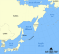
ឯកសារ:Sea of Okhotsk map with state labels.png

ទំហំរបស់ការមើលមុននេះ: ៦៥៧ × ៥៩៩ ភីកសែ។ ភាពម៉ត់ផ្សេងទៀត៖ ២៦៣ × ២៤០ ភីកសែ | ៥២៦ × ៤៨០ ភីកសែ | ៩៩០ × ៩០៣ ភីកសែ។
រូបភាពដើម (៩៩០ × ៩០៣ ភីកសែល ទំហំឯកសារ៖ ៨៤គីឡូបៃ ប្រភេទ MIME៖ image/png)
ប្រវត្តិឯកសារ
ចុចលើម៉ោងនិងកាលបរិច្ឆេទដើម្បីមើលឯកសារដែលបានផ្ទុកឡើងនៅពេលនោះ។
| ម៉ោងនិងកាលបរិច្ឆេទ | កូនរូបភាព | វិមាត្រ | អ្នកប្រើប្រាស់ | យោបល់ | |
|---|---|---|---|---|---|
| បច្ចុប្បន្ន | ម៉ោង១៧:១៣ ថ្ងៃសុក្រ ទី២៣ ខែមេសា ឆ្នាំ២០១០ |  | ៩៩០ × ៩០៣ (៨៤គីឡូបៃ) | Ras67 | cropped |
| ម៉ោង១០:៥៨ ថ្ងៃសៅរ៍ ទី០៤ ខែសីហា ឆ្នាំ២០០៧ |  | ១០០០ × ៩១៣ (៨៥គីឡូបៃ) | Nihad Hamzic | Greatly reduced file size by removing the alpha channel, what enabled me to losslessly reduce the color domain do 8-bit. If alpha channel is indeed needed, then revert this image. | |
| ម៉ោង១៥:៤០ ថ្ងៃច័ន្ទ ទី២៤ ខែតុលា ឆ្នាំ២០០៥ |  | ១០០០ × ៩១៣ (៤០៨គីឡូបៃ) | NormanEinstein | This is a map showing the location of the Sea of Okhotsk. The sea is bordered by Russia and Japan. Created by NormanEinstein, October 24, 2005. {{GFDL-self}} Category:Maps of seas |
បម្រើបម្រាស់ឯកសារ
ទំព័រ ខាងក្រោមប្រើប្រាស់ឯកសារនេះ ៖
បម្រើបម្រាស់ឯកសារជាសាកល
វីគីដទៃទៀតដូចខាងក្រោមនេះប្រើប្រាស់ឯកសារនេះ៖
- ការប្រើប្រាស់នៅក្នុង ace.wikipedia.org
- ការប្រើប្រាស់នៅក្នុង af.wikipedia.org
- ការប្រើប្រាស់នៅក្នុង ar.wikipedia.org
- ការប្រើប្រាស់នៅក្នុង ast.wikipedia.org
- ការប្រើប្រាស់នៅក្នុង avk.wikipedia.org
- ការប្រើប្រាស់នៅក្នុង azb.wikipedia.org
- ការប្រើប្រាស់នៅក្នុង az.wikipedia.org
- ការប្រើប្រាស់នៅក្នុង az.wiktionary.org
- ការប្រើប្រាស់នៅក្នុង bat-smg.wikipedia.org
- ការប្រើប្រាស់នៅក្នុង be-tarask.wikipedia.org
- ការប្រើប្រាស់នៅក្នុង be.wikipedia.org
- ការប្រើប្រាស់នៅក្នុង bg.wikipedia.org
- ការប្រើប្រាស់នៅក្នុង bn.wikipedia.org
- ការប្រើប្រាស់នៅក្នុង br.wikipedia.org
- ការប្រើប្រាស់នៅក្នុង bxr.wikipedia.org
- ការប្រើប្រាស់នៅក្នុង ca.wikipedia.org
- ការប្រើប្រាស់នៅក្នុង ca.wikinews.org
- ការប្រើប្រាស់នៅក្នុង ckb.wikipedia.org
- ការប្រើប្រាស់នៅក្នុង cs.wikipedia.org
- ការប្រើប្រាស់នៅក្នុង cy.wikipedia.org
- ការប្រើប្រាស់នៅក្នុង da.wikipedia.org
- ការប្រើប្រាស់នៅក្នុង de.wikipedia.org
- ការប្រើប្រាស់នៅក្នុង dsb.wikipedia.org
- ការប្រើប្រាស់នៅក្នុង el.wikipedia.org
- ការប្រើប្រាស់នៅក្នុង en.wikipedia.org
- ការប្រើប្រាស់នៅក្នុង en.wikinews.org
View more global usage of this file.


