
ឯកសារ:Thủy điện Ialy (Dam).jpg

ទំហំរបស់ការមើលមុននេះ: ៨០០ × ៥៣៣ ភីកសែ។ ភាពម៉ត់ផ្សេងទៀត៖ ៣២០ × ២១៣ ភីកសែ | ៦៤០ × ៤២៧ ភីកសែ | ១០២៤ × ៦៨៣ ភីកសែ | ១២៨០ × ៨៥៣ ភីកសែ | ១៩២០ × ១២៨០ ភីកសែ។
រូបភាពដើម (១៩២០ × ១២៨០ ភីកសែល ទំហំឯកសារ៖ ១.៥១មេកាបៃ ប្រភេទ MIME៖ image/jpeg)
.jpg)
ចំណារពន្យល់
| ការពិពណ៌នា |
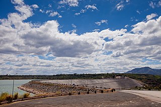
Русский: Гравитационная плотина электростанции Ияли в провинции Зялай, Вьетнам English: Yali Falls Dam in Gia Lai and Kon Tum provinces, Vietnam Tiếng Việt: Công ty Thủy điện Ialy |
| កាលបរិច្ឆេទ | |
| ប្រភព | ការងារផ្ទាល់របស់អ្នកផ្ទុកឡើង |
| អ្នកនិពន្ធ | [Tycho] talk , http://shansov.net |
| ទីតាំងម៉ាស៊ីនថត | | រូបភាពនេះនិងរូបភាពផ្សេងទៀតនៅឯទីតាំងរបស់វាលើ: OpenStreetMap |
|---|
.jpg¶ms=014.237617_N_0107.830945_E_globe:Earth_type:camera_heading:180.00&language=km)
| Object location | | រូបភាពនេះនិងរូបភាពផ្សេងទៀតនៅឯទីតាំងរបស់វាលើ: OpenStreetMap |
|---|
.jpg¶ms=014.231689_N_0107.831841_E_globe:Earth_class:object_type:landmark_&language=km)
ការដាក់អាជ្ញាប័ណ្ណ
I, the copyright holder of this work, hereby publish it under the following license:
ឯកសារនេះជាប់អាជ្ញាបណ្ឌCreative Commons Attribution-Share Alike 3.0 Unported។
- អ្នកមានសិទ្ធិ៖
- ចែកចាយ – ថតចំលងនិងចែកចាយស្នាដៃនេះ
- កែច្នៃ – កែច្នៃយកទៅប្រើ
- ក្រោមលក្ខខណ្ឌដូចតទៅនេះ៖
- ភាពជាម្ចាស់កម្មសិទ្ធ – You must give appropriate credit, provide a link to the license, and indicate if changes were made. You may do so in any reasonable manner, but not in any way that suggests the licensor endorses you or your use.
- share alike – If you remix, transform, or build upon the material, you must distribute your contributions under the same or compatible license as the original.
ប្រវត្តិឯកសារ
ចុចលើម៉ោងនិងកាលបរិច្ឆេទដើម្បីមើលឯកសារដែលបានផ្ទុកឡើងនៅពេលនោះ។
| ម៉ោងនិងកាលបរិច្ឆេទ | កូនរូបភាព | វិមាត្រ | អ្នកប្រើប្រាស់ | យោបល់ | |
|---|---|---|---|---|---|
| បច្ចុប្បន្ន | ម៉ោង១៤:១៤ ថ្ងៃច័ន្ទ ទី២៣ ខែកុម្ភៈ ឆ្នាំ២០១៥ | | ១៩២០ × ១២៨០ (១.៥១មេកាបៃ) | Shansov.net | User created page with UploadWizard |
បម្រើបម្រាស់ឯកសារ
ទំព័រ ខាងក្រោមប្រើប្រាស់ឯកសារនេះ ៖
បម្រើបម្រាស់ឯកសារជាសាកល
វីគីដទៃទៀតដូចខាងក្រោមនេះប្រើប្រាស់ឯកសារនេះ៖
- ការប្រើប្រាស់នៅក្នុង ceb.wikipedia.org
- ការប្រើប្រាស់នៅក្នុង en.wikipedia.org
- ការប្រើប្រាស់នៅក្នុង fa.wikipedia.org
- ការប្រើប្រាស់នៅក្នុង fr.wikipedia.org
- ការប្រើប្រាស់នៅក្នុង ko.wikipedia.org
- ការប្រើប្រាស់នៅក្នុង no.wikipedia.org
- ការប្រើប្រាស់នៅក្នុង ru.wikipedia.org
- ការប្រើប្រាស់នៅក្នុង uk.wikipedia.org
- ការប្រើប្រាស់នៅក្នុង vi.wikipedia.org
- ការប្រើប្រាស់នៅក្នុង www.wikidata.org
.jpg)