
ឯកសារ:环太平洋地区.svg

Size of this PNG preview of this SVG file: ៨០០ × ៤០៦ ភីកសែ. ភាពម៉ត់ផ្សេងទៀត៖ ៣២០ × ១៦២ ភីកសែ | ៦៤០ × ៣២៥ ភីកសែ | ១០២៤ × ៥២០ ភីកសែ | ១២៨០ × ៦៥០ ភីកសែ | ២៥៦០ × ១២៩៩ ភីកសែ | ៩៤០ × ៤៧៧ ភីកសែ។
រូបភាពដើម (ឯកសារប្រភេទSVG ៩៤០ × ៤៧៧ ភីកសែល ទំហំឯកសារ៖ ១.៤៩មេកាបៃ)
ចំណារពន្យល់
| ការពិពណ៌នា |
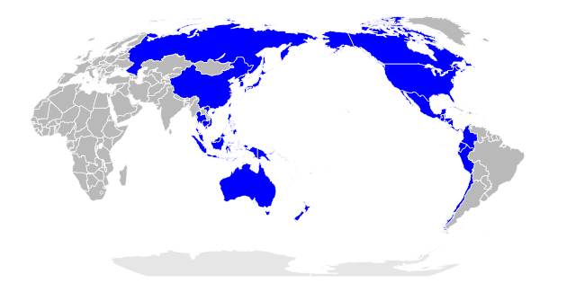
中文:环太平洋地区,亦称亚太区。此图以太平洋为中心,直观显示大洋两岸地理 English: Pacific Rim region, also known as the Asia-Pacific. This map places the Pacific Ocean in the center, intuitively showing the geography of both sides of the Pacific. |
| កាលបរិច្ឆេទ | |
| ប្រភព | BlankMap-World-162E.svg |
| អ្នកនិពន្ធ | 玖巧仔 |
| ទំរង់ផ្សេងទៀត |
 |
ការដាក់អាជ្ញាប័ណ្ណ
I, the copyright holder of this work, hereby publish it under the following licenses:
ឯកសារនេះជាប់អាជ្ញាបណ្ឌCreative Commons Attribution-Share Alike 3.0 Unported។
- អ្នកមានសិទ្ធិ៖
- ចែកចាយ – ថតចំលងនិងចែកចាយស្នាដៃនេះ
- កែច្នៃ – កែច្នៃយកទៅប្រើ
- ក្រោមលក្ខខណ្ឌដូចតទៅនេះ៖
- ភាពជាម្ចាស់កម្មសិទ្ធ – You must give appropriate credit, provide a link to the license, and indicate if changes were made. You may do so in any reasonable manner, but not in any way that suggests the licensor endorses you or your use.
- share alike – If you remix, transform, or build upon the material, you must distribute your contributions under the same or compatible license as the original.

|
រូបភាពនៃទំព័រនេះជាកម្មសិទ្ធិរបស់GNU Free Documentation License។ Version 1.2 ឬក៏ខ្ពស់ជាងនេះត្រូវបានឧបត្ថមគាំទ្រដោយ មូលនិធិសូហ្វវែរដោយឥតគិតថ្លៃ (Free Software Foundation) ដែលមិនមានផ្នែកណាមួយរបស់ប្រភពដើមរួមទាំងអក្សរនៅលើគំរបមុខនិងខ្នង ត្រូវបានផ្លាស់ប្តូរទេ។ ចំពោះផ្នែកដែលមិនអាចផ្លាស់ប្តូរបាន សូមមើលGNU Free Documentation License។ |
You may select the license of your choice.
ប្រវត្តិឯកសារ
ចុចលើម៉ោងនិងកាលបរិច្ឆេទដើម្បីមើលឯកសារដែលបានផ្ទុកឡើងនៅពេលនោះ។
| ម៉ោងនិងកាលបរិច្ឆេទ | កូនរូបភាព | វិមាត្រ | អ្នកប្រើប្រាស់ | យោបល់ | |
|---|---|---|---|---|---|
| បច្ចុប្បន្ន | ម៉ោង០១:៤០ ថ្ងៃសៅរ៍ ទី០២ ខែកក្កដា ឆ្នាំ២០១១ | | ៩៤០ × ៤៧៧ (១.៤៩មេកាបៃ) | 玖巧仔 | {{Information |Description ={{zh|1=环太平洋地区,亦称亚太区。此图以太平洋为中心,直观显示大洋两岸地理}} |Source =BlankMap-World-162E.svg |Author =玖巧仔 |Date =2011年 |Pe |
បម្រើបម្រាស់ឯកសារ
ទំព័រ ខាងក្រោមប្រើប្រាស់ឯកសារនេះ ៖
បម្រើបម្រាស់ឯកសារជាសាកល
វីគីដទៃទៀតដូចខាងក្រោមនេះប្រើប្រាស់ឯកសារនេះ៖
- ការប្រើប្រាស់នៅក្នុង bg.wikipedia.org
- ការប្រើប្រាស់នៅក្នុង bn.wikipedia.org
- ការប្រើប្រាស់នៅក្នុង ca.wikipedia.org
- ការប្រើប្រាស់នៅក្នុង cs.wikipedia.org
- ការប្រើប្រាស់នៅក្នុង de.wikipedia.org
- ការប្រើប្រាស់នៅក្នុង en.wikipedia.org
- ការប្រើប្រាស់នៅក្នុង eo.wikipedia.org
- ការប្រើប្រាស់នៅក្នុង hi.wikipedia.org
- ការប្រើប្រាស់នៅក្នុង hr.wikipedia.org
- ការប្រើប្រាស់នៅក្នុង kn.wikipedia.org
- ការប្រើប្រាស់នៅក្នុង ml.wikipedia.org
- ការប្រើប្រាស់នៅក្នុង my.wikipedia.org
- ការប្រើប្រាស់នៅក្នុង ne.wikipedia.org
- ការប្រើប្រាស់នៅក្នុង pl.wikipedia.org
- ការប្រើប្រាស់នៅក្នុង ru.wikipedia.org
- ការប្រើប្រាស់នៅក្នុង sk.wikipedia.org
- ការប្រើប្រាស់នៅក្នុង ta.wikipedia.org
- ការប្រើប្រាស់នៅក្នុង te.wikipedia.org
- ការប្រើប្រាស់នៅក្នុង th.wikipedia.org
- ការប្រើប្រាស់នៅក្នុង uk.wikipedia.org
- ការប្រើប្រាស់នៅក្នុង vi.wikipedia.org
- ការប្រើប្រាស់នៅក្នុង zh.wikipedia.org