
ឯកសារ:Andorra topographic map-en.svg

Size of this PNG preview of this SVG file: ៧៥០ × ៦០០ ភីកសែ. ភាពម៉ត់ផ្សេងទៀត៖ ៣០០ × ២៤០ ភីកសែ | ៦០០ × ៤៨០ ភីកសែ | ៩៦០ × ៧៦៨ ភីកសែ | ១២៨០ × ១០២៤ ភីកសែ | ២៥៦០ × ២០៤៨ ភីកសែ | ១៦២៥ × ១៣០០ ភីកសែ។
រូបភាពដើម (ឯកសារប្រភេទSVG ១៦២៥ × ១៣០០ ភីកសែល ទំហំឯកសារ៖ ១.៥៦មេកាបៃ)
ចំណារពន្យល់
| ការពិពណ៌នា |
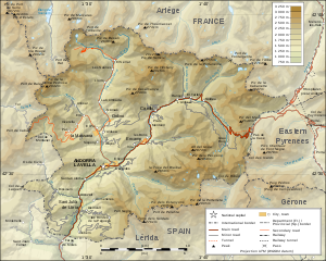
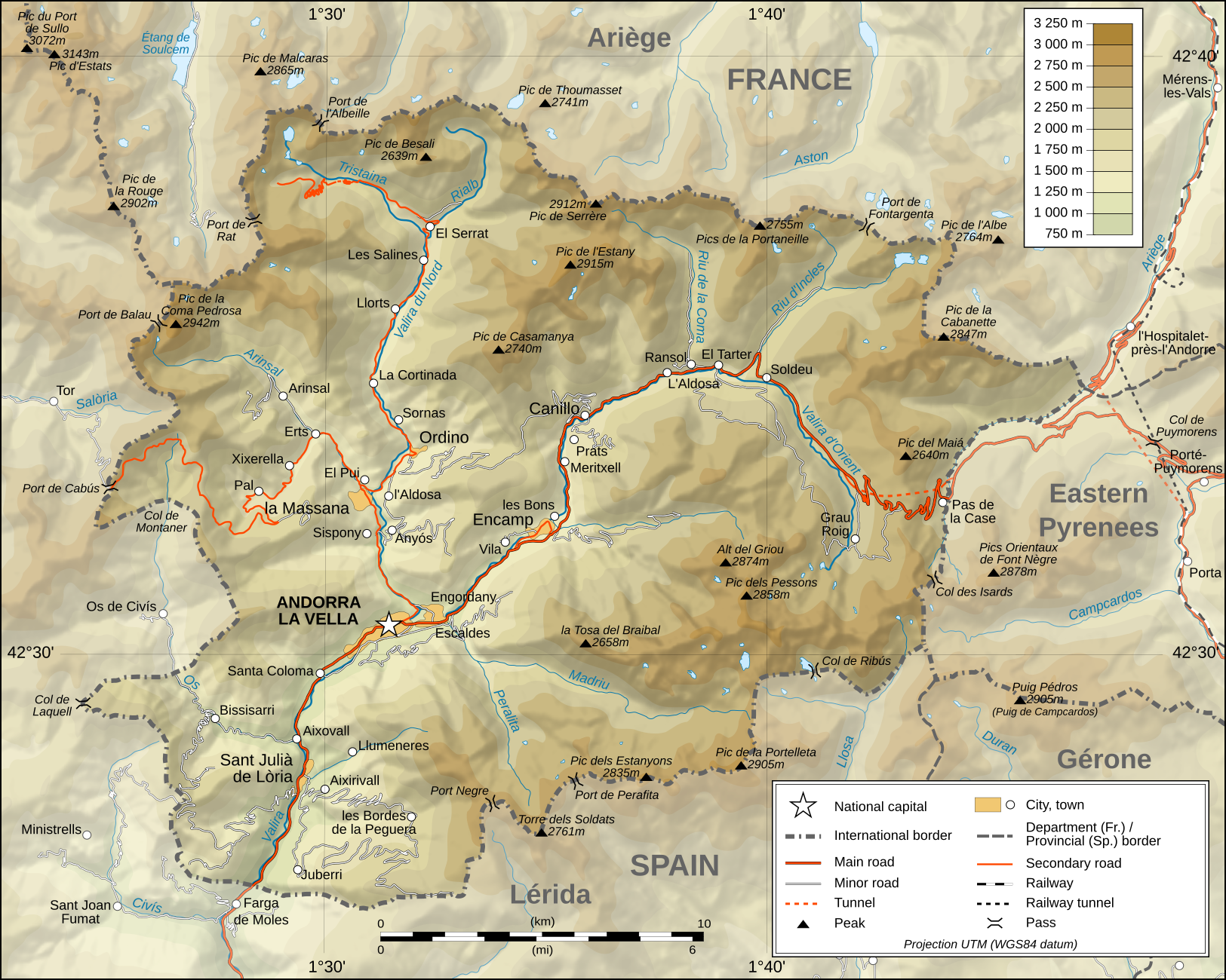
Deutsch: Topographische Karte von Andorra, englische Version English: Topographic map of Andorra Français : Carte topographique en anglais de l'Andorre |
| កាលបរិច្ឆេទ | February 2008 (translation March 2009) |
| ប្រភព |
English: Own work ; Topographic data from the NASA Shuttle Radar Topography Mission (SRTM3 v.2) (public domain) edited with 3DEM and dlgv32 Pro and vectorized with Inkscape ; UTM projection ; WGS84 datum ; shaded relief (composite image of N-W, W and N lightning positions) ; Reference used for the additional data : * Topographic maps available on the site of the Ministeri d'Urbanisme i Ordenament Territorial of Andorra ; * Géoportail France ; Approximate scale of topographic data : 1:400,000 (accuracy : about 100 m) ; Note : The shaded relief is a raster image embedded in the SVG file. Français : Création personnelle ; Données topographiques de la NASA Shuttle Radar Topography Mission (SRTM3 v.2) (domaine public) éditées avec 3DEM et dlgv32 Pro et vectorisées avec Inkscape ; projection UTM ; WGS84 datum ; relief ombré (image composite d'éclairages du N-O, O et N) ; Références utilisées pour les données complémentaires : * Cartes topographiques disponibles sur le site du Ministeri d'Urbanisme i Ordenament Territorial d'Andorre ; * Géoportail France ; Échelle approximative des données topographiques : 1:400 000 (précision : environ 100 m) ; Note : Le relief ombré est une image bitmap embarquée dans le fichier SVG. Approximate geographic limits of the map (3" close) : * SW corner : 42°24'30"N – 01°22'40"E * SE corner : 42°24'30"N – 01°50'20"E * NE corner : 42°40'55"N – 01°50'25"E * NW corner : 42°40'55"N – 01°22'35"E |
| អ្នកនិពន្ធ | Eric Gaba (Sting - fr:Sting), English translation: User:Goldsztajn |
| ការអនុញ្ញាត (ប្រើឯកសារនេះឡើងវិញ) |
GFDL / Attribution and Share-Alike required |
| ទំរង់ផ្សេងទៀត |
[]
|


|
ហ្វាល់ SVG នេះបង្កប់ឃ្លាជាអក្សរដែលអាចឲ្យអ្នកងាយស្រួលបកប្រែជាភាសារបស់អ្នក។ ព័ត៌មានលំអិត (ជាភាសាអង់គ្លេស) ចំពោះរូបភាព SVG អ្នកអាចប្រើ[toolforge:svgtranslate/File:Andorra_topographic_map-en.svglink ទំព័រនេះ] ដើម្បីបកប្រែវាជាភាសារបស់អ្នក។ |
ការដាក់អាជ្ញាប័ណ្ណ
I, the copyright holder of this work, hereby publish it under the following licenses:

|
រូបភាពនៃទំព័រនេះជាកម្មសិទ្ធិរបស់GNU Free Documentation License។ Version 1.2 ឬក៏ខ្ពស់ជាងនេះត្រូវបានឧបត្ថមគាំទ្រដោយ មូលនិធិសូហ្វវែរដោយឥតគិតថ្លៃ (Free Software Foundation) ដែលមិនមានផ្នែកណាមួយរបស់ប្រភពដើមរួមទាំងអក្សរនៅលើគំរបមុខនិងខ្នង ត្រូវបានផ្លាស់ប្តូរទេ។ ចំពោះផ្នែកដែលមិនអាចផ្លាស់ប្តូរបាន សូមមើលGNU Free Documentation License។ |
ឯកសារនេះជាប់អាជ្ញាបណ្ឌCreative Commons Attribution-Share Alike 3.0 Unported។
- អ្នកមានសិទ្ធិ៖
- ចែកចាយ – ថតចំលងនិងចែកចាយស្នាដៃនេះ
- កែច្នៃ – កែច្នៃយកទៅប្រើ
- ក្រោមលក្ខខណ្ឌដូចតទៅនេះ៖
- ភាពជាម្ចាស់កម្មសិទ្ធ – You must give appropriate credit, provide a link to the license, and indicate if changes were made. You may do so in any reasonable manner, but not in any way that suggests the licensor endorses you or your use.
- share alike – If you remix, transform, or build upon the material, you must distribute your contributions under the same or compatible license as the original.
You may select the license of your choice.
ប្រវត្តិឯកសារ
ចុចលើម៉ោងនិងកាលបរិច្ឆេទដើម្បីមើលឯកសារដែលបានផ្ទុកឡើងនៅពេលនោះ។
| ម៉ោងនិងកាលបរិច្ឆេទ | កូនរូបភាព | វិមាត្រ | អ្នកប្រើប្រាស់ | យោបល់ | |
|---|---|---|---|---|---|
| បច្ចុប្បន្ន | ម៉ោង០១:៣៤ ថ្ងៃច័ន្ទ ទី៣០ ខែមីនា ឆ្នាំ២០០៩ | | ១៦២៥ × ១៣០០ (១.៥៦មេកាបៃ) | Goldsztajn | {{Information |Description={{en|1=Map of Andorra}} |Source=http://commons.wikimedia.org/wiki/File:Andorra_topographic_map-fr.svg |Author=User:Sting fr:Utilisateur:Sting, english translation |Date=2009-03-30 |Permission= |other_versions= }} <!--{{ |
បម្រើបម្រាស់ឯកសារ
គ្មានទំព័រណាមួយដែលប្រើប្រាស់ឯកសារនេះទេ។
បម្រើបម្រាស់ឯកសារជាសាកល
វីគីដទៃទៀតដូចខាងក្រោមនេះប្រើប្រាស់ឯកសារនេះ៖
- ការប្រើប្រាស់នៅក្នុង af.wikipedia.org
- ការប្រើប្រាស់នៅក្នុង ar.wikipedia.org
- ការប្រើប្រាស់នៅក្នុង azb.wikipedia.org
- ការប្រើប្រាស់នៅក្នុង bn.wikipedia.org
- ការប្រើប្រាស់នៅក្នុង el.wikipedia.org
- ការប្រើប្រាស់នៅក្នុង en.wikipedia.org
- ការប្រើប្រាស់នៅក្នុង fa.wikipedia.org
- ការប្រើប្រាស់នៅក្នុង fi.wikipedia.org
- ការប្រើប្រាស់នៅក្នុង ga.wikipedia.org
- ការប្រើប្រាស់នៅក្នុង gl.wikipedia.org
- ការប្រើប្រាស់នៅក្នុង hr.wiktionary.org
- ការប្រើប្រាស់នៅក្នុង id.wikipedia.org
- ការប្រើប្រាស់នៅក្នុង is.wikipedia.org
- ការប្រើប្រាស់នៅក្នុង ka.wikipedia.org
- ការប្រើប្រាស់នៅក្នុង lt.wikipedia.org
- ការប្រើប្រាស់នៅក្នុង ms.wikipedia.org
- ការប្រើប្រាស់នៅក្នុង pnb.wikipedia.org
- ការប្រើប្រាស់នៅក្នុង ro.wikipedia.org
- ការប្រើប្រាស់នៅក្នុង ru.wikipedia.org
- ការប្រើប្រាស់នៅក្នុង sv.wikipedia.org
- ការប្រើប្រាស់នៅក្នុង te.wikipedia.org
- ការប្រើប្រាស់នៅក្នុង trv.wikipedia.org
- ការប្រើប្រាស់នៅក្នុង uk.wikipedia.org
- ការប្រើប្រាស់នៅក្នុង vep.wikipedia.org
- ការប្រើប្រាស់នៅក្នុង vi.wikipedia.org
- ការប្រើប្រាស់នៅក្នុង www.wikidata.org
- ការប្រើប្រាស់នៅក្នុង zh-min-nan.wikipedia.org
- ការប្រើប្រាស់នៅក្នុង zh.wikipedia.org