
ឯកសារ:Arabian Sea map.png
ទំហំរបស់ការមើលមុននេះ: ៦៣៥ × ៦០០ ភីកសែ។ ភាពម៉ត់ផ្សេងទៀត៖ ២៥៤ × ២៤០ ភីកសែ | ៥០៨ × ៤៨០ ភីកសែ | ៧៩៧ × ៧៥៣ ភីកសែ។
រូបភាពដើម (៧៩៧ × ៧៥៣ ភីកសែល ទំហំឯកសារ៖ ១៤៧គីឡូបៃ ប្រភេទ MIME៖ image/png)
ចំណារពន្យល់
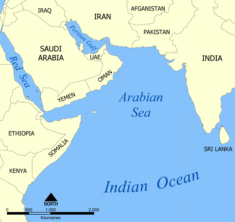
| ការពិពណ៌នា | A map showing the location of the Arabian Sea in the Indian Ocean. Created by NormanEinstein, July 19, 2005. |
| កាលបរិច្ឆេទ | |
| ប្រភព | Self-published work by NormanEinstein |
| អ្នកនិពន្ធ | NormanEinstein, Ras67 |
| ទំរង់ផ្សេងទៀត |
Derivative works of this file: |
ការដាក់អាជ្ញាប័ណ្ណ
I, the copyright holder of this work, hereby publish it under the following licenses:

|
រូបភាពនៃទំព័រនេះជាកម្មសិទ្ធិរបស់GNU Free Documentation License។ Version 1.2 ឬក៏ខ្ពស់ជាងនេះត្រូវបានឧបត្ថមគាំទ្រដោយ មូលនិធិសូហ្វវែរដោយឥតគិតថ្លៃ (Free Software Foundation) ដែលមិនមានផ្នែកណាមួយរបស់ប្រភពដើមរួមទាំងអក្សរនៅលើគំរបមុខនិងខ្នង ត្រូវបានផ្លាស់ប្តូរទេ។ ចំពោះផ្នែកដែលមិនអាចផ្លាស់ប្តូរបាន សូមមើលGNU Free Documentation License។ |
| ឯកសារនេះជាប់អាជ្ញាបណ្ឌCreative Commons Attribution-Share Alike 3.0 Unported។ | ||
| ||
| This licensing tag was added to this file as part of the GFDL licensing update. |
You may select the license of your choice.
ប្រវត្តិឯកសារ
ចុចលើម៉ោងនិងកាលបរិច្ឆេទដើម្បីមើលឯកសារដែលបានផ្ទុកឡើងនៅពេលនោះ។
| ម៉ោងនិងកាលបរិច្ឆេទ | កូនរូបភាព | វិមាត្រ | អ្នកប្រើប្រាស់ | យោបល់ | |
|---|---|---|---|---|---|
| បច្ចុប្បន្ន | ម៉ោង១១:៥៤ ថ្ងៃច័ន្ទ ទី១៣ ខែកក្កដា ឆ្នាំ២០២០ | | ៧៩៧ × ៧៥៣ (១៤៧គីឡូបៃ) | Kzl55 | Restored longstanding version |
| ម៉ោង១៤:១៣ ថ្ងៃសៅរ៍ ទី២១ ខែមីនា ឆ្នាំ២០២០ |  | ៦៣៥ × ៦០០ (១៥៥គីឡូបៃ) | Noseisnostriledd | ctl | |
| ម៉ោង២៣:៤២ ថ្ងៃព្រហស្បតិ៍ ទី១៩ ខែមីនា ឆ្នាំ២០២០ |  | ៦៣៥ × ៦០០ (១៥៥គីឡូបៃ) | Noseisnostriledd | regional sea | |
| ម៉ោង១៩:៥៨ ថ្ងៃសៅរ៍ ទី២៨ ខែធ្នូ ឆ្នាំ២០១៩ |  | ៧៩៧ × ៧៥៣ (២០០គីឡូបៃ) | Noseisnostriledd | Add detail | |
| ម៉ោង១៣:២០ ថ្ងៃព្រហស្បតិ៍ ទី១៤ ខែមេសា ឆ្នាំ២០១១ |  | ៧៩៧ × ៧៥៣ (១៤៧គីឡូបៃ) | Ras67 | cropped and squeezed | |
| ម៉ោង១៤:៣០ ថ្ងៃអង្គារ ទី១៩ ខែកក្កដា ឆ្នាំ២០០៥ |  | ៨០០ × ៧៥៧ (២២៣គីឡូបៃ) | NormanEinstein | A map showing the location of the Arabian Sea in the Indian Ocean. Created by NormanEinstein, Jully 19, 2005. {{GFDL-self}} Category:Maps of seas | |
| ម៉ោង១៤:៣០ ថ្ងៃអង្គារ ទី១៩ ខែកក្កដា ឆ្នាំ២០០៥ |  | ៨០០ × ៧៥៧ (២២៣គីឡូបៃ) | NormanEinstein | A map showing the location of the Arabian Sea in the Indian Ocean. Created by NormanEinstein, Jully 19, 2005. {{GFDL-self}} Category:Maps of seas |
បម្រើបម្រាស់ឯកសារ
ទំព័រ ខាងក្រោមប្រើប្រាស់ឯកសារនេះ ៖
បម្រើបម្រាស់ឯកសារជាសាកល
វីគីដទៃទៀតដូចខាងក្រោមនេះប្រើប្រាស់ឯកសារនេះ៖
- ការប្រើប្រាស់នៅក្នុង af.wikipedia.org
- ការប្រើប្រាស់នៅក្នុង am.wikipedia.org
- ការប្រើប្រាស់នៅក្នុង ar.wikipedia.org
- ការប្រើប្រាស់នៅក្នុង ast.wikipedia.org
- ការប្រើប្រាស់នៅក្នុង as.wikipedia.org
- ការប្រើប្រាស់នៅក្នុង az.wikipedia.org
- ការប្រើប្រាស់នៅក្នុង az.wiktionary.org
- ការប្រើប្រាស់នៅក្នុង be-tarask.wikipedia.org
- ការប្រើប្រាស់នៅក្នុង bg.wikipedia.org
- ការប្រើប្រាស់នៅក្នុង bh.wikipedia.org
- ការប្រើប្រាស់នៅក្នុង bs.wikipedia.org
- ការប្រើប្រាស់នៅក្នុង bxr.wikipedia.org
- ការប្រើប្រាស់នៅក្នុង ckb.wikipedia.org
- ការប្រើប្រាស់នៅក្នុង cs.wikipedia.org
- ការប្រើប្រាស់នៅក្នុង cv.wikipedia.org
- ការប្រើប្រាស់នៅក្នុង cy.wikipedia.org
- ការប្រើប្រាស់នៅក្នុង da.wikipedia.org
- ការប្រើប្រាស់នៅក្នុង de.wikipedia.org
- ការប្រើប្រាស់នៅក្នុង diq.wikipedia.org
- ការប្រើប្រាស់នៅក្នុង dv.wikipedia.org
- ការប្រើប្រាស់នៅក្នុង en.wikipedia.org
- ការប្រើប្រាស់នៅក្នុង eo.wikipedia.org
- ការប្រើប្រាស់នៅក្នុង es.wikipedia.org
- ការប្រើប្រាស់នៅក្នុង eu.wikipedia.org
- ការប្រើប្រាស់នៅក្នុង fa.wikipedia.org
View more global usage of this file.