
ឯកសារ:Atlas Van der Hagen-KW1049B10 047-S. IMPERIUM ROMANO-GERMANICUM oder DEUTSCHLAND MIT SEINEN ANGRÄNTZENDEN KÖNIGREICHEN UND PROVINCIEN Neulich entworffen und theils gezeichnet durch IULIUM REICHELT Chur Pfaltz.jpg
ទំហំរបស់ការមើលមុននេះ: ៧១១ × ៥៩៩ ភីកសែ។ ភាពម៉ត់ផ្សេងទៀត៖ ២៨៥ × ២៤០ ភីកសែ | ៥៦៩ × ៤៨០ ភីកសែ | ៩១១ × ៧៦៨ ភីកសែ | ១២១៥ × ១០២៤ ភីកសែ | ២៤២៩ × ២០៤៨ ភីកសែ | ៥៥០០ × ៤៦៣៧ ភីកសែ។
រូបភាពដើម (៥៥០០ × ៤៦៣៧ ភីកសែល ទំហំឯកសារ៖ ៥.៤៩មេកាបៃ ប្រភេទ MIME៖ image/jpeg)
ចំណារពន្យល់
| Dirk Jansz van Santen: Atlas van Dirk van der Hagen (volledig, collectie KB)
|
|||||||||||||||||||||||||||
|---|---|---|---|---|---|---|---|---|---|---|---|---|---|---|---|---|---|---|---|---|---|---|---|---|---|---|---|
| វិចិត្រករ |
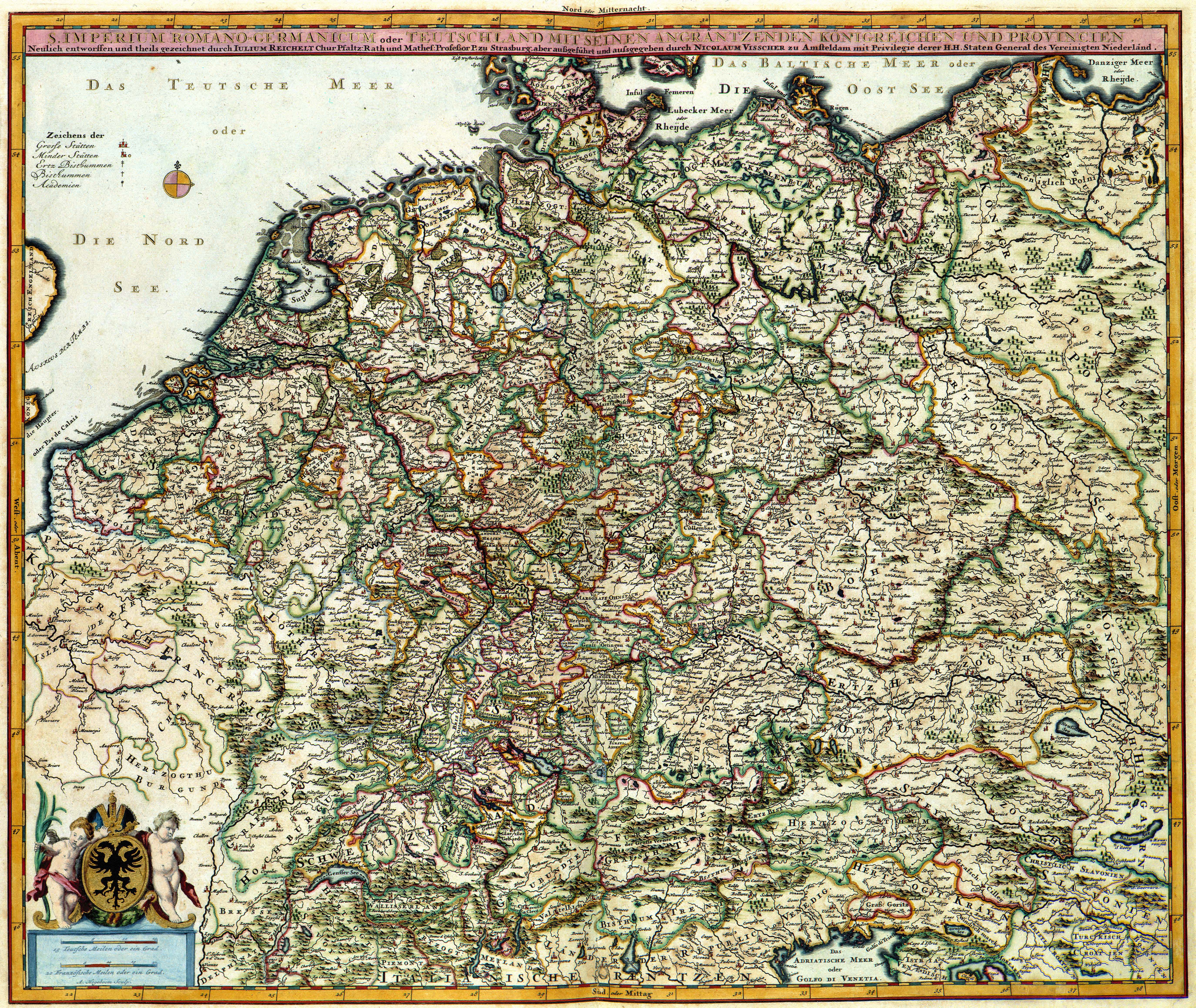
Julius Reichelt Author: Julius Reichelt Publisher:
|
 | |||||||||||||||||||||||||
| ចំណងជើង |
S. IMPERIUM ROMANO-GERMANICUM oder DEUTSCHLAND MIT SEINEN ANGRÄNTZENDEN KÖNIGREICHEN UND PROVINCIEN Neulich entworffen und theils gezeichnet durch IULIUM REICHELT Chur Pfaltz |
||||||||||||||||||||||||||
| Object type | |||||||||||||||||||||||||||
| ការពិពណ៌នា |
Nederlands: Deze kaart van het Duitse Rijk werd ontworpen door Julius Reichelt (1637-1717). Van Reichelt is weinig meer bekend dan dat hij hoogleraar in de wiskunde aan de Universiteit van Straatsburg was. Van zijn kaart verschenen tijdens de 17de en 18de eeuw verschillende bewerkingen. Deze bewerking is van de hand van de uitgever Nicolaes Visscher II (1649-1702).
English: This map of the German Empire was designed by Julius Reichelt (1637-1717). Reichelt was professor of mathematics at the University of Strassburg. During the 18th century many derivations appeared. This reproduction was published by Nicolaes Visscher II (1649-1702). |
||||||||||||||||||||||||||
| ភាសា |
ភាសាហូឡង់ |
||||||||||||||||||||||||||
| កាលបរិច្ឆេទ | after ១៦៨១ | ||||||||||||||||||||||||||
| កាលបរិច្ឆេទបោះពុម្ពផ្សាយ |
circa |
||||||||||||||||||||||||||
| មធ្យម |
Nederlands: kopergravure
English: copper engraving print |
||||||||||||||||||||||||||
| វិមាត្រ | 47 x 56 cm | ||||||||||||||||||||||||||
| Collection |
|
||||||||||||||||||||||||||
| អត្តលេខ |
Description of the Atlas Van der Hagen in the catalogue of the KB: http://opc4.kb.nl/DB=1/TTL=1/LNG=EN/PPN?PPN=353012750 |
||||||||||||||||||||||||||
| Place of creation | Amsterdam | ||||||||||||||||||||||||||
| កំនត់ចំណាំ | KW1049B10_047 - Volume 1 | ||||||||||||||||||||||||||
| Related persons | Nicolaes Visscher II - Reichelt, Julius | ||||||||||||||||||||||||||
| Depicted locations | German Empire | ||||||||||||||||||||||||||
| ឯកសារយោង | |||||||||||||||||||||||||||
| ប្រភព/ជាងថតរូប |
Source page at the Geheugen van Nederland / Memory of the Netherlands website.
|
||||||||||||||||||||||||||

ការដាក់អាជ្ញាប័ណ្ណ
|
This is a faithful photographic reproduction of a two-dimensional, public domain work of art. The work of art itself is in the public domain for the following reason:
The official position taken by the Wikimedia Foundation is that "faithful reproductions of two-dimensional public domain works of art are public domain".
This photographic reproduction is therefore also considered to be in the public domain in the United States. In other jurisdictions, re-use of this content may be restricted; see Reuse of PD-Art photographs for details. | ||||
ប្រវត្តិឯកសារ
ចុចលើម៉ោងនិងកាលបរិច្ឆេទដើម្បីមើលឯកសារដែលបានផ្ទុកឡើងនៅពេលនោះ។
| ម៉ោងនិងកាលបរិច្ឆេទ | កូនរូបភាព | វិមាត្រ | អ្នកប្រើប្រាស់ | យោបល់ | |
|---|---|---|---|---|---|
| បច្ចុប្បន្ន | ម៉ោង០៤:២១ ថ្ងៃអាទិត្យ ទី១៩ ខែកក្កដា ឆ្នាំ២០១៥ | | ៥៥០០ × ៤៦៣៧ (៥.៤៩មេកាបៃ) | OlafJanssen | GWToolset: Creating mediafile for OlafJanssen. |
បម្រើបម្រាស់ឯកសារ
ទំព័រ ខាងក្រោមប្រើប្រាស់ឯកសារនេះ ៖
បម្រើបម្រាស់ឯកសារជាសាកល
វីគីដទៃទៀតដូចខាងក្រោមនេះប្រើប្រាស់ឯកសារនេះ៖
- ការប្រើប្រាស់នៅក្នុង be-tarask.wikipedia.org
- ការប្រើប្រាស់នៅក្នុង bn.wikipedia.org
- ការប្រើប្រាស់នៅក្នុង bs.wikipedia.org
- ការប្រើប្រាស់នៅក្នុង ckb.wikipedia.org
- ការប្រើប្រាស់នៅក្នុង en.wikipedia.org
- German Empire
- East Germany
- History of Germany
- Holy Roman Empire
- Nazi Germany
- West Germany
- Weimar Republic
- Flight and expulsion of Germans (1944–1950)
- German reunification
- German diaspora
- German Confederation
- Kingdom of Prussia
- North German Confederation
- History of Germany (1945–1990)
- German Reich
- Francia
- Template:History of Germany sidebar
- Confederation of the Rhine
- List of years in Germany
- East Francia
- Allied-occupied Germany
- Military history of Germany
- Kingdom of Germany
- Kleinstaaterei
- History of German
- History of Germany during World War I
- Economic history of Germany
- History of Saxony
- Names of Germany
View more global usage of this file.