
ឯកសារ:Bangladesh LOC 1996 map.jpg

ទំហំរបស់ការមើលមុននេះ: ៤៧៨ × ៥៩៩ ភីកសែ។ ភាពម៉ត់ផ្សេងទៀត៖ ១៩១ × ២៤០ ភីកសែ | ៣៨៣ × ៤៨០ ភីកសែ | ៦១៣ × ៧៦៨ ភីកសែ | ៨១៧ × ១០២៤ ភីកសែ | ១៥៩៦ × ២០០០ ភីកសែ។
រូបភាពដើម (១៥៩៦ × ២០០០ ភីកសែល ទំហំឯកសារ៖ ១.៥មេកាបៃ ប្រភេទ MIME៖ image/jpeg)
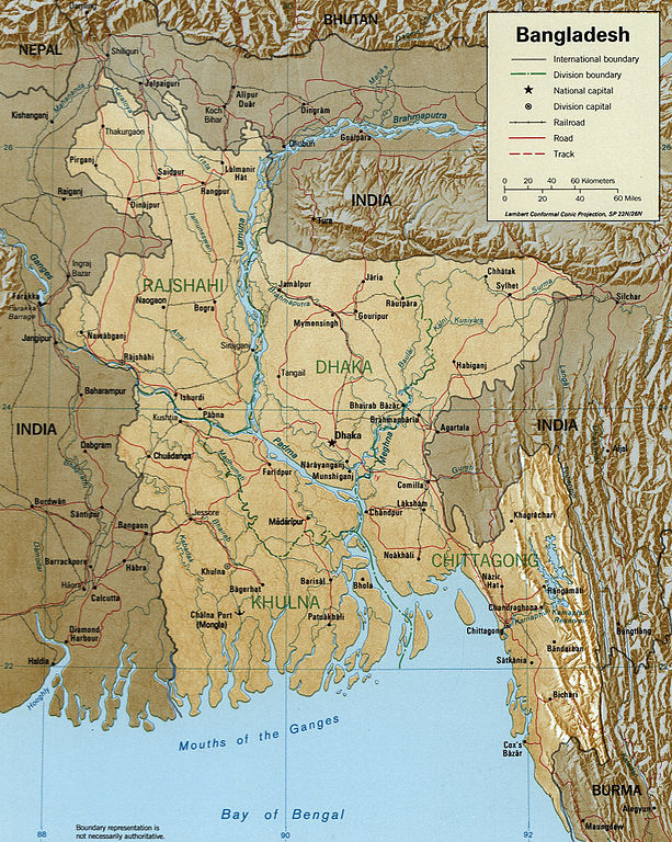
Map of Bangladesh.
http://hdl.loc.gov/loc.gmd/g7645.ct001002
This work is in the public domain in the United States because it is a work prepared by an officer or employee of the United States Government as part of that person’s official duties under the terms of Title 17, Chapter 1, Section 105 of the US Code.
Note: This only applies to original works of the Federal Government and not to the work of any individual U.S. state, territory, commonwealth, county, municipality, or any other subdivision. This template also does not apply to postage stamp designs published by the United States Postal Service since 1978. (See § 313.6(C)(1) of Compendium of U.S. Copyright Office Practices). It also does not apply to certain US coins; see The US Mint Terms of Use.
|
 | |
| This file has been identified as being free of known restrictions under copyright law, including all related and neighboring rights. | ||
ប្រវត្តិឯកសារ
ចុចលើម៉ោងនិងកាលបរិច្ឆេទដើម្បីមើលឯកសារដែលបានផ្ទុកឡើងនៅពេលនោះ។
| ម៉ោងនិងកាលបរិច្ឆេទ | កូនរូបភាព | វិមាត្រ | អ្នកប្រើប្រាស់ | យោបល់ | |
|---|---|---|---|---|---|
| បច្ចុប្បន្ន | ម៉ោង១៩:៥៦ ថ្ងៃអង្គារ ទី២៥ ខែតុលា ឆ្នាំ២០០៥ | | ១៥៩៦ × ២០០០ (១.៥មេកាបៃ) | Brian0918 | Map of Bangladesh. http://hdl.loc.gov/loc.gmd/g7645.ct001002 {{PD-USGov}} Category:Maps of Bangladesh |
បម្រើបម្រាស់ឯកសារ
គ្មានទំព័រណាមួយដែលប្រើប្រាស់ឯកសារនេះទេ។
បម្រើបម្រាស់ឯកសារជាសាកល
វីគីដទៃទៀតដូចខាងក្រោមនេះប្រើប្រាស់ឯកសារនេះ៖
- ការប្រើប្រាស់នៅក្នុង als.wikipedia.org
- ការប្រើប្រាស់នៅក្នុង as.wikipedia.org
- ការប្រើប្រាស់នៅក្នុង bg.wikipedia.org
- ការប្រើប្រាស់នៅក្នុង bh.wikipedia.org
- ការប្រើប្រាស់នៅក្នុង bn.wikipedia.org
- ការប្រើប្រាស់នៅក្នុង ca.wikipedia.org
- ការប្រើប្រាស់នៅក្នុង el.wikipedia.org
- ការប្រើប្រាស់នៅក្នុង en.wikipedia.org
- ការប្រើប្រាស់នៅក្នុង eo.wikipedia.org
- ការប្រើប្រាស់នៅក្នុង es.wikipedia.org
- ការប្រើប្រាស់នៅក្នុង fi.wikipedia.org
- ការប្រើប្រាស់នៅក្នុង fr.wikipedia.org
- ការប្រើប្រាស់នៅក្នុង gl.wikipedia.org
- ការប្រើប្រាស់នៅក្នុង gu.wikipedia.org
- ការប្រើប្រាស់នៅក្នុង hif.wikipedia.org
- ការប្រើប្រាស់នៅក្នុង hi.wikipedia.org
- ការប្រើប្រាស់នៅក្នុង hr.wiktionary.org
- ការប្រើប្រាស់នៅក្នុង hu.wikipedia.org
- ការប្រើប្រាស់នៅក្នុង id.wikipedia.org
- ការប្រើប្រាស់នៅក្នុង it.wikipedia.org
View more global usage of this file.