
ឯកសារ:France population density 40pc.png

ទំហំរបស់ការមើលមុននេះ: ៣៧០ × ៥៩៩ ភីកសែ។ ភាពម៉ត់ផ្សេងទៀត៖ ១៤៨ × ២៤០ ភីកសែ | ២៩៦ × ៤៨០ ភីកសែ | ៤៧៤ × ៧៦៨ ភីកសែ | ១២៤៦ × ២០១៨ ភីកសែ។
រូបភាពដើម (១២៤៦ × ២០១៨ ភីកសែល ទំហំឯកសារ៖ ៥៣៧គីឡូបៃ ប្រភេទ MIME៖ image/png)
ចំណារពន្យល់
| ការពិពណ៌នា |
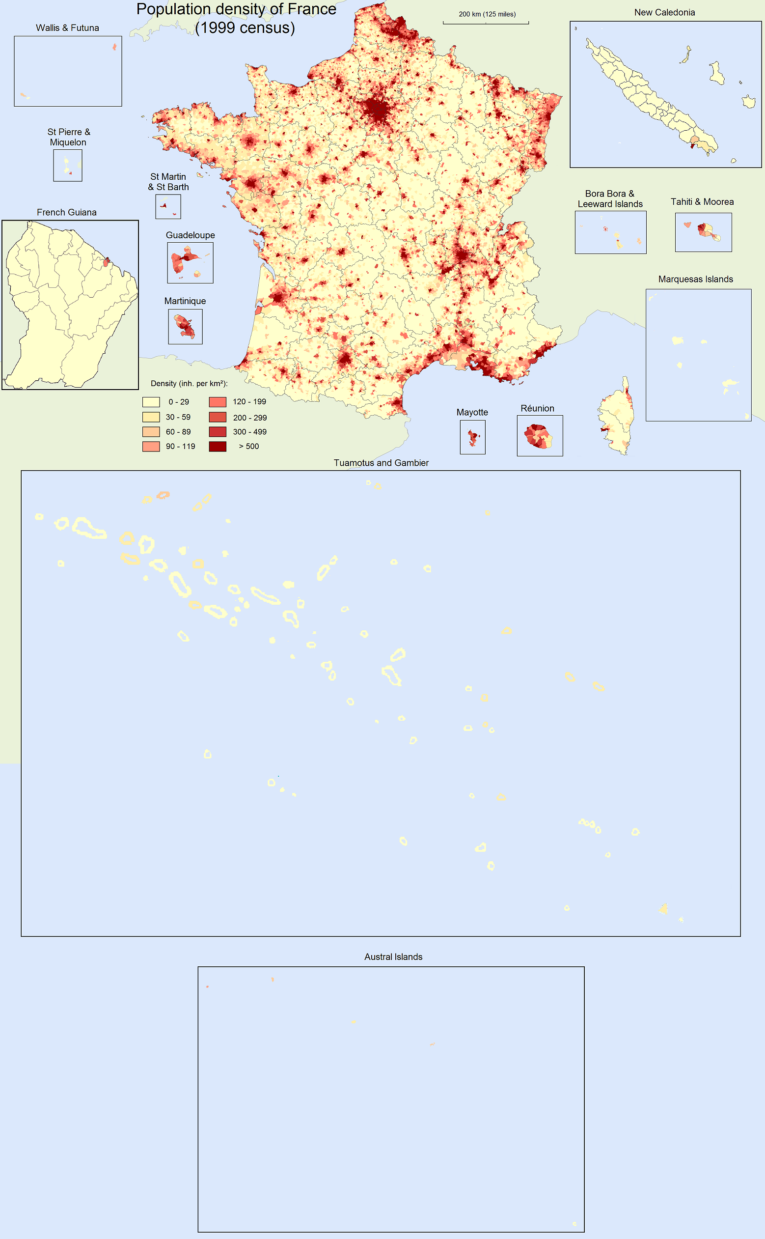
English: Population density map of France (40% of original). For the original (more detailed) version of the map, see: France_population_density.png.
Density is as of 1999 census for Metropolitan France, Réunion, French Guiana, Martinique, Guadeloupe, St Martin & St Barth, and St Pierre & Miquelon. Density is as of 2002 census for Mayotte, Tahiti & Moorea, Bora Bora & Leeward Islands, Marquesas Islands, Tuamotus & Gambier, and Austral Islands. Density is as of 2003 census for Wallis & Futuna. Density is as of 2004 census for New Caledonia. |
| កាលបរិច្ឆេទ | |
| ប្រភព | ការងារផ្ទាល់របស់អ្នកផ្ទុកឡើង |
| អ្នកនិពន្ធ | Der Statistiker |
ការដាក់អាជ្ញាប័ណ្ណ
I, the copyright holder of this work, hereby publish it under the following licenses:
ឯកសារនេះជាប់អាជ្ញាបណ្ឌCreative Commons Attribution-Share Alike 3.0 Unported។
- អ្នកមានសិទ្ធិ៖
- ចែកចាយ – ថតចំលងនិងចែកចាយស្នាដៃនេះ
- កែច្នៃ – កែច្នៃយកទៅប្រើ
- ក្រោមលក្ខខណ្ឌដូចតទៅនេះ៖
- ភាពជាម្ចាស់កម្មសិទ្ធ – You must give appropriate credit, provide a link to the license, and indicate if changes were made. You may do so in any reasonable manner, but not in any way that suggests the licensor endorses you or your use.
- share alike – If you remix, transform, or build upon the material, you must distribute your contributions under the same or compatible license as the original.

|
រូបភាពនៃទំព័រនេះជាកម្មសិទ្ធិរបស់GNU Free Documentation License។ Version 1.2 ឬក៏ខ្ពស់ជាងនេះត្រូវបានឧបត្ថមគាំទ្រដោយ មូលនិធិសូហ្វវែរដោយឥតគិតថ្លៃ (Free Software Foundation) ដែលមិនមានផ្នែកណាមួយរបស់ប្រភពដើមរួមទាំងអក្សរនៅលើគំរបមុខនិងខ្នង ត្រូវបានផ្លាស់ប្តូរទេ។ ចំពោះផ្នែកដែលមិនអាចផ្លាស់ប្តូរបាន សូមមើលGNU Free Documentation License។ |
You may select the license of your choice.
ប្រវត្តិឯកសារ
ចុចលើម៉ោងនិងកាលបរិច្ឆេទដើម្បីមើលឯកសារដែលបានផ្ទុកឡើងនៅពេលនោះ។
| ម៉ោងនិងកាលបរិច្ឆេទ | កូនរូបភាព | វិមាត្រ | អ្នកប្រើប្រាស់ | យោបល់ | |
|---|---|---|---|---|---|
| បច្ចុប្បន្ន | ម៉ោង២០:៥៤ ថ្ងៃច័ន្ទ ទី០១ ខែធ្នូ ឆ្នាំ២០០៨ | | ១២៤៦ × ២០១៨ (៥៣៧គីឡូបៃ) | Der Statistiker | {{Information |Description={{en|1=Population density map of France, made by myself.}} |Source=Own work by uploader |Author=Der Statistiker |Date=December 1, 2008 |Permission= |other_versions= }} <!--{{ImageUpload|full}}--> |
បម្រើបម្រាស់ឯកសារ
ទំព័រ ខាងក្រោមប្រើប្រាស់ឯកសារនេះ ៖
បម្រើបម្រាស់ឯកសារជាសាកល
វីគីដទៃទៀតដូចខាងក្រោមនេះប្រើប្រាស់ឯកសារនេះ៖
- ការប្រើប្រាស់នៅក្នុង ar.wikipedia.org
- ការប្រើប្រាស់នៅក្នុង azb.wikipedia.org
- ការប្រើប្រាស់នៅក្នុង az.wikipedia.org
- ការប្រើប្រាស់នៅក្នុង cs.wikipedia.org
- ការប្រើប្រាស់នៅក្នុង en.wikipedia.org
- ការប្រើប្រាស់នៅក្នុង fr.wikipedia.org
- ការប្រើប្រាស់នៅក្នុង hy.wikipedia.org
- ការប្រើប្រាស់នៅក្នុង id.wikipedia.org
- ការប្រើប្រាស់នៅក្នុង jv.wikipedia.org
- ការប្រើប្រាស់នៅក្នុង lt.wikipedia.org
- ការប្រើប្រាស់នៅក្នុង pl.wikipedia.org
- ការប្រើប្រាស់នៅក្នុង pt.wikipedia.org
- ការប្រើប្រាស់នៅក្នុង szl.wikipedia.org
- ការប្រើប្រាស់នៅក្នុង te.wikipedia.org
- ការប្រើប្រាស់នៅក្នុង tr.wikipedia.org
- ការប្រើប្រាស់នៅក្នុង uk.wikipedia.org
- ការប្រើប្រាស់នៅក្នុង vi.wikipedia.org
- ការប្រើប្រាស់នៅក្នុង zh.wikipedia.org