
ឯកសារ:Hercynides EN.svg

Size of this PNG preview of this SVG file: ៥៥០ × ៣៧០ ភីកសែ. ភាពម៉ត់ផ្សេងទៀត៖ ៣២០ × ២១៥ ភីកសែ | ៦៤០ × ៤៣១ ភីកសែ | ១០២៤ × ៦៨៩ ភីកសែ | ១២៨០ × ៨៦១ ភីកសែ | ២៥៦០ × ១៧២២ ភីកសែ។
រូបភាពដើម (ឯកសារប្រភេទSVG ៥៥០ × ៣៧០ ភីកសែល ទំហំឯកសារ៖ ១០៨គីឡូបៃ)
ចំណារពន្យល់
| ការពិពណ៌នា |
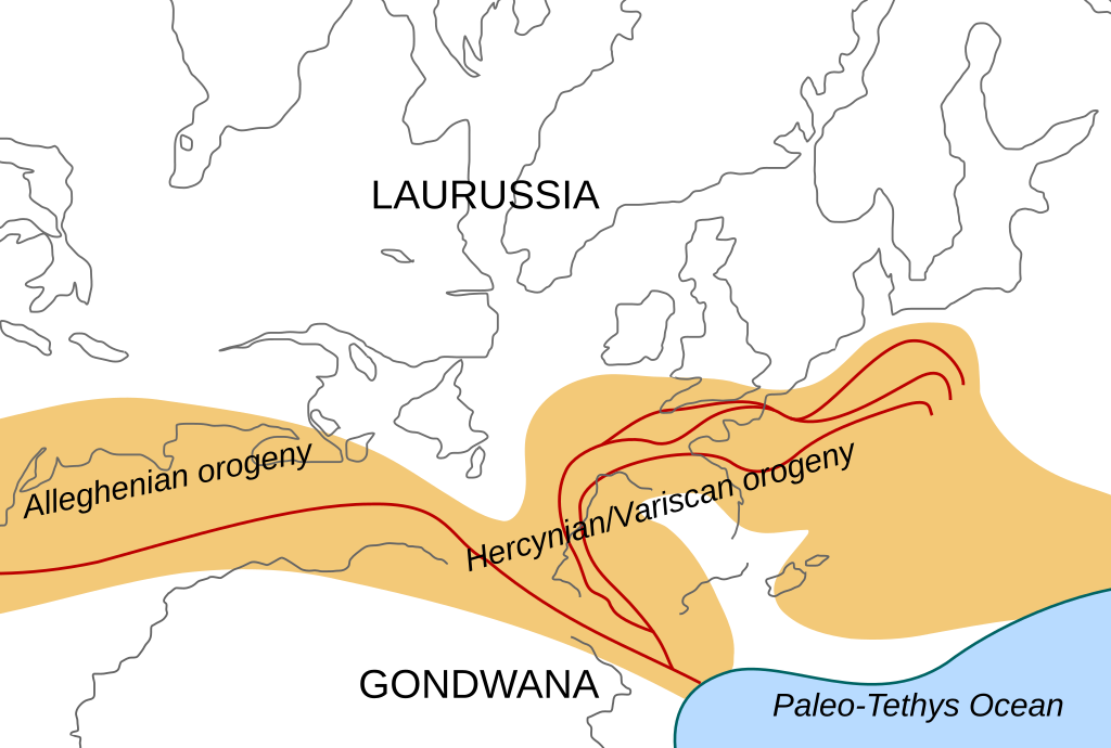
English: Location of the Hercynian/Variscan/Alleghanian mountain chains in the middle of the Carboniferous period. Present day coastlines are shown for reference. Red lines are sutures, capitalized names are the different continents that joined during these orogenies.
Literature used to make this map:
|
| កាលបរិច្ឆេទ | |
| ប្រភព | ការងារផ្ទាល់របស់អ្នកផ្ទុកឡើង |
| អ្នកនិពន្ធ | Woudloper |
| ទំរង់ផ្សេងទៀត |
Derivative works of this file: Image:Hercynides NL.svg, Image:Hercynides DE.svg, Image:Hercynides IT.svg |

|
ហ្វាល់ SVG នេះបង្កប់ឃ្លាជាអក្សរដែលអាចឲ្យអ្នកងាយស្រួលបកប្រែជាភាសារបស់អ្នក។ ព័ត៌មានលំអិត (ជាភាសាអង់គ្លេស) ចំពោះរូបភាព SVG អ្នកអាចប្រើ[toolforge:svgtranslate/File:Hercynides_EN.svglink ទំព័រនេះ] ដើម្បីបកប្រែវាជាភាសារបស់អ្នក។ |
ការដាក់អាជ្ញាប័ណ្ណ
ឯកសារនេះជាប់អាជ្ញាបណ្ឌCreative Commons Attribution-Share Alike 1.0 Generic។
- អ្នកមានសិទ្ធិ៖
- ចែកចាយ – ថតចំលងនិងចែកចាយស្នាដៃនេះ
- កែច្នៃ – កែច្នៃយកទៅប្រើ
- ក្រោមលក្ខខណ្ឌដូចតទៅនេះ៖
- ភាពជាម្ចាស់កម្មសិទ្ធ – You must give appropriate credit, provide a link to the license, and indicate if changes were made. You may do so in any reasonable manner, but not in any way that suggests the licensor endorses you or your use.
- share alike – If you alter, transform, or build upon this work, you must distribute the resulting work under the same license as the original.
ប្រវត្តិឯកសារ
ចុចលើម៉ោងនិងកាលបរិច្ឆេទដើម្បីមើលឯកសារដែលបានផ្ទុកឡើងនៅពេលនោះ។
| ម៉ោងនិងកាលបរិច្ឆេទ | កូនរូបភាព | វិមាត្រ | អ្នកប្រើប្រាស់ | យោបល់ | |
|---|---|---|---|---|---|
| បច្ចុប្បន្ន | ម៉ោង១៩:២៩ ថ្ងៃអង្គារ ទី០២ ខែធ្នូ ឆ្នាំ២០០៨ | | ៥៥០ × ៣៧០ (១០៨គីឡូបៃ) | Woudloper | {{Information |Description={{en|1=Location of the Hercynian/Variscan/Alleghanian mountain chains in the middle of the Carboniferous period. Present day coastlines are shown for reference. Red lines are sutures, capitalized names are the different continen |
បម្រើបម្រាស់ឯកសារ
គ្មានទំព័រណាមួយដែលប្រើប្រាស់ឯកសារនេះទេ។
បម្រើបម្រាស់ឯកសារជាសាកល
វីគីដទៃទៀតដូចខាងក្រោមនេះប្រើប្រាស់ឯកសារនេះ៖
- ការប្រើប្រាស់នៅក្នុង ca.wikipedia.org
- ការប្រើប្រាស់នៅក្នុង en.wikipedia.org
- ការប្រើប្រាស់នៅក្នុង fa.wikipedia.org
- ការប្រើប្រាស់នៅក្នុង fr.wikipedia.org
- ការប្រើប្រាស់នៅក្នុង gl.wikipedia.org
- ការប្រើប្រាស់នៅក្នុង nn.wikipedia.org
- ការប្រើប្រាស់នៅក្នុង pl.wikipedia.org
- ការប្រើប្រាស់នៅក្នុង ro.wikipedia.org
- ការប្រើប្រាស់នៅក្នុង tr.wikipedia.org
- ការប្រើប្រាស់នៅក្នុង zh.wikipedia.org