
ឯកសារ:Map of Europe (political).png
រូបភាពដើម (១៥៩៦ × ១០៤៣ ភីកសែល ទំហំឯកសារ៖ ៨៦គីឡូបៃ ប្រភេទ MIME៖ image/png)
.png)

|
This map has been uploaded by Electionworld from en.wikipedia.org to enable the |
ចំណារពន្យល់
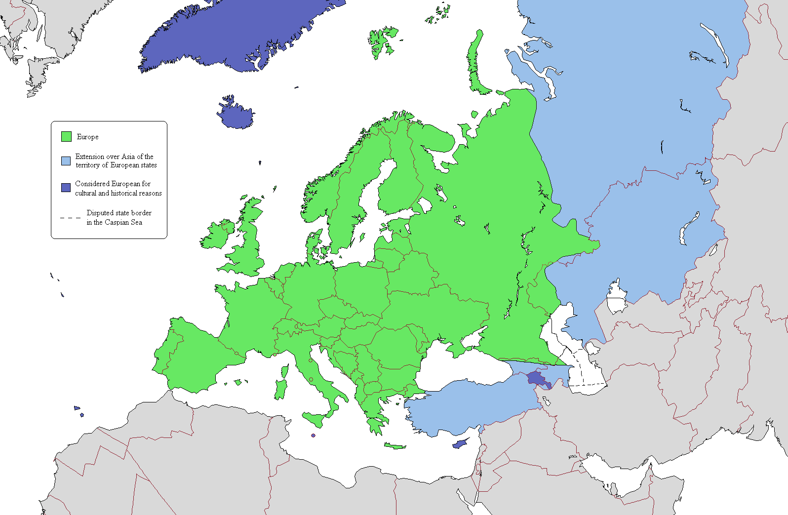
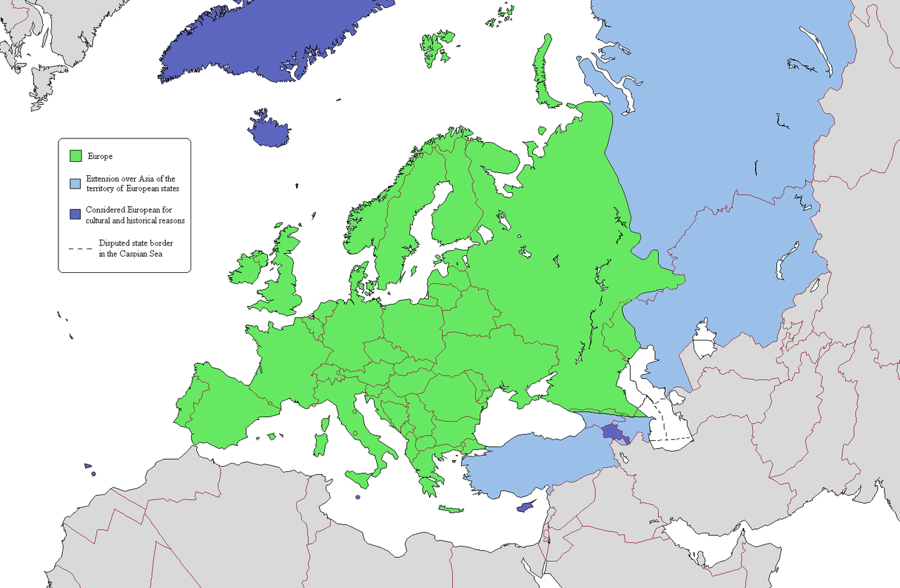
This is a map intended to show the continental boundary of Europe, and the territory of transcontinental states. The map is flawed in a number of ways, and a corrected version is found at [[: File:Europe Asia transcontinental.png]]. Since the latter is a derived version of this one, a copy of the flawed map should be kept around for licencing reasons. The original map appears to have been uploaded to Wikipedia in 2006 by en:User:Alinor.
Derivative works of this file: Europe Asia transcontinental.png
Derivative works of this file: Map of Europe 2007 (political) de.png
_de.png)

|
រូបភាព mapនេះ គួរតែបង្កើតឡើងវិញដោយប្រើក្រាភិកវ៉ិចទ័រ ដែលជាប្រភេទហ្វាល់ SVG ។ ការបង្កើតរូបភាពជាហ្វាល់ SVG ផ្តល់នូវអត្ថប្រយោជន៍ជាច្រើន។ ចំពោះព័ត៌មានបន្ថែម សូមមើល Commons:Media for cleanup ។ ប្រសិនបើទំរង់ SVG នៃរូបភាពនេះត្រូវបានបង្កើតរួចរាល់ហើយ សូមអាប់ឡូដវា។ បន្ទាប់ពីអាប់ឡូដជាទំរង់ SVG សូមជំនួសទំព័រគំរូនេះដោយ {{vector version available|ឈ្មោះរូបភាពថ្មី.svg}} ។
|
ការដាក់អាជ្ញាប័ណ្ណ

|
រូបភាពនៃទំព័រនេះជាកម្មសិទ្ធិរបស់GNU Free Documentation License។ Version 1.2 ឬក៏ខ្ពស់ជាងនេះត្រូវបានឧបត្ថមគាំទ្រដោយ មូលនិធិសូហ្វវែរដោយឥតគិតថ្លៃ (Free Software Foundation) ដែលមិនមានផ្នែកណាមួយរបស់ប្រភពដើមរួមទាំងអក្សរនៅលើគំរបមុខនិងខ្នង ត្រូវបានផ្លាស់ប្តូរទេ។ ចំពោះផ្នែកដែលមិនអាចផ្លាស់ប្តូរបាន សូមមើលGNU Free Documentation License។ |
| ឯកសារនេះជាប់អាជ្ញាបណ្ឌCreative Commons Attribution-Share Alike 3.0 Unported។ | ||
| ||
| This licensing tag was added to this file as part of the GFDL licensing update. |
ប្រវត្តិឯកសារ
ចុចលើម៉ោងនិងកាលបរិច្ឆេទដើម្បីមើលឯកសារដែលបានផ្ទុកឡើងនៅពេលនោះ។
.png&dir=prev)
.png&offset=20110409134150)
.png&offset=&limit=20)
.png&offset=&limit=50)
.png&offset=&limit=100)
.png&offset=&limit=250)
.png&offset=&limit=500)
| ម៉ោងនិងកាលបរិច្ឆេទ | កូនរូបភាព | វិមាត្រ | អ្នកប្រើប្រាស់ | យោបល់ | |
|---|---|---|---|---|---|
| បច្ចុប្បន្ន | ម៉ោង២២:០៣ ថ្ងៃព្រហស្បតិ៍ ទី២០ ខែមិថុនា ឆ្នាំ២០១៩ | | ១៥៩៦ × ១០៤៣ (៨៦គីឡូបៃ) | Rs4815 | Border in the south-east passes along the Greater Caucasus Range |
| ម៉ោង០៤:០៥ ថ្ងៃសៅរ៍ ទី១៦ ខែមេសា ឆ្នាំ២០១១ |  | ១៥៩៦ × ១០៤៣ (១០៧គីឡូបៃ) | Wsiegmund | Reverted to version as of 19:16, 13 November 2009; see http://commons.wikimedia.org/w/index.php?title=User_talk:Wsiegmund&oldid=53219388#File:Map_of_Europe_.28political.29.png | |
| ម៉ោង០៣:២៨ ថ្ងៃពុធ ទី១៣ ខែមេសា ឆ្នាំ២០១១ |  | ១៥៩៦ × ១០៤៣ (៧១គីឡូបៃ) | Green, White and Gold | Reverted to Dbachmann's version as of 11:49, 8 April 2011 | |
| ម៉ោង០២:៣៧ ថ្ងៃពុធ ទី១៣ ខែមេសា ឆ្នាំ២០១១ |  | ១៥៩៦ × ១០៤៣ (៧១គីឡូបៃ) | Gerge | Reverted to version as of 06:06, 12 April 2011 | |
| ម៉ោង២៣:១២ ថ្ងៃអង្គារ ទី១២ ខែមេសា ឆ្នាំ២០១១ |  | ១៥៩៦ × ១០៤៣ (៧១គីឡូបៃ) | Green, White and Gold | Reverted to Dbachmann's version as of 11:49, 8 April 2011 | |
| ម៉ោង២៣:០៩ ថ្ងៃអង្គារ ទី១២ ខែមេសា ឆ្នាំ២០១១ |  | ១៥៩៦ × ១០៤៣ (១០៧គីឡូបៃ) | Green, White and Gold | Reverted to Dbachmann's version as of 13:41, 9 April 2011 | |
| ម៉ោង០៦:០៦ ថ្ងៃអង្គារ ទី១២ ខែមេសា ឆ្នាំ២០១១ |  | ១៥៩៦ × ១០៤៣ (៧១គីឡូបៃ) | Sigismun | Reverted to version as of 19:54, 10 April 2011 | |
| ម៉ោង០១:០៦ ថ្ងៃអង្គារ ទី១២ ខែមេសា ឆ្នាំ២០១១ |  | ១៥៩៦ × ១០៤៣ (១០៧គីឡូបៃ) | Green, White and Gold | Reverted to Dbachmann's version as of 13:41, 9 April 2011 | |
| ម៉ោង១៩:៥៤ ថ្ងៃអាទិត្យ ទី១០ ខែមេសា ឆ្នាំ២០១១ |  | ១៥៩៦ × ១០៤៣ (៧១គីឡូបៃ) | ComtesseDeMingrelie | rv. per Commons:Avoid overwriting existing files | |
| ម៉ោង១៣:៤១ ថ្ងៃសៅរ៍ ទី០៩ ខែមេសា ឆ្នាំ២០១១ |  | ១៥៩៦ × ១០៤៣ (១០៧គីឡូបៃ) | Dbachmann | so, since this map is going to be useless anyway, rv to 3 February 2009 per "Commons:Avoid overwriting existing files." |
បម្រើបម្រាស់ឯកសារ
គ្មានទំព័រណាមួយដែលប្រើប្រាស់ឯកសារនេះទេ។
បម្រើបម្រាស់ឯកសារជាសាកល
វីគីដទៃទៀតដូចខាងក្រោមនេះប្រើប្រាស់ឯកសារនេះ៖
- ការប្រើប្រាស់នៅក្នុង cs.wikipedia.org
- ការប្រើប្រាស់នៅក្នុង da.wikipedia.org
- ការប្រើប្រាស់នៅក្នុង de.wikipedia.org
- ការប្រើប្រាស់នៅក្នុង en.wikipedia.org
- User:Rashed
- User:Siyavash
- User:Kenzilla
- User:Australian Jezza
- Template:User Eurasian
- User:WiKID Daryl
- User:Royaljared
- User:Angelo De La Paz
- User:PinkPanthress
- Talk:Georgia/Archive 1
- User:Finlandlover
- User talk:BadYodels
- User:Tweisbach
- User:Obaidz96/UBX
- User:Czar Choi
- User:Lenoxus/Subpages/Public/Old
- User:Masumisyan
- User:PKLion
- User:Sweet & Sour Grapes
- User:Shakarian141
- User:Niceguy90
- User:Epileptic Mushroom
- Talk:Armenia/Archive 5
- User:Alexander Rudik
- User:Kunayev
- User:Bush111
- Wikipedia:Graphics Lab/Map workshop/Archive/Apr 2010
- Template talk:Passports/Archive 1
- User:Bgh1111
- User:Lukex115
- User:Lukex115/Userboxen
- User:RussLover
- User:Jextredo
- User:Azndrumsticks
- User:Katangais/Travel
- Wikipedia:Userboxes/Life/Ethnicity
- User:Slawful Justice
- User:Weidorje
- User:Alfredcranham
- User:Chinggis6/Tengerid Traits
- ការប្រើប្រាស់នៅក្នុង es.wikipedia.org
- ការប្រើប្រាស់នៅក្នុង fr.wikipedia.org
- ការប្រើប្រាស់នៅក្នុង it.wikipedia.org
- ការប្រើប្រាស់នៅក្នុង ko.wikipedia.org
- ការប្រើប្រាស់នៅក្នុង mk.wikipedia.org
- ការប្រើប្រាស់នៅក្នុង pl.wikipedia.org
View more global usage of this file.
.png)
.png)