
ឯកសារ:Map of Timor-Leste - administrative (since 2015) - Municípios and Posto Administrativos (with names).png

ទំហំរបស់ការមើលមុននេះ: ៨០០ × ៣៤៤ ភីកសែ។ ភាពម៉ត់ផ្សេងទៀត៖ ៣២០ × ១៣៨ ភីកសែ | ៦៤០ × ២៧៥ ភីកសែ | ១០២៤ × ៤៤០ ភីកសែ | ១២៨០ × ៥៥០ ភីកសែ | ២៥៦០ × ១១០១ ភីកសែ | ៧៣២៨ × ៣១៥១ ភីកសែ។
រូបភាពដើម (៧៣២៨ × ៣១៥១ ភីកសែល ទំហំឯកសារ៖ ១.១១មេកាបៃ ប្រភេទ MIME៖ image/png)
_-_Munic%C3%ADpios_and_Posto_Administrativos_(with_names).png)
ចំណារពន្យល់
| ការពិពណ៌នា |
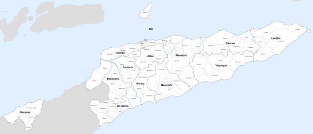
Deutsch: Karte von Osttimor mit den administrativen Grenzen seit 2015
English: Map of East Timor with the new administrative borders since 2015 |
| កាលបរិច្ឆេទ | see file history |
| ប្រភព | Own work using: information from the Ministério da Administração Estatal with maps (click 'Serviços' > 'Administração Municipal' and then choose the Município and the Posto Administrativo you want) |
| អ្នកនិពន្ធ | Maximilian Dörrbecker (Chumwa) |
| ការអនុញ្ញាត (ប្រើឯកសារនេះឡើងវិញ) |
I, the copyright holder of this work, hereby publish it under the following license: ឯកសារនេះជាប់អាជ្ញាបណ្ឌCreative Commons Attribution-Share Alike 2.5 Generic។
Sie dürfen das Bild zu den folgenden Bedingungen nutzen:
|
ប្រវត្តិឯកសារ
ចុចលើម៉ោងនិងកាលបរិច្ឆេទដើម្បីមើលឯកសារដែលបានផ្ទុកឡើងនៅពេលនោះ។
| ម៉ោងនិងកាលបរិច្ឆេទ | កូនរូបភាព | វិមាត្រ | អ្នកប្រើប្រាស់ | យោបល់ | |
|---|---|---|---|---|---|
| បច្ចុប្បន្ន | ម៉ោង១៩:២២ ថ្ងៃព្រហស្បតិ៍ ទី១៩ ខែតុលា ឆ្នាំ២០១៧ | | ៧៣២៨ × ៣១៥១ (១.១១មេកាបៃ) | Chumwa | |
| ម៉ោង២០:០៩ ថ្ងៃសៅរ៍ ទី១៤ ខែតុលា ឆ្នាំ២០១៧ |  | ៧៣២៨ × ៣១៥១ (១.១១មេកាបៃ) | Chumwa | == {{int:filedesc}} == {{Information | Description = {{de|1=Karte von Osttimor mit den administrativen Grenzen seit 2015}} {{en|1=Map of East Timor with the new administrative borders since 2015}} |Source = {{own using}} information from the [... |
បម្រើបម្រាស់ឯកសារ
ទំព័រ ខាងក្រោមប្រើប្រាស់ឯកសារនេះ ៖
បម្រើបម្រាស់ឯកសារជាសាកល
វីគីដទៃទៀតដូចខាងក្រោមនេះប្រើប្រាស់ឯកសារនេះ៖
- ការប្រើប្រាស់នៅក្នុង de.wikipedia.org
- ការប្រើប្រាស់នៅក្នុង id.wikipedia.org
_-_Municípios_and_Posto_Administrativos_(with_names).png)