
ឯកសារ:Map of Ukraine with Cities.png
ទំហំរបស់ការមើលមុននេះ: ៨០០ × ៥៣៨ ភីកសែ។ ភាពម៉ត់ផ្សេងទៀត៖ ៣២០ × ២១៥ ភីកសែ | ៦៤០ × ៤៣០ ភីកសែ | ១០២៤ × ៦៨៨ ភីកសែ | ១២៨០ × ៨៦០ ភីកសែ | ២៥៦០ × ១៧២០ ភីកសែ | ៤៨៤៤ × ៣២៥៥ ភីកសែ។
រូបភាពដើម (៤៨៤៤ × ៣២៥៥ ភីកសែល ទំហំឯកសារ៖ ២.៧២មេកាបៃ ប្រភេទ MIME៖ image/png)
ចំណារពន្យល់
| ការពិពណ៌នា |
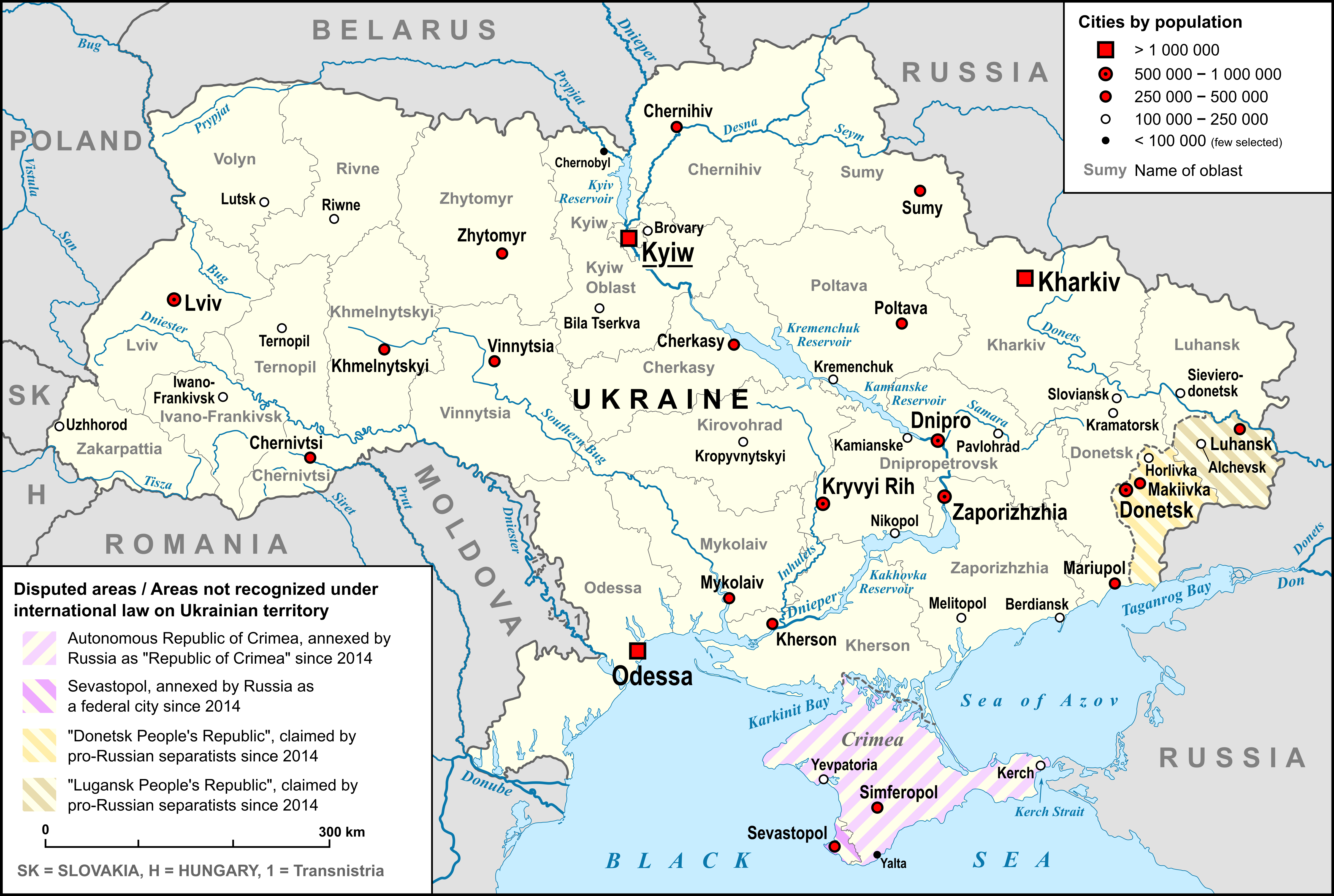
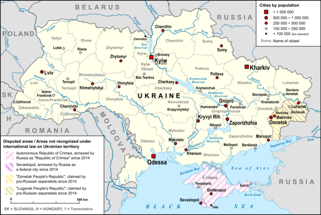
English: Map of Ukraine, with Oblasts, largest cities, rivers and neighboring countries, as well as the disputed areas on the territory of Ukraine, "Republic of Crimea", "Luhansk People's Republic" and "Donetsk People's Republic" |
| កាលបរិច្ឆេទ | |
| ប្រភព |
own work, used: |
| អ្នកនិពន្ធ | Lencer |
| ទំរង់ផ្សេងទៀត |
 |

|
This map has been made or improved in the German Kartenwerkstatt (Map Lab). You can propose maps to improve as well.
|
ការដាក់អាជ្ញាប័ណ្ណ
I, the copyright holder of this work, hereby publish it under the following license:
ឯកសារនេះជាប់អាជ្ញាបណ្ឌCreative Commons Attribution-Share Alike 3.0 Unported។
- អ្នកមានសិទ្ធិ៖
- ចែកចាយ – ថតចំលងនិងចែកចាយស្នាដៃនេះ
- កែច្នៃ – កែច្នៃយកទៅប្រើ
- ក្រោមលក្ខខណ្ឌដូចតទៅនេះ៖
- ភាពជាម្ចាស់កម្មសិទ្ធ – You must give appropriate credit, provide a link to the license, and indicate if changes were made. You may do so in any reasonable manner, but not in any way that suggests the licensor endorses you or your use.
- share alike – If you remix, transform, or build upon the material, you must distribute your contributions under the same or compatible license as the original.
ប្រវត្តិឯកសារ
ចុចលើម៉ោងនិងកាលបរិច្ឆេទដើម្បីមើលឯកសារដែលបានផ្ទុកឡើងនៅពេលនោះ។
| ម៉ោងនិងកាលបរិច្ឆេទ | កូនរូបភាព | វិមាត្រ | អ្នកប្រើប្រាស់ | យោបល់ | |
|---|---|---|---|---|---|
| បច្ចុប្បន្ន | ម៉ោង១២:៣៤ ថ្ងៃពុធ ទី០៩ ខែមីនា ឆ្នាំ២០២២ | | ៤៨៤៤ × ៣២៥៥ (២.៧២មេកាបៃ) | Lencer | corr specification |
| ម៉ោង១១:២៧ ថ្ងៃអាទិត្យ ទី០៦ ខែមីនា ឆ្នាំ២០២២ |  | ៤៨៤៤ × ៣២៥៥ (២.៧១មេកាបៃ) | Lencer | + hatching | |
| ម៉ោង២០:១៧ ថ្ងៃព្រហស្បតិ៍ ទី០៣ ខែមីនា ឆ្នាំ២០២២ |  | ៤៨៤៤ × ៣២៥៥ (២.៦៧មេកាបៃ) | Lencer | == {{int:filedesc}} == {{Information |Description= {{en|Map of Ukraine, with Oblasts, largest cities, rivers and neighboring countries, as well as the disputed areas on the territory of Ukraine, "Republic of Crimea", "Luhansk People's Republic" and "Donetsk People's Republic"}} |Source=own work, used: * Ukraine_adm_location_map.svg by User:NordNordWest * Ukraine_2022-02-21.svg by User:NordNordWest... |
បម្រើបម្រាស់ឯកសារ
ទំព័រ ខាងក្រោមប្រើប្រាស់ឯកសារនេះ ៖
បម្រើបម្រាស់ឯកសារជាសាកល
វីគីដទៃទៀតដូចខាងក្រោមនេះប្រើប្រាស់ឯកសារនេះ៖
- ការប្រើប្រាស់នៅក្នុង de.wikipedia.org
- ការប្រើប្រាស់នៅក្នុង en.wikipedia.org
- ការប្រើប្រាស់នៅក្នុង fi.wikipedia.org
- ការប្រើប្រាស់នៅក្នុង fr.wikipedia.org
- ការប្រើប្រាស់នៅក្នុង hy.wikipedia.org
- ការប្រើប្រាស់នៅក្នុង id.wikipedia.org
- ការប្រើប្រាស់នៅក្នុង ja.wikipedia.org
- ការប្រើប្រាស់នៅក្នុង ka.wikipedia.org
- ការប្រើប្រាស់នៅក្នុង kk.wikipedia.org
- ការប្រើប្រាស់នៅក្នុង ko.wikipedia.org
- ការប្រើប្រាស់នៅក្នុង ku.wikipedia.org
- ការប្រើប្រាស់នៅក្នុង simple.wikipedia.org
- ការប្រើប្រាស់នៅក្នុង sk.wikipedia.org
- ការប្រើប្រាស់នៅក្នុង sl.wikipedia.org
- ការប្រើប្រាស់នៅក្នុង ta.wikipedia.org
- ការប្រើប្រាស់នៅក្នុង tg.wikipedia.org
- ការប្រើប្រាស់នៅក្នុង th.wikipedia.org
- ការប្រើប្រាស់នៅក្នុង tr.wikipedia.org
- ការប្រើប្រាស់នៅក្នុង uk.wikipedia.org
- ការប្រើប្រាស់នៅក្នុង vi.wikipedia.org
- ការប្រើប្រាស់នៅក្នុង vls.wikipedia.org
- ការប្រើប្រាស់នៅក្នុង zh.wikipedia.org