
ឯកសារ:Red Sea topographic map-en.jpg

ទំហំរបស់ការមើលមុននេះ: ៣៦៧ × ៦០០ ភីកសែ។ ភាពម៉ត់ផ្សេងទៀត៖ ១៤៧ × ២៤០ ភីកសែ | ២៩៣ × ៤៨០ ភីកសែ | ៤៧០ × ៧៦៨ ភីកសែ | ៦២៦ × ១០២៤ ភីកសែ | ១៦៥៥ × ២៧០៥ ភីកសែ។
រូបភាពដើម (១៦៥៥ × ២៧០៥ ភីកសែល ទំហំឯកសារ៖ ១.៦៣មេកាបៃ ប្រភេទ MIME៖ image/jpeg)
ចំណារពន្យល់
| ទីតាំងម៉ាស៊ីនថត | | រូបភាពនេះនិងរូបភាពផ្សេងទៀតនៅឯទីតាំងរបស់វាលើ: OpenStreetMap |
|---|
| ការពិពណ៌នា |
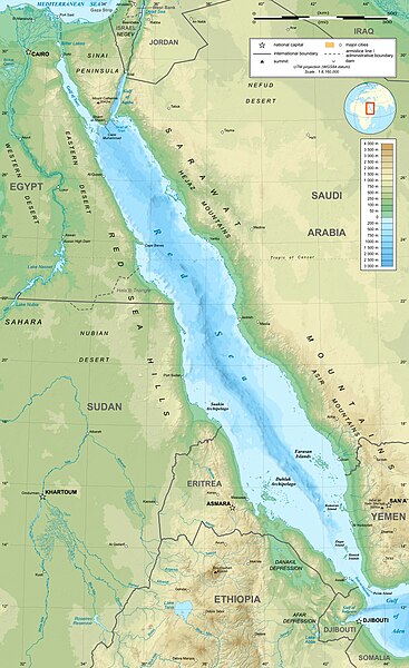
English: Topographic map in English of the Red Sea, UTM projection (WGS84 datum).
Note : for translation purpose, use the SVG version. Français : Carte topographique en anglais de la Mer Rouge, projection UTM (WGS84 datum).
|
||
| កាលបរិច្ឆេទ | |||
| ប្រភព | Own work (see complete description on Image:Red_Sea_topographic_map-en.svg) | ||
| អ្នកនិពន្ធ | Eric Gaba (Sting - fr:Sting) | ||
| ការអនុញ្ញាត (ប្រើឯកសារនេះឡើងវិញ) |
|
||
| ទំរង់ផ្សេងទៀត |
[]
|


ការដាក់អាជ្ញាប័ណ្ណ
I, the copyright holder of this work, hereby publish it under the following licenses:

|
រូបភាពនៃទំព័រនេះជាកម្មសិទ្ធិរបស់GNU Free Documentation License។ Version 1.2 ឬក៏ខ្ពស់ជាងនេះត្រូវបានឧបត្ថមគាំទ្រដោយ មូលនិធិសូហ្វវែរដោយឥតគិតថ្លៃ (Free Software Foundation) ដែលមិនមានផ្នែកណាមួយរបស់ប្រភពដើមរួមទាំងអក្សរនៅលើគំរបមុខនិងខ្នង ត្រូវបានផ្លាស់ប្តូរទេ។ ចំពោះផ្នែកដែលមិនអាចផ្លាស់ប្តូរបាន សូមមើលGNU Free Documentation License។ |
This file is licensed under the Creative Commons Attribution-Share Alike 4.0 International, 3.0 Unported, 2.5 Generic, 2.0 Generic and 1.0 Generic license.
- អ្នកមានសិទ្ធិ៖
- ចែកចាយ – ថតចំលងនិងចែកចាយស្នាដៃនេះ
- កែច្នៃ – កែច្នៃយកទៅប្រើ
- ក្រោមលក្ខខណ្ឌដូចតទៅនេះ៖
- ភាពជាម្ចាស់កម្មសិទ្ធ – You must give appropriate credit, provide a link to the license, and indicate if changes were made. You may do so in any reasonable manner, but not in any way that suggests the licensor endorses you or your use.
- share alike – If you remix, transform, or build upon the material, you must distribute your contributions under the same or compatible license as the original.
You may select the license of your choice.
ប្រវត្តិឯកសារ
ចុចលើម៉ោងនិងកាលបរិច្ឆេទដើម្បីមើលឯកសារដែលបានផ្ទុកឡើងនៅពេលនោះ។
| ម៉ោងនិងកាលបរិច្ឆេទ | កូនរូបភាព | វិមាត្រ | អ្នកប្រើប្រាស់ | យោបល់ | |
|---|---|---|---|---|---|
| បច្ចុប្បន្ន | ម៉ោង១៥:៤០ ថ្ងៃសុក្រ ទី២៩ ខែធ្នូ ឆ្នាំ២០២៣ | | ១៦៥៥ × ២៧០៥ (១.៦៣មេកាបៃ) | Sting | Without frame |
| ម៉ោង១៣:៣៧ ថ្ងៃច័ន្ទ ទី១៩ ខែកក្កដា ឆ្នាំ២០១០ |  | ១៦៥៥ × ២៧០៥ (១.៦៨មេកាបៃ) | Sting | Color profile | |
| ម៉ោង០៤:៤៧ ថ្ងៃអង្គារ ទី០២ ខែកញ្ញា ឆ្នាំ២០០៨ |  | ១៦៥៥ × ២៧០៥ (១.៦មេកាបៃ) | Sting | New standard colors ; bathymetry from ETOPO1 ; etc. | |
| ម៉ោង១៩:៣៥ ថ្ងៃព្រហស្បតិ៍ ទី០៣ ខែមេសា ឆ្នាំ២០០៨ |  | ១៦៥៥ × ២៧០៥ (១.៦៧មេកាបៃ) | Sting | Additional corrections | |
| ម៉ោង១៣:០៩ ថ្ងៃព្រហស្បតិ៍ ទី០៣ ខែមេសា ឆ្នាំ២០០៨ |  | ១៦៥៥ × ២៧០៥ (១.៧១មេកាបៃ) | Sting | Some names corrections ; some improvements | |
| ម៉ោង១១:២៦ ថ្ងៃព្រហស្បតិ៍ ទី០៣ ខែមេសា ឆ្នាំ២០០៨ |  | ១៦៥៥ × ២៧០៥ (១.៦៧មេកាបៃ) | Sting | Little correction | |
| ម៉ោង២២:៣២ ថ្ងៃពុធ ទី០២ ខែមេសា ឆ្នាំ២០០៨ |  | ១៦៥៥ × ២៧០៥ (១.៧មេកាបៃ) | Sting | {{Location|21|00|00|N|38|00|00|E|scale:10000000}} <br/> {{Information |Description={{en|Topographic map in English of the red Sea<br/>''Note :'' for translation purpose, use the SVG version.}} {{fr |
បម្រើបម្រាស់ឯកសារ
ទំព័រ ខាងក្រោមប្រើប្រាស់ឯកសារនេះ ៖
បម្រើបម្រាស់ឯកសារជាសាកល
វីគីដទៃទៀតដូចខាងក្រោមនេះប្រើប្រាស់ឯកសារនេះ៖
- ការប្រើប្រាស់នៅក្នុង ami.wikipedia.org
- ការប្រើប្រាស់នៅក្នុង am.wikipedia.org
- ការប្រើប្រាស់នៅក្នុង ban.wikipedia.org
- ការប្រើប្រាស់នៅក្នុង bg.wikipedia.org
- ការប្រើប្រាស់នៅក្នុង bh.wikipedia.org
- ការប្រើប្រាស់នៅក្នុង bn.wikipedia.org
- ការប្រើប្រាស់នៅក្នុង ca.wikipedia.org
- ការប្រើប្រាស់នៅក្នុង ckb.wikipedia.org
- ការប្រើប្រាស់នៅក្នុង en.wikipedia.org
- ការប្រើប្រាស់នៅក្នុង eu.wikipedia.org
- ការប្រើប្រាស់នៅក្នុង fa.wikipedia.org
- ការប្រើប្រាស់នៅក្នុង fa.wikivoyage.org
- ការប្រើប្រាស់នៅក្នុង fy.wikipedia.org
- ការប្រើប្រាស់នៅក្នុង gu.wikipedia.org
- ការប្រើប្រាស់នៅក្នុង hak.wikipedia.org
- ការប្រើប្រាស់នៅក្នុង he.wikipedia.org
- ការប្រើប្រាស់នៅក្នុង he.wiktionary.org
- ការប្រើប្រាស់នៅក្នុង hi.wikipedia.org
- ការប្រើប្រាស់នៅក្នុង hr.wikipedia.org
- ការប្រើប្រាស់នៅក្នុង ilo.wikipedia.org
- ការប្រើប្រាស់នៅក្នុង incubator.wikimedia.org
- ការប្រើប្រាស់នៅក្នុង ja.wikipedia.org
- ការប្រើប្រាស់នៅក្នុង ja.wikibooks.org
- ការប្រើប្រាស់នៅក្នុង ka.wikipedia.org
- ការប្រើប្រាស់នៅក្នុង kcg.wikipedia.org
- ការប្រើប្រាស់នៅក្នុង kn.wikipedia.org
- ការប្រើប្រាស់នៅក្នុង ko.wikipedia.org
- ការប្រើប្រាស់នៅក្នុង lfn.wikipedia.org
- ការប្រើប្រាស់នៅក្នុង lv.wikipedia.org
- ការប្រើប្រាស់នៅក្នុង mai.wikipedia.org
- ការប្រើប្រាស់នៅក្នុង ml.wikipedia.org
- ការប្រើប្រាស់នៅក្នុង ms.wikipedia.org
- ការប្រើប្រាស់នៅក្នុង my.wikipedia.org
- ការប្រើប្រាស់នៅក្នុង ne.wikipedia.org
- ការប្រើប្រាស់នៅក្នុង no.wikipedia.org
View more global usage of this file.