
ឯកសារ:Serbia (orthographic projection).svg

Size of this PNG preview of this SVG file: ៦០០ × ៦០០ ភីកសែ. ភាពម៉ត់ផ្សេងទៀត៖ ២៤០ × ២៤០ ភីកសែ | ៤៨០ × ៤៨០ ភីកសែ | ៧៦៨ × ៧៦៨ ភីកសែ | ១០២៤ × ១០២៤ ភីកសែ | ២០៤៨ × ២០៤៨ ភីកសែ។
រូបភាពដើម (ឯកសារប្រភេទSVG ២០៤៨ × ២០៤៨ ភីកសែល ទំហំឯកសារ៖ ១.៤៥មេកាបៃ)
ចំណារពន្យល់
| ការពិពណ៌នា |
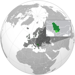
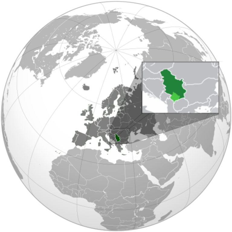
English: Serbia orthographic projection |
||
| កាលបរិច្ឆេទ | |||
| ប្រភព |
ការងារផ្ទាល់របស់អ្នកផ្ទុកឡើង This vector image includes elements that have been taken or adapted from this file: This vector image includes elements that have been taken or adapted from this file: This vector image includes elements that have been taken or adapted from this file: |
||
| អ្នកនិពន្ធ | Милан Јелисавчић | ||
| ទំរង់ផ្សេងទៀត |
.svg)
|
||
| SVG genesis |
.svg)
.svg)
.svg)
.svg)
.svg)
.svg)
.svg)
.svg)
.svg)
.svg)
.svg)
.svg)
.svg)
.svg)
.svg)
.svg)
.svg)
.svg)
.svg)
.svg)
.svg)
.svg)
.svg)
.svg)
.svg)
.svg)
.svg)
.svg)
.svg)
.svg)
.svg)
.svg)
.svg)
.svg)
.svg)
.svg)
.svg)
.svg)
.svg)
.svg)
.svg)
.svg)
.svg)
.svg)
.svg)
.svg)
.svg)
.svg)
.svg)
.svg)
.svg)
.svg)
.svg)
.svg)
.svg)
.svg)
.svg)
.svg)
.svg)
.svg)
.svg)
.svg)
.svg)
.svg)
.svg)
.svg)
.svg)
.svg)
.svg)
.svg)
.svg)
.svg)
.svg)

.svg)

.svg)

.svg)
.svg)
.svg)
.svg)
.svg)
.svg)
.svg)


.svg)
.svg)
.svg)
.svg)
.svg)
.svg)
.svg)

.svg)
.svg)
.svg)
.svg)
.svg)
.svg)
.svg)
.svg)
.svg)
.svg)

.svg)
.svg)
.svg)
.svg)
.svg)
.svg)
.svg)
_without_national_boundaries.svg)
.svg)
.svg)
.svg)
.svg)
.svg)
.svg)

.svg)
.svg)
.png)
.svg)
.svg)
.svg)
.svg)

.svg)
.svg)
.svg)
.svg)
.svg)
.svg)
.svg)
.svg)
.svg)
.svg)
.svg)

.svg)
.svg)
.svg)
.svg)
.svg)
.svg)
.svg)
.svg)
.svg)

.svg)
.svg)

.svg)
.svg)
.svg)
.svg)
.svg)
.svg)
.svg)
.svg)
.svg)
.svg)
.svg)
.svg)
.svg)
.svg)
.svg)
.svg)
.svg)
.svg)
.svg)
.svg)
.svg)
.svg)
.svg)
.svg)
.svg)
.svg)
.svg)
_-_Crimea_disputed.svg)
.svg)
.svg)
.svg)
.svg)
.svg)
.svg)
.svg)
.svg)
.svg)
.svg)
.svg)
_political.svg)
.svg)
.svg)
.svg)
.svg)
_-_Crimea_disputed_-_no_borders.svg)
.svg)
.svg)
.svg)
.svg)
.svg)
.svg)
.svg)
.svg)
.svg)
.svg)
.svg)

.svg)
.svg)
.svg)

.png)
.svg)
.svg)
.svg)
.svg)
.svg)
.svg)
.svg)
.svg)
.svg)
.svg)
.svg)
.svg)
.svg)
.svg)
.svg)
.svg)
.svg)
.svg)
.svg)
.svg)
.svg)
.svg)
.svg)
.svg)
.svg)
.svg)
.svg)
.svg)
.svg)
.svg)
.svg)
.svg)
.svg)
.svg)
.png)
.svg)
.svg)
.svg)
_(orthographic_projection).png)

.svg)
.svg)
.svg)
ការដាក់អាជ្ញាប័ណ្ណ
I, the copyright holder of this work, hereby publish it under the following license:
ឯកសារនេះជាប់អាជ្ញាបណ្ឌCreative Commons Attribution-Share Alike 3.0 Unported។
- អ្នកមានសិទ្ធិ៖
- ចែកចាយ – ថតចំលងនិងចែកចាយស្នាដៃនេះ
- កែច្នៃ – កែច្នៃយកទៅប្រើ
- ក្រោមលក្ខខណ្ឌដូចតទៅនេះ៖
- ភាពជាម្ចាស់កម្មសិទ្ធ – You must give appropriate credit, provide a link to the license, and indicate if changes were made. You may do so in any reasonable manner, but not in any way that suggests the licensor endorses you or your use.
- share alike – If you remix, transform, or build upon the material, you must distribute your contributions under the same or compatible license as the original.
ប្រវត្តិឯកសារ
ចុចលើម៉ោងនិងកាលបរិច្ឆេទដើម្បីមើលឯកសារដែលបានផ្ទុកឡើងនៅពេលនោះ។
.svg&dir=prev)
.svg&offset=20120121141735)
.svg&offset=&limit=20)
.svg&offset=&limit=50)
.svg&offset=&limit=100)
.svg&offset=&limit=250)
.svg&offset=&limit=500)
| ម៉ោងនិងកាលបរិច្ឆេទ | កូនរូបភាព | វិមាត្រ | អ្នកប្រើប្រាស់ | យោបល់ | |
|---|---|---|---|---|---|
| បច្ចុប្បន្ន | ម៉ោង១៨:៣៤ ថ្ងៃអង្គារ ទី២៧ ខែធ្នូ ឆ្នាំ២០២២ | | ២០៤៨ × ២០៤៨ (១.៤៥មេកាបៃ) | Iktsokh | More correct visualization of the dividing line on the territory of the Caucasus Range |
| ម៉ោង០៦:៤៧ ថ្ងៃព្រហស្បតិ៍ ទី២៤ ខែកុម្ភៈ ឆ្នាំ២០២២ |  | ៥៤១ × ៥៤១ (២០៥គីឡូបៃ) | Ahmet Q. | Reverted to version as of 18:50, 15 December 2021 (UTC) Rv POV-pushing | |
| ម៉ោង១៨:៣២ ថ្ងៃអាទិត្យ ទី២៦ ខែធ្នូ ឆ្នាំ២០២១ |  | ៥៤១ × ៥៤១ (៣៣៨គីឡូបៃ) | Vacant0 | Reverted to version as of 18:33, 4 June 2021 (UTC) | |
| ម៉ោង១៨:៥០ ថ្ងៃពុធ ទី១៥ ខែធ្នូ ឆ្នាំ២០២១ |  | ៥៤១ × ៥៤១ (២០៥គីឡូបៃ) | موسى | Reverted to version as of 23:32, 30 June 2020 (UTC) - саботаж; зеленый цвет в Африке | |
| ម៉ោង១៨:៣៣ ថ្ងៃសុក្រ ទី០៤ ខែមិថុនា ឆ្នាំ២០២១ |  | ៥៤១ × ៥៤១ (៣៣៨គីឡូបៃ) | Vacant0 | Reverted to version as of 15:49, 29 December 2019 (UTC) | |
| ម៉ោង២៣:៣២ ថ្ងៃអង្គារ ទី៣០ ខែមិថុនា ឆ្នាំ២០២០ |  | ៥៤១ × ៥៤១ (២០៥គីឡូបៃ) | Yeetstuff | Fixed inaccuracies (EU as whole country, French Guiana colored in, Eritrea and South Sudan not shown, Yemen split) | |
| ម៉ោង១៥:៤៩ ថ្ងៃអាទិត្យ ទី២៩ ខែធ្នូ ឆ្នាំ២០១៩ |  | ៥៤១ × ៥៤១ (៣៣៨គីឡូបៃ) | Goran tek-en | Added border for South Sudan as requested by Maphobbyist | |
| ម៉ោង០០:៣៧ ថ្ងៃអាទិត្យ ទី២២ ខែមករា ឆ្នាំ២០១២ |  | ៥៤១ × ៥៤១ (៦៥៤គីឡូបៃ) | Zenfiric | minor corrections | |
| ម៉ោង១៤:៤៤ ថ្ងៃសៅរ៍ ទី២១ ខែមករា ឆ្នាំ២០១២ |  | ៥៤១ × ៥៤១ (៦៥១គីឡូបៃ) | Zenfiric | minor correction | |
| ម៉ោង១៤:១៧ ថ្ងៃសៅរ៍ ទី២១ ខែមករា ឆ្នាំ២០១២ |  | ៥៤១ × ៥៤១ (៦៥១គីឡូបៃ) | Zenfiric | Projection with inset |
បម្រើបម្រាស់ឯកសារ
ទំព័រ ខាងក្រោមប្រើប្រាស់ឯកសារនេះ ៖
បម្រើបម្រាស់ឯកសារជាសាកល
វីគីដទៃទៀតដូចខាងក្រោមនេះប្រើប្រាស់ឯកសារនេះ៖
- ការប្រើប្រាស់នៅក្នុង af.wikipedia.org
- ការប្រើប្រាស់នៅក្នុង arc.wikipedia.org
- ការប្រើប្រាស់នៅក្នុង ar.wikipedia.org
- العلاقات العراقية الصربية
- العلاقات الأمريكية الصربية
- العلاقات الأنغولية الصربية
- العلاقات الصربية الكورية الجنوبية
- العلاقات الإريترية الصربية
- العلاقات السويسرية الصربية
- العلاقات الألمانية الصربية
- العلاقات الصربية الليختنشتانية
- العلاقات البوليفية الصربية
- العلاقات الصربية الموزمبيقية
- العلاقات الألبانية الصربية
- العلاقات البلجيكية الصربية
- العلاقات الإثيوبية الصربية
- العلاقات البيلاروسية الصربية
- العلاقات الصربية الطاجيكستانية
- العلاقات الروسية الصربية
- العلاقات الرومانية الصربية
- العلاقات الأرجنتينية الصربية
- العلاقات الصربية الغامبية
- العلاقات الصربية القبرصية
- العلاقات السيراليونية الصربية
- العلاقات الصربية النيبالية
- العلاقات الصربية الليبيرية
- العلاقات التشيكية الصربية
- العلاقات الصربية الميانمارية
- العلاقات الصربية الكندية
- العلاقات السعودية الصربية
- العلاقات الزيمبابوية الصربية
- العلاقات الإسرائيلية الصربية
- العلاقات البالاوية الصربية
- العلاقات الصربية المالية
- العلاقات الصربية النيجيرية
- العلاقات اليمنية الصربية
- العلاقات الصربية الفانواتية
- العلاقات الغابونية الصربية
- العلاقات البنمية الصربية
- العلاقات الصربية الكوبية
- العلاقات الجورجية الصربية
- العلاقات التونسية الصربية
- العلاقات الصربية الكورية الشمالية
- العلاقات الهندية الصربية
- العلاقات اليابانية الصربية
- العلاقات الإيطالية الصربية
- العلاقات الصربية الناوروية
- العلاقات الأسترالية الصربية
- العلاقات الزامبية الصربية
- العلاقات الصربية الفيجية
- العلاقات المارشالية الصربية
View more global usage of this file.
.svg)
.svg)