
ឯកសារ:Ukraine 2022-02-21.svg

រូបភាពដើម (ឯកសារប្រភេទSVG ១៥៤៦ × ១០៣៨ ភីកសែល ទំហំឯកសារ៖ ៤៥២គីឡូបៃ)
ចំណារពន្យល់
| ការពិពណ៌នា |
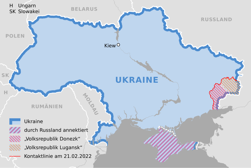
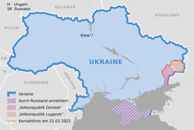
Deutsch: Karte der Ukraine, Stand 21. Februar 2022 |
||
| កាលបរិច្ឆេទ | |||
| ប្រភព |
Own work using: Ukraine adm location map.svg by NordNordWest |
||
| អ្នកនិពន្ធ | NordNordWest | ||
| SVG genesis | រូបភាពក្រាភិកវ៉ិចទ័រនេះត្រូវបានបង្កើតឡើងដោយប្រើ Adobe Illustratorដោយ NordNordWest.
|

ការដាក់អាជ្ញាប័ណ្ណ
Usage of this file with:

explanatory notes: Legally binding is only the full legalcode. For a free usage I recommend to respect the following licence conditions:
1. Provide my name as given above: NordNordWest,
2. a copy of, or the URI for, the applicable license: https://creativecommons.org/licenses/by-sa/3.0/de/legalcode,
3. the title of the work,
4. in the case of an adaptation, a credit identifying the use of the work in the adaptation.
This license and the rights granted hereunder will terminate automatically upon any breach by you of the terms of this license. Any of the above conditions can be waived if you get permission from the copyright holder. If you have questions or wish differing conditions, please contact me through nnwest or my discussion page ![]() t-online.de
t-online.de
- អ្នកមានសិទ្ធិ៖
- ចែកចាយ – ថតចំលងនិងចែកចាយស្នាដៃនេះ
- កែច្នៃ – កែច្នៃយកទៅប្រើ
- ក្រោមលក្ខខណ្ឌដូចតទៅនេះ៖
- ភាពជាម្ចាស់កម្មសិទ្ធ – You must give appropriate credit, provide a link to the license, and indicate if changes were made. You may do so in any reasonable manner, but not in any way that suggests the licensor endorses you or your use.
- share alike – If you remix, transform, or build upon the material, you must distribute your contributions under the same or compatible license as the original.

ប្រវត្តិឯកសារ
ចុចលើម៉ោងនិងកាលបរិច្ឆេទដើម្បីមើលឯកសារដែលបានផ្ទុកឡើងនៅពេលនោះ។
| ម៉ោងនិងកាលបរិច្ឆេទ | កូនរូបភាព | វិមាត្រ | អ្នកប្រើប្រាស់ | យោបល់ | |
|---|---|---|---|---|---|
| បច្ចុប្បន្ន | ម៉ោង១៥:៣៤ ថ្ងៃអាទិត្យ ទី២៧ ខែកុម្ភៈ ឆ្នាំ២០២២ | | ១៥៤៦ × ១០៣៨ (៤៥២គីឡូបៃ) | NordNordWest | Reverted to version as of 14:40, 25 February 2022 (UTC); nein danke |
| ម៉ោង២០:៣១ ថ្ងៃសៅរ៍ ទី២៦ ខែកុម្ភៈ ឆ្នាំ២០២២ |  | ១៥៤៦ × ១០៣៨ (៤៩២គីឡូបៃ) | Kematen | Donezk weiter westlich | |
| ម៉ោង១៩:៥១ ថ្ងៃសុក្រ ទី២៥ ខែកុម្ភៈ ឆ្នាំ២០២២ |  | ១៥៤៦ × ១០៣៨ (៤៩២គីឡូបៃ) | Kematen | übersichtlicher | |
| ម៉ោង១៤:៤០ ថ្ងៃសុក្រ ទី២៥ ខែកុម្ភៈ ឆ្នាំ២០២២ |  | ១៥៤៦ × ១០៣៨ (៤៥២គីឡូបៃ) | NordNordWest | c | |
| ម៉ោង១៤:៣៨ ថ្ងៃសុក្រ ទី២៥ ខែកុម្ភៈ ឆ្នាំ២០២២ |  | ១៥៤៦ × ១០៣៨ (៤៥០គីឡូបៃ) | NordNordWest | c | |
| ម៉ោង២១:៤០ ថ្ងៃព្រហស្បតិ៍ ទី២៤ ខែកុម្ភៈ ឆ្នាំ២០២២ |  | ១៥៤៦ × ១០៣៨ (៤៤២គីឡូបៃ) | NordNordWest | == {{int:filedesc}} == {{Information |description= {{de|1=Karte der Ukraine, Stand 21. Februar 2022}} |source={{Own using|Ukraine adm location map.svg|by=NordNordWest}} * https://www.osce.org/files/b/c/map_settlements--2022-02-20.jpg?itok=82567= |date={{Date|2022|02|24}} |author={{U|NordNordWest}} |permission= |other_versions= }} {{Kartenwerkstatt}} == {{int:license-header}} == {{User:NordNordWest/LicenceMap}} Category:Maps of the Russo-Ukrainian war Category:SVG maps of Ukraine [[... |
បម្រើបម្រាស់ឯកសារ
គ្មានទំព័រណាមួយដែលប្រើប្រាស់ឯកសារនេះទេ។
បម្រើបម្រាស់ឯកសារជាសាកល
វីគីដទៃទៀតដូចខាងក្រោមនេះប្រើប្រាស់ឯកសារនេះ៖
- ការប្រើប្រាស់នៅក្នុង als.wikipedia.org
- ការប្រើប្រាស់នៅក្នុង de.wikipedia.org
- ការប្រើប្រាស់នៅក្នុង en.wikipedia.org