
ឯកសារ:West Bank and Gaza Strip location map.svg

Size of this PNG preview of this SVG file: ៥២០ × ៥៩៩ ភីកសែ. ភាពម៉ត់ផ្សេងទៀត៖ ២០៨ × ២៤០ ភីកសែ | ៤១៧ × ៤៨០ ភីកសែ | ៦៦៧ × ៧៦៨ ភីកសែ | ៨៨៩ × ១០២៤ ភីកសែ | ១៧៧៨ × ២០៤៨ ភីកសែ | ៦៣៩ × ៧៣៦ ភីកសែ។
រូបភាពដើម (ឯកសារប្រភេទSVG ៦៣៩ × ៧៣៦ ភីកសែល ទំហំឯកសារ៖ ៩៨គីឡូបៃ)

|
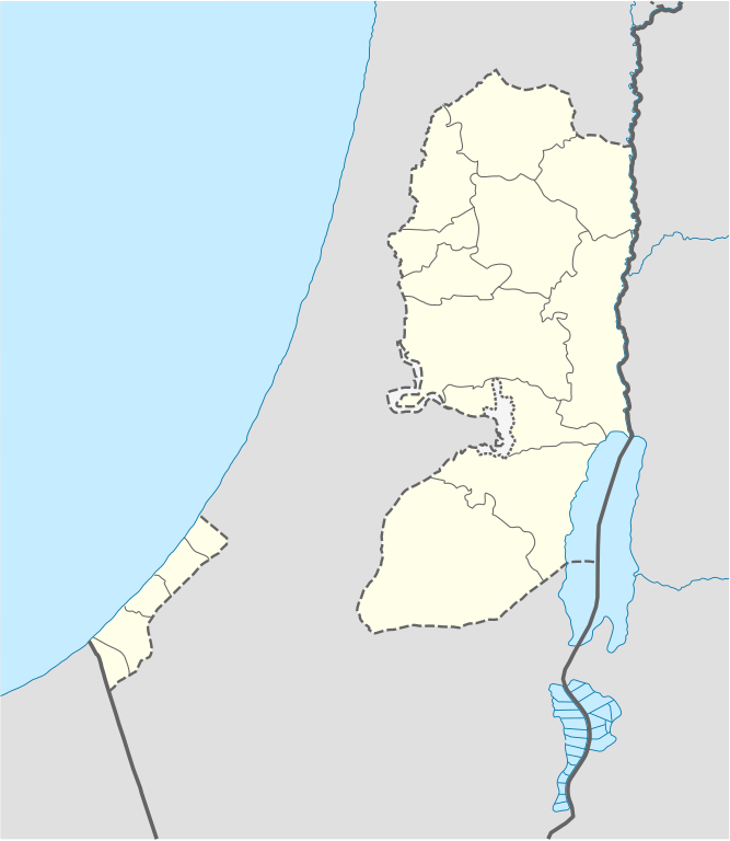
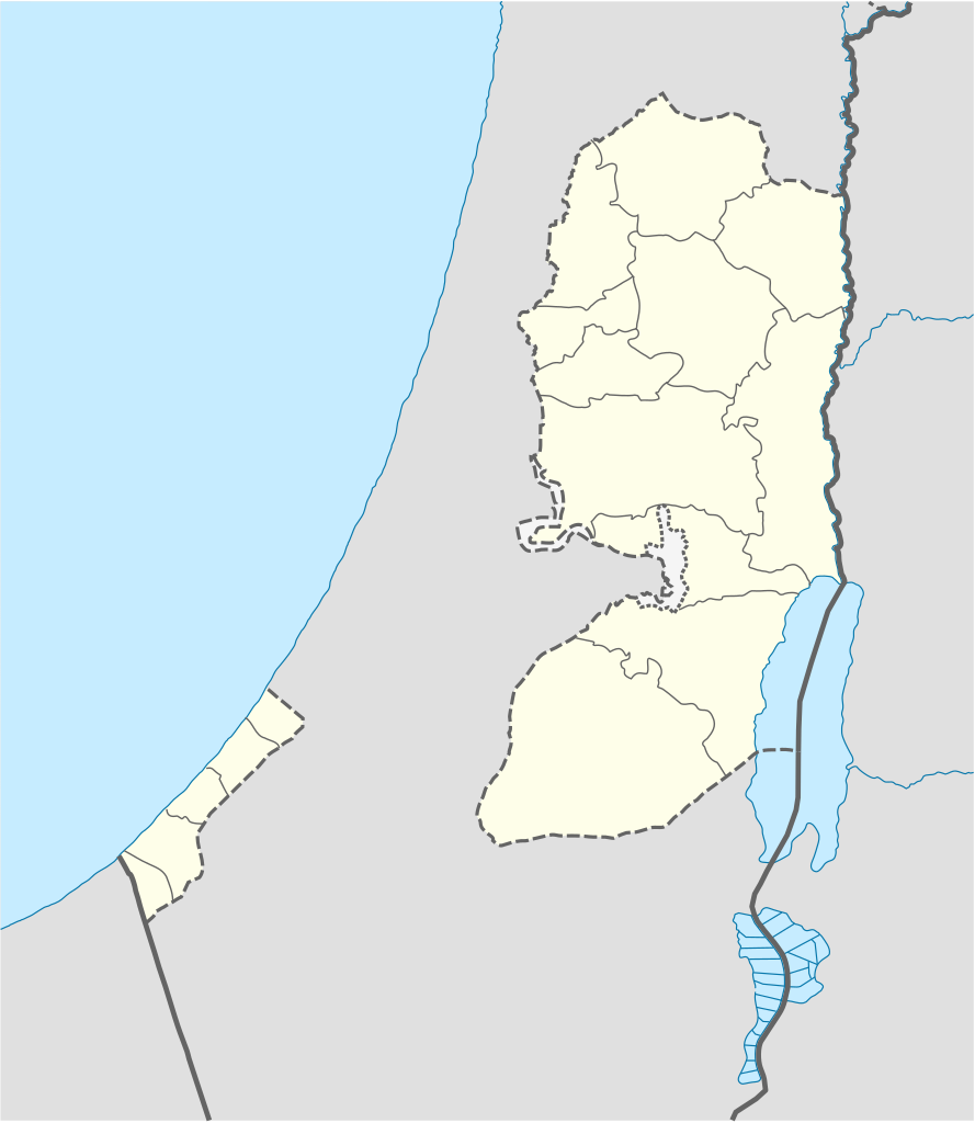
The boundaries on this map show the de facto situation. This is just one of several different views on the subject (see COM:NPOV). |
ចំណារពន្យល់
| ការពិពណ៌នា |
Deutsch: Positionskarte der Palästinensische Autonomiegebiete bzw. von Westjordanland und Gazastreifen
Quadratische Plattkarte, N-S-Streckung 115 %. Geographische Begrenzung der Karte:
Equirectangular projection, N/S stretching 115%. Geographic limits of the map:
|
||
| កាលបរិច្ឆេទ | |||
| ប្រភព |
Own work using:
|
||
| អ្នកនិពន្ធ | NordNordWest | ||
| ទំរង់ផ្សេងទៀត |
Derivative works of this file: |
||
| SVG genesis | រូបភាពក្រាភិកវ៉ិចទ័រនេះត្រូវបានបង្កើតឡើងដោយប្រើ Adobe Illustrator, and with Inkscape.
|

ការដាក់អាជ្ញាប័ណ្ណ
I, the copyright holder of this work, hereby publish it under the following licenses:

|
រូបភាពនៃទំព័រនេះជាកម្មសិទ្ធិរបស់GNU Free Documentation License។ Version 1.2 ឬក៏ខ្ពស់ជាងនេះត្រូវបានឧបត្ថមគាំទ្រដោយ មូលនិធិសូហ្វវែរដោយឥតគិតថ្លៃ (Free Software Foundation) ដែលមិនមានផ្នែកណាមួយរបស់ប្រភពដើមរួមទាំងអក្សរនៅលើគំរបមុខនិងខ្នង ត្រូវបានផ្លាស់ប្តូរទេ។ ចំពោះផ្នែកដែលមិនអាចផ្លាស់ប្តូរបាន សូមមើលGNU Free Documentation License។ |
ឯកសារនេះជាប់អាជ្ញាបណ្ឌCreative Commons Attribution-Share Alike 3.0 Unported។
- អ្នកមានសិទ្ធិ៖
- ចែកចាយ – ថតចំលងនិងចែកចាយស្នាដៃនេះ
- កែច្នៃ – កែច្នៃយកទៅប្រើ
- ក្រោមលក្ខខណ្ឌដូចតទៅនេះ៖
- ភាពជាម្ចាស់កម្មសិទ្ធ – You must give appropriate credit, provide a link to the license, and indicate if changes were made. You may do so in any reasonable manner, but not in any way that suggests the licensor endorses you or your use.
- share alike – If you remix, transform, or build upon the material, you must distribute your contributions under the same or compatible license as the original.
You may select the license of your choice.
ប្រវត្តិឯកសារ
ចុចលើម៉ោងនិងកាលបរិច្ឆេទដើម្បីមើលឯកសារដែលបានផ្ទុកឡើងនៅពេលនោះ។
| ម៉ោងនិងកាលបរិច្ឆេទ | កូនរូបភាព | វិមាត្រ | អ្នកប្រើប្រាស់ | យោបល់ | |
|---|---|---|---|---|---|
| បច្ចុប្បន្ន | ម៉ោង១១:៣៥ ថ្ងៃអង្គារ ទី២៨ ខែមេសា ឆ្នាំ២០០៩ | | ៦៣៩ × ៧៣៦ (៩៨គីឡូបៃ) | NordNordWest | area of West Bank back to correct position |
| ម៉ោង០២:០២ ថ្ងៃអង្គារ ទី២៨ ខែមេសា ឆ្នាំ២០០៩ |  | ៦៣៩ × ៧៣៦ (១០៩គីឡូបៃ) | Fjmustak | 0.85px solid governorate lines (consistent with Israel, Jordan, Lebanon, etc...) | |
| ម៉ោង១៨:៥៨ ថ្ងៃពុធ ទី២២ ខែមេសា ឆ្នាំ២០០៩ |  | ៦៣៩ × ៧៣៦ (៩៨គីឡូបៃ) | NordNordWest | corr | |
| ម៉ោង០២:០២ ថ្ងៃសុក្រ ទី១៧ ខែមេសា ឆ្នាំ២០០៩ |  | ៦៣៨ × ៧៣៤ (១១៩គីឡូបៃ) | Fjmustak | Added governorate boundaries | |
| ម៉ោង១៨:៣០ ថ្ងៃសៅរ៍ ទី២៩ ខែវិច្ឆិកា ឆ្នាំ២០០៨ |  | ៦៣៨ × ៧៣៤ (១០៣គីឡូបៃ) | NordNordWest | ||
| ម៉ោង២០:០៥ ថ្ងៃពុធ ទី១៩ ខែវិច្ឆិកា ឆ្នាំ២០០៨ |  | ៦៣៨ × ៧៣៤ (១១៨គីឡូបៃ) | NordNordWest | {{Information |Description= {{de|Positionskarte der Palästinensischen Autonomiegebiete bzw. von Westjordanland und Gazastreifen}} Quadratische Plattkarte, N-S-Streckung 115 %. Geographische Begrenzung der Karte: |
បម្រើបម្រាស់ឯកសារ
ទំព័រ ខាងក្រោមប្រើប្រាស់ឯកសារនេះ ៖
បម្រើបម្រាស់ឯកសារជាសាកល
វីគីដទៃទៀតដូចខាងក្រោមនេះប្រើប្រាស់ឯកសារនេះ៖
- ការប្រើប្រាស់នៅក្នុង af.wikipedia.org
- ការប្រើប្រាស់នៅក្នុង als.wikipedia.org
- ការប្រើប្រាស់នៅក្នុង an.wikipedia.org
- ការប្រើប្រាស់នៅក្នុង ar.wikipedia.org
- ការប្រើប្រាស់នៅក្នុង az.wikipedia.org
- ការប្រើប្រាស់នៅក្នុង ba.wikipedia.org
- ការប្រើប្រាស់នៅក្នុង be-tarask.wikipedia.org
- ការប្រើប្រាស់នៅក្នុង be.wikipedia.org
- ការប្រើប្រាស់នៅក្នុង bg.wikipedia.org
- ការប្រើប្រាស់នៅក្នុង bn.wikipedia.org
- ការប្រើប្រាស់នៅក្នុង ce.wikipedia.org
- ការប្រើប្រាស់នៅក្នុង ckb.wikipedia.org
- ការប្រើប្រាស់នៅក្នុង cs.wikipedia.org
View more global usage of this file.