
ឯកសារ:Argentina topo blank.jpg

ទំហំរបស់ការមើលមុននេះ: ៤៤៥ × ៥៩៩ ភីកសែ។ ភាពម៉ត់ផ្សេងទៀត៖ ១៧៨ × ២៤០ ភីកសែ | ៣៥៧ × ៤៨០ ភីកសែ | ៥៧១ × ៧៦៨ ភីកសែ | ៧៦១ × ១០២៤ ភីកសែ | ១៦០០ × ២១៥៣ ភីកសែ។
រូបភាពដើម (១៦០០ × ២១៥៣ ភីកសែល ទំហំឯកសារ៖ ៥៦៥គីឡូបៃ ប្រភេទ MIME៖ image/jpeg)
| ការពិពណ៌នា |
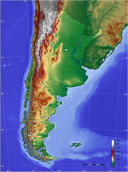
Español: Mapa de Argentina con su relieve
English: Map of Argentina with its terrain levels |
||||||||||
| កាលបរិច្ឆេទ | 9/06/2006 | ||||||||||
| ប្រភព | See below | ||||||||||
| អ្នកនិពន្ធ | Captain Blood | ||||||||||
| ការអនុញ្ញាត (ប្រើឯកសារនេះឡើងវិញ) |
|

ប្រវត្តិឯកសារ
ចុចលើម៉ោងនិងកាលបរិច្ឆេទដើម្បីមើលឯកសារដែលបានផ្ទុកឡើងនៅពេលនោះ។
| ម៉ោងនិងកាលបរិច្ឆេទ | កូនរូបភាព | វិមាត្រ | អ្នកប្រើប្រាស់ | យោបល់ | |
|---|---|---|---|---|---|
| បច្ចុប្បន្ន | ម៉ោង២១:៤៥ ថ្ងៃពុធ ទី១៣ ខែឧសភា ឆ្នាំ២០០៩ | | ១៦០០ × ២១៥៣ (៥៦៥គីឡូបៃ) | Keysanger | reverted. (Deleted yellow line in the Straits of Magellan, added the definitive end of the controversial border at the Beagle Channel and marked with a white box the (last) undefined border zone as agreed both countries.) |
| ម៉ោង០៤:១០ ថ្ងៃអង្គារ ទី០៥ ខែឧសភា ឆ្នាំ២០០៩ |  | ១៦០០ × ២១៥៣ (៨៦៧គីឡូបៃ) | Dexxter | Reverted to version as of 18:57, 9 June 2006 | |
| ម៉ោង២០:១៣ ថ្ងៃពុធ ទី០៤ ខែមិថុនា ឆ្នាំ២០០៨ |  | ១៦០០ × ២១៥៣ (៥៦៥គីឡូបៃ) | Keysanger | Argentina topo deleted yellow line in the Straits of Magellan, added the definitive end of the controversial border at the Beagle Channel and marked with a white box the (last) undefined border zone as agreed both countries. [[Category:[[Category:Topograp | |
| ម៉ោង១៨:៥៧ ថ្ងៃសុក្រ ទី០៩ ខែមិថុនា ឆ្នាំ២០០៦ |  | ១៦០០ × ២១៥៣ (៨៦៧គីឡូបៃ) | Captain Blood~commonswiki | {{Bild-GFDL-GMT}} |
បម្រើបម្រាស់ឯកសារ
គ្មានទំព័រណាមួយដែលប្រើប្រាស់ឯកសារនេះទេ។
បម្រើបម្រាស់ឯកសារជាសាកល
វីគីដទៃទៀតដូចខាងក្រោមនេះប្រើប្រាស់ឯកសារនេះ៖
- ការប្រើប្រាស់នៅក្នុង bg.wikipedia.org
- ការប្រើប្រាស់នៅក្នុង bn.wikipedia.org
- ការប្រើប្រាស់នៅក្នុង ca.wikipedia.org
- ការប្រើប្រាស់នៅក្នុង ckb.wikipedia.org
- ការប្រើប្រាស់នៅក្នុង dz.wikipedia.org
- ការប្រើប្រាស់នៅក្នុង ee.wikipedia.org
- ការប្រើប្រាស់នៅក្នុង el.wikipedia.org
- ការប្រើប្រាស់នៅក្នុង en.wikipedia.org
- ការប្រើប្រាស់នៅក្នុង eo.wikipedia.org
- ការប្រើប្រាស់នៅក្នុង es.wikipedia.org
- ការប្រើប្រាស់នៅក្នុង eu.wikipedia.org
- ការប្រើប្រាស់នៅក្នុង fa.wikipedia.org
- ការប្រើប្រាស់នៅក្នុង fi.wikipedia.org
- ការប្រើប្រាស់នៅក្នុង fr.wikipedia.org
- ការប្រើប្រាស់នៅក្នុង gcr.wikipedia.org
- ការប្រើប្រាស់នៅក្នុង hu.wikipedia.org
- ការប្រើប្រាស់នៅក្នុង hy.wikipedia.org
- ការប្រើប្រាស់នៅក្នុង incubator.wikimedia.org
- ការប្រើប្រាស់នៅក្នុង io.wikipedia.org
- ការប្រើប្រាស់នៅក្នុង it.wikipedia.org
- ការប្រើប្រាស់នៅក្នុង ja.wikipedia.org
- ការប្រើប្រាស់នៅក្នុង ka.wikipedia.org
- ការប្រើប្រាស់នៅក្នុង kbd.wikipedia.org
- ការប្រើប្រាស់នៅក្នុង ko.wikipedia.org
- ការប្រើប្រាស់នៅក្នុង ml.wikipedia.org
- ការប្រើប្រាស់នៅក្នុង ms.wikipedia.org
- ការប្រើប្រាស់នៅក្នុង mt.wikipedia.org
- ការប្រើប្រាស់នៅក្នុង pl.wikipedia.org
- ការប្រើប្រាស់នៅក្នុង pt.wikipedia.org
View more global usage of this file.