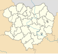
ឯកសារ:Kharkiv province location map.svg
Appearance

Size of this PNG preview of this SVG file: ៥៣៣ × ៤៨៩ ភីកសែ. ភាពម៉ត់ផ្សេងទៀត៖ ២៦២ × ២៤០ ភីកសែ | ៥២៣ × ៤៨០ ភីកសែ | ៨៣៧ × ៧៦៨ ភីកសែ | ១១១៦ × ១០២៤ ភីកសែ | ២២៣២ × ២០៤៨ ភីកសែ។
រូបភាពដើម (ឯកសារប្រភេទSVG ៥៣៣ × ៤៨៩ ភីកសែល ទំហំឯកសារ៖ ២៨១គីឡូបៃ)
ប្រវត្តិឯកសារ
ចុចលើម៉ោងនិងកាលបរិច្ឆេទដើម្បីមើលឯកសារដែលបានផ្ទុកឡើងនៅពេលនោះ។
| ម៉ោងនិងកាលបរិច្ឆេទ | កូនរូបភាព | វិមាត្រ | អ្នកប្រើប្រាស់ | យោបល់ | |
|---|---|---|---|---|---|
| បច្ចុប្បន្ន | ម៉ោង០៩:០៦ ថ្ងៃអាទិត្យ ទី២៩ ខែមិថុនា ឆ្នាំ២០១៤ |  | ៥៣៣ × ៤៨៩ (២៨១គីឡូបៃ) | קרלוס הגדול | lighter borders between provinces |
| ម៉ោង១៣:៤២ ថ្ងៃច័ន្ទ ទី១១ ខែមិថុនា ឆ្នាំ២០១២ |  | ៥៣៣ × ៤៨៩ (២៨០គីឡូបៃ) | DenysZ | {{Information |Description={{en|1=Location map of Kharkiv province, Ukraine}} {{ru|1=Позиционная карта Харьковской области, Украина}} |Source={{own}} |Author=Urutseg |Date=2010-12-05 |Permission... | |
| ម៉ោង១៣:៣៥ ថ្ងៃច័ន្ទ ទី១១ ខែមិថុនា ឆ្នាំ២០១២ |  | ៥៣៤ × ៤៨៩ (២៧៩គីឡូបៃ) | DenysZ | {{Information |Description={{en|1=Location map of Kharkiv province, Ukraine}} {{ru|1=Позиционная карта Харьковской области, Украина}} |Source={{own}} |Author=Urutseg |Date=2010-12-05 |Permission... | |
| ម៉ោង២០:៤៣ ថ្ងៃអាទិត្យ ទី០៥ ខែធ្នូ ឆ្នាំ២០១០ |  | ៥៣៤ × ៤៨៩ (២៧៨គីឡូបៃ) | Urutseg | == Summary == {{Information |Description={{en|1=Location map of Kharkiv province, Ukraine}} {{ru|1=Позиционная карта Харьковской области, Украина}} |Source={{own}} |Author=Urutseg |Date=2010-12-05 |
បម្រើបម្រាស់ឯកសារ
ទំព័រ ខាងក្រោមប្រើប្រាស់ឯកសារនេះ ៖
បម្រើបម្រាស់ឯកសារជាសាកល
វីគីដទៃទៀតដូចខាងក្រោមនេះប្រើប្រាស់ឯកសារនេះ៖
- ការប្រើប្រាស់នៅក្នុង ar.wikipedia.org
- ការប្រើប្រាស់នៅក្នុង azb.wikipedia.org
- ការប្រើប្រាស់នៅក្នុង bg.wikipedia.org
- ការប្រើប្រាស់នៅក្នុង ceb.wikipedia.org
- ការប្រើប្រាស់នៅក្នុង da.wikipedia.org
- ការប្រើប្រាស់នៅក្នុង de.wikipedia.org
- ការប្រើប្រាស់នៅក្នុង eo.wikipedia.org
- Ĉuhujivo
- Ŝablono:Situo sur mapo Ukrainio Ĥarkiva provinco
- Ĥarkiv-Pasaĵirskij (stacidomo)
- Izjum
- Merefa
- Izjum (stacidomo)
- Merefa (stacidomo)
- Ĉuhujiv (stacidomo)
- Lozova-Pasaĵirska (stacidomo)
- Lozova
- Krasnohrad (stacidomo)
- Krasnohrad
- Ĥarkiv-Balaŝovskij (stacidomo)
- Ĥarkiv-Levada (stacidomo)
- Bohoduĥiv (stacidomo)
- Bohoduĥiv
- Ljubotin (stacidomo)
- Ljubotin
- Kolomak (stacidomo)
- Ŝelestove
- Zmijiv (stacidomo)
- Zmijiv
- Kupjansk
- Vovĉansk (stacidomo)
- Vovĉansk
- Kupjansk-Vuzlovij (stacidomo)
- Kupjansk-Vuzlovij
View more global usage of this file.

