
ឯកសារ:Lismore Island.jpg
គ្មានភាពម៉ត់ខ្ពស់ជាងនេះទេ។
Lismore_Island.jpg (៦៤០ × ៤៨០ ភីកសែល ទំហំឯកសារ៖ ១២៤គីឡូបៃ ប្រភេទ MIME៖ image/jpeg)
ចំណារពន្យល់
| ការពិពណ៌នា |
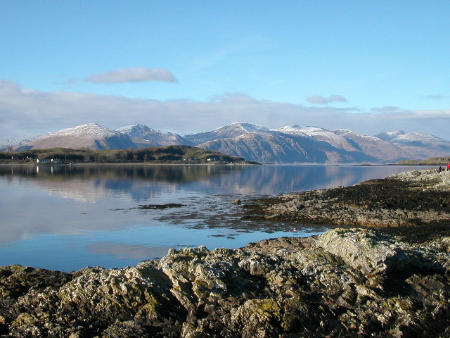
English: Lismore Island and the hills of Kingairloch beyond. The ferry runs from Port Appin on the extreme right of the picture. |
| កាលបរិច្ឆេទ | |
| ប្រភព | From geograph.org.uk |
| អ្នកនិពន្ធ | Alan Partridge |
| ការអនុញ្ញាត (ប្រើឯកសារនេះឡើងវិញ) |
Creative Commons Attribution Share-alike license 2.0 |
| ទីតាំងម៉ាស៊ីនថត | | រូបភាពនេះនិងរូបភាពផ្សេងទៀតនៅឯទីតាំងរបស់វាលើ: OpenStreetMap |
|---|
ការដាក់អាជ្ញាប័ណ្ណ

|
This image was taken from the Geograph project collection. See this photograph's page on the Geograph website for the photographer's contact details. The copyright on this image is owned by Alan Partridge and is licensed for reuse under the Creative Commons Attribution-ShareAlike 2.0 license.
|
ឯកសារនេះជាប់អាជ្ញាបណ្ឌCreative Commons Attribution-Share Alike 2.0 Generic។
ភាពជាម្ចាស់កម្មសិទ្ធ: Alan Partridge
- អ្នកមានសិទ្ធិ៖
- ចែកចាយ – ថតចំលងនិងចែកចាយស្នាដៃនេះ
- កែច្នៃ – កែច្នៃយកទៅប្រើ
- ក្រោមលក្ខខណ្ឌដូចតទៅនេះ៖
- ភាពជាម្ចាស់កម្មសិទ្ធ – You must give appropriate credit, provide a link to the license, and indicate if changes were made. You may do so in any reasonable manner, but not in any way that suggests the licensor endorses you or your use.
- share alike – If you remix, transform, or build upon the material, you must distribute your contributions under the same or compatible license as the original.
ប្រវត្តិឯកសារ
ចុចលើម៉ោងនិងកាលបរិច្ឆេទដើម្បីមើលឯកសារដែលបានផ្ទុកឡើងនៅពេលនោះ។
| ម៉ោងនិងកាលបរិច្ឆេទ | កូនរូបភាព | វិមាត្រ | អ្នកប្រើប្រាស់ | យោបល់ | |
|---|---|---|---|---|---|
| បច្ចុប្បន្ន | ម៉ោង០៨:២៦ ថ្ងៃច័ន្ទ ទី១៤ ខែមិថុនា ឆ្នាំ២០២១ | | ៦៤០ × ៤៨០ (១២៤គីឡូបៃ) | Bjh21 | Replace with visually-identical original from Geograph, which should have less generation loss |
| ម៉ោង១៣:២២ ថ្ងៃច័ន្ទ ទី២៦ ខែធ្នូ ឆ្នាំ២០០៥ |  | ៦៤០ × ៤៨០ (៩៨គីឡូបៃ) | Cactus.man | Lismore Island and the hills of Kingairloch beyond. The ferry runs from Port Appin on the extreme right of the picture. Blah. Photograph by Alan Partridge [http://www.geograph.org.uk/photo/62829] {{Cc-by-sa-2.0}} Category:Scotland [[Category:Islan |
បម្រើបម្រាស់ឯកសារ
គ្មានទំព័រណាមួយដែលប្រើប្រាស់ឯកសារនេះទេ។
បម្រើបម្រាស់ឯកសារជាសាកល
វីគីដទៃទៀតដូចខាងក្រោមនេះប្រើប្រាស់ឯកសារនេះ៖
- ការប្រើប្រាស់នៅក្នុង br.wikipedia.org
- ការប្រើប្រាស់នៅក្នុង de.wikipedia.org
- ការប្រើប្រាស់នៅក្នុង en.wikipedia.org
- ការប្រើប្រាស់នៅក្នុង fr.wikipedia.org
- ការប្រើប្រាស់នៅក្នុង ga.wikipedia.org
- ការប្រើប្រាស់នៅក្នុង gd.wikipedia.org
- ការប្រើប្រាស់នៅក្នុង he.wikipedia.org
- ការប្រើប្រាស់នៅក្នុង it.wikipedia.org
- ការប្រើប្រាស់នៅក្នុង la.wikipedia.org
- ការប្រើប្រាស់នៅក្នុង nn.wikipedia.org
- ការប្រើប្រាស់នៅក្នុង no.wikipedia.org
- ការប្រើប្រាស់នៅក្នុង pl.wikipedia.org
- ការប្រើប្រាស់នៅក្នុង uk.wikipedia.org