
ឯកសារ:Mughal Empire (orthographic projection).svg

Size of this PNG preview of this SVG file: ៥៤១ × ៥៤១ ភីកសែ. ភាពម៉ត់ផ្សេងទៀត៖ ២៤០ × ២៤០ ភីកសែ | ៤៨០ × ៤៨០ ភីកសែ | ៧៦៨ × ៧៦៨ ភីកសែ | ១០២៤ × ១០២៤ ភីកសែ | ២០៤៨ × ២០៤៨ ភីកសែ។
រូបភាពដើម (ឯកសារប្រភេទSVG ៥៤១ × ៥៤១ ភីកសែល ទំហំឯកសារ៖ ២១៧គីឡូបៃ)

.svg)
ចំណារពន្យល់
| ការពិពណ៌នា |
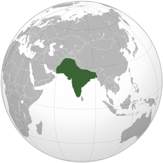
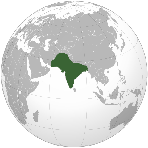
English: Location of Mughal Empire in the reign of Aurangzeb. |
| កាលបរិច្ឆេទ | |
| ប្រភព | ការងារផ្ទាល់របស់អ្នកផ្ទុកឡើង |
| អ្នកនិពន្ធ | KarnRedsun |
ការដាក់អាជ្ញាប័ណ្ណ
I, the copyright holder of this work, hereby publish it under the following licenses:
ឯកសារនេះជាប់អាជ្ញាបណ្ឌCreative Commons Attribution-Share Alike 3.0 Unported។
- អ្នកមានសិទ្ធិ៖
- ចែកចាយ – ថតចំលងនិងចែកចាយស្នាដៃនេះ
- កែច្នៃ – កែច្នៃយកទៅប្រើ
- ក្រោមលក្ខខណ្ឌដូចតទៅនេះ៖
- ភាពជាម្ចាស់កម្មសិទ្ធ – You must give appropriate credit, provide a link to the license, and indicate if changes were made. You may do so in any reasonable manner, but not in any way that suggests the licensor endorses you or your use.
- share alike – If you remix, transform, or build upon the material, you must distribute your contributions under the same or compatible license as the original.

|
រូបភាពនៃទំព័រនេះជាកម្មសិទ្ធិរបស់GNU Free Documentation License។ Version 1.2 ឬក៏ខ្ពស់ជាងនេះត្រូវបានឧបត្ថមគាំទ្រដោយ មូលនិធិសូហ្វវែរដោយឥតគិតថ្លៃ (Free Software Foundation) ដែលមិនមានផ្នែកណាមួយរបស់ប្រភពដើមរួមទាំងអក្សរនៅលើគំរបមុខនិងខ្នង ត្រូវបានផ្លាស់ប្តូរទេ។ ចំពោះផ្នែកដែលមិនអាចផ្លាស់ប្តូរបាន សូមមើលGNU Free Documentation License។ |
You may select the license of your choice.
ប្រវត្តិឯកសារ
ចុចលើម៉ោងនិងកាលបរិច្ឆេទដើម្បីមើលឯកសារដែលបានផ្ទុកឡើងនៅពេលនោះ។
| ម៉ោងនិងកាលបរិច្ឆេទ | កូនរូបភាព | វិមាត្រ | អ្នកប្រើប្រាស់ | យោបល់ | |
|---|---|---|---|---|---|
| បច្ចុប្បន្ន | ម៉ោង១៦:២៩ ថ្ងៃព្រហស្បតិ៍ ទី១៩ ខែធ្នូ ឆ្នាំ២០១៩ | | ៥៤១ × ៥៤១ (២១៧គីឡូបៃ) | Goran tek-en | Added border for South Sudan as requested by {{u|Maphobbyist}} |
| ម៉ោង០៩:១១ ថ្ងៃសៅរ៍ ទី១៧ ខែតុលា ឆ្នាំ២០០៩ |  | ៥៤១ × ៥៤១ (៥៥២គីឡូបៃ) | KarnRedsun | {{Information |Description={{en|1=Location of Mughal Empire in the reign of Aurangzeb.}} |Source={{own}} |Author=KarnRedsun |Date=2009-10-17 |Permission= |other_versions= }} Category:SVG - Orthographic projections [[Category:Maps |
បម្រើបម្រាស់ឯកសារ
គ្មានទំព័រណាមួយដែលប្រើប្រាស់ឯកសារនេះទេ។
បម្រើបម្រាស់ឯកសារជាសាកល
វីគីដទៃទៀតដូចខាងក្រោមនេះប្រើប្រាស់ឯកសារនេះ៖
- ការប្រើប្រាស់នៅក្នុង ckb.wikipedia.org
- ការប្រើប្រាស់នៅក្នុង el.wikipedia.org
- ការប្រើប្រាស់នៅក្នុង en.wikipedia.org
- ការប្រើប្រាស់នៅក្នុង es.wikipedia.org
- ការប្រើប្រាស់នៅក្នុង fr.wikipedia.org
- ការប្រើប្រាស់នៅក្នុង he.wikipedia.org
- ការប្រើប្រាស់នៅក្នុង id.wikipedia.org
- ការប្រើប្រាស់នៅក្នុង it.wikipedia.org
- ការប្រើប្រាស់នៅក្នុង it.wikivoyage.org
- ការប្រើប្រាស់នៅក្នុង ja.wikipedia.org
- ការប្រើប្រាស់នៅក្នុង jv.wikipedia.org
- ការប្រើប្រាស់នៅក្នុង ko.wikipedia.org
- ការប្រើប្រាស់នៅក្នុង ky.wikipedia.org
- ការប្រើប្រាស់នៅក្នុង mg.wikipedia.org
- ការប្រើប្រាស់នៅក្នុង sco.wikipedia.org
- ការប្រើប្រាស់នៅក្នុង tr.wikipedia.org
- ការប្រើប្រាស់នៅក្នុង vi.wikipedia.org
.svg)