
ឯកសារ:Europe-Isle of Man.svg

Size of this PNG preview of this SVG file: ៧១៣ × ៦០០ ភីកសែ. ភាពម៉ត់ផ្សេងទៀត៖ ២៨៥ × ២៤០ ភីកសែ | ៥៧១ × ៤៨០ ភីកសែ | ៩១៣ × ៧៦៨ ភីកសែ | ១២១៨ × ១០២៤ ភីកសែ | ២៤៣៥ × ២០៤៨ ភីកសែ | ២០៤៥ × ១៧២០ ភីកសែ។
រូបភាពដើម (ឯកសារប្រភេទSVG ២០៤៥ × ១៧២០ ភីកសែល ទំហំឯកសារ៖ ២.២៤មេកាបៃ)
ចំណារពន្យល់
| ការពិពណ៌នា |
English:
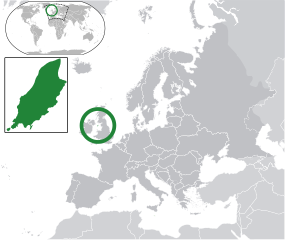
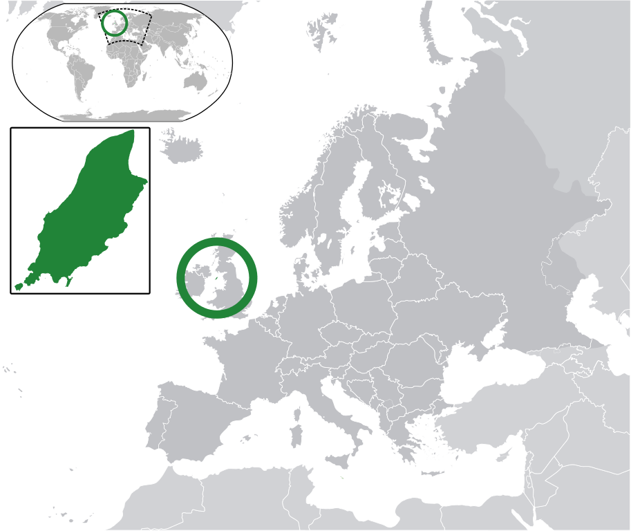
Map in English of the Isle of Man, with bounds of sheadings, towns, villages, districts and parishes. (Green) Isle of Man.
(Gray) Europe.
(Light-gray) The surrounding region.
The Full Map of the Isle of Man |
||
| កាលបរិច្ឆេទ | |||
| ប្រភព | Own work based on: IsleOfMan SheadingsAndParishes-en.svg | ||
| អ្នកនិពន្ធ | Chipmunkdavis | ||
| ការអនុញ្ញាត (ប្រើឯកសារនេះឡើងវិញ) |
ឯកសារនេះជាប់អាជ្ញាបណ្ឌCreative Commons Attribution-Share Alike 3.0 Unported។
|
||
| SVG genesis | រូបភាពក្រាភិកវ៉ិចទ័រនេះត្រូវបានបង្កើតឡើងដោយប្រើ CorelDRAW.
|
Original upload log
This image is a derivative work of the following images:
- licensed with Cc-by-sa-3.0
- 2011-02-21T07:49:57Z Chipmunkdavis 2045x1720 (2394864 Bytes)
- IsleOfMan SheadingsAndParishes-en.svg licensed with Cc-by-sa-3.0,2.5,2.0,1.0, GFDL
- 2008-01-17T12:48:28Z Sémhur 1200x1100 (227618 Bytes) Update
- 2007-05-29T20:36:04Z Sémhur 0x0 (364350 Bytes) {{Information |Description=Map in English of the [[:en:Isle of Man|Isle of Man]], with bounds of sheadings, towns, villages, districts and parishes. |Source=Own work. Based on maps [[:Image:Isle of Man map-fr.svg]], [[:Image:
Uploaded with derivativeFX
ប្រវត្តិឯកសារ
ចុចលើម៉ោងនិងកាលបរិច្ឆេទដើម្បីមើលឯកសារដែលបានផ្ទុកឡើងនៅពេលនោះ។
| ម៉ោងនិងកាលបរិច្ឆេទ | កូនរូបភាព | វិមាត្រ | អ្នកប្រើប្រាស់ | យោបល់ | |
|---|---|---|---|---|---|
| បច្ចុប្បន្ន | ម៉ោង០៦:១០ ថ្ងៃពុធ ទី០២ ខែមីនា ឆ្នាំ២០១១ | | ២០៤៥ × ១៧២០ (២.២៤មេកាបៃ) | Chipmunkdavis | Redid inset |
| ម៉ោង០៦:០៣ ថ្ងៃពុធ ទី០២ ខែមីនា ឆ្នាំ២០១១ |  | ២០៤៥ × ១៧២០ (២.២២មេកាបៃ) | Chipmunkdavis | Without inset | |
| ម៉ោង០៦:០១ ថ្ងៃពុធ ទី០២ ខែមីនា ឆ្នាំ២០១១ |  | ២០៤៥ × ១៧២០ (២.២២មេកាបៃ) | Chipmunkdavis | One more try | |
| ម៉ោង០៩:០៣ ថ្ងៃច័ន្ទ ទី២១ ខែកុម្ភៈ ឆ្នាំ២០១១ |  | ២០៤៥ × ១៧២០ (២.២២មេកាបៃ) | Chipmunkdavis | Grouped inset | |
| ម៉ោង០៩:០០ ថ្ងៃច័ន្ទ ទី២១ ខែកុម្ភៈ ឆ្នាំ២០១១ |  | ២០៤៥ × ១៧២០ (២.២២មេកាបៃ) | Chipmunkdavis | File not appearing properly, reuploading | |
| ម៉ោង០៨:០៦ ថ្ងៃច័ន្ទ ទី២១ ខែកុម្ភៈ ឆ្នាំ២០១១ |  | ២០៤៥ × ១៧២០ (២.២២មេកាបៃ) | Chipmunkdavis | {{Information |Description={{en|1={{Europe-SVG-en|Northern Cyprus}}}} {{en|1=The Full Map of Jersey}} Map in english of the Isle of Man, with bounds of sheadings, towns, villages, districts and parishes. |Source=*[[:File:Europe-Jersey. |
បម្រើបម្រាស់ឯកសារ
ទំព័រ ខាងក្រោមប្រើប្រាស់ឯកសារនេះ ៖
បម្រើបម្រាស់ឯកសារជាសាកល
វីគីដទៃទៀតដូចខាងក្រោមនេះប្រើប្រាស់ឯកសារនេះ៖
- ការប្រើប្រាស់នៅក្នុង ace.wikipedia.org
- ការប្រើប្រាស់នៅក្នុង an.wikipedia.org
- ការប្រើប្រាស់នៅក្នុង ar.wikipedia.org
- ការប្រើប្រាស់នៅក្នុង arz.wikipedia.org
- ការប្រើប្រាស់នៅក្នុង ast.wikipedia.org
- ការប្រើប្រាស់នៅក្នុង az.wikipedia.org
- ការប្រើប្រាស់នៅក្នុង ba.wikipedia.org
- ការប្រើប្រាស់នៅក្នុង bg.wikipedia.org
- ការប្រើប្រាស់នៅក្នុង bh.wikipedia.org
- ការប្រើប្រាស់នៅក្នុង bn.wikipedia.org
- ការប្រើប្រាស់នៅក្នុង ca.wikipedia.org
- ការប្រើប្រាស់នៅក្នុង cdo.wikipedia.org
- ការប្រើប្រាស់នៅក្នុង cs.wikipedia.org
- ការប្រើប្រាស់នៅក្នុង diq.wikipedia.org
- ការប្រើប្រាស់នៅក្នុង en.wikipedia.org
- ការប្រើប្រាស់នៅក្នុង eo.wikipedia.org
- ការប្រើប្រាស់នៅក្នុង es.wikipedia.org
- ការប្រើប្រាស់នៅក្នុង ext.wikipedia.org
- ការប្រើប្រាស់នៅក្នុង fi.wiktionary.org
- ការប្រើប្រាស់នៅក្នុង fr.wikipedia.org
- ការប្រើប្រាស់នៅក្នុង ga.wikipedia.org
- ការប្រើប្រាស់នៅក្នុង gl.wikipedia.org
- ការប្រើប្រាស់នៅក្នុង hak.wikipedia.org
- ការប្រើប្រាស់នៅក្នុង ha.wikipedia.org
- ការប្រើប្រាស់នៅក្នុង he.wikipedia.org
- ការប្រើប្រាស់នៅក្នុង ia.wikipedia.org
- ការប្រើប្រាស់នៅក្នុង incubator.wikimedia.org
- ការប្រើប្រាស់នៅក្នុង it.wikipedia.org
- ការប្រើប្រាស់នៅក្នុង ja.wikipedia.org
- ការប្រើប្រាស់នៅក្នុង kab.wikipedia.org
- ការប្រើប្រាស់នៅក្នុង kk.wikipedia.org
- ការប្រើប្រាស់នៅក្នុង la.wikipedia.org
- ការប្រើប្រាស់នៅក្នុង lb.wikipedia.org
- ការប្រើប្រាស់នៅក្នុង lij.wikipedia.org
- ការប្រើប្រាស់នៅក្នុង lv.wikipedia.org
- ការប្រើប្រាស់នៅក្នុង mk.wikipedia.org
- ការប្រើប្រាស់នៅក្នុង my.wikipedia.org
View more global usage of this file.