
ឯកសារ:Invasions of the Roman Empire 1.png

ទំហំរបស់ការមើលមុននេះ: ៨០០ × ៥៦៦ ភីកសែ។ ភាពម៉ត់ផ្សេងទៀត៖ ៣២០ × ២២៦ ភីកសែ | ៦៤០ × ៤៥៣ ភីកសែ | ១០២៤ × ៧២៤ ភីកសែ | ១២៨០ × ៩០៥ ភីកសែ | ១៩៥៤ × ១៣៨២ ភីកសែ។
រូបភាពដើម (១៩៥៤ × ១៣៨២ ភីកសែល ទំហំឯកសារ៖ ២៦៩គីឡូបៃ ប្រភេទ MIME៖ image/png)
ចំណារពន្យល់
| ការពិពណ៌នា |
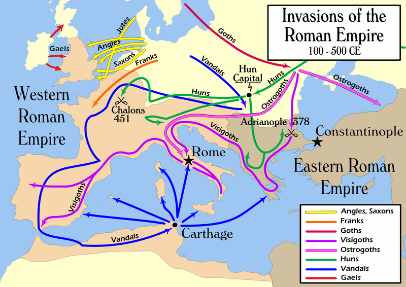
English: Map of the "barbarian" invasions by the Angles, Saxons, Jutes, Franks, Goths, Visigoths, Ostrogoths, Huns and Vandals of the Roman Empire showing the major incursions from 100 to 500 CE.
|
|||
| កាលបរិច្ឆេទ | ||||
| ប្រភព | ការងារផ្ទាល់របស់អ្នកផ្ទុកឡើង | |||
| អ្នកនិពន្ធ | User:MapMaster | |||
| ទំរង់ផ្សេងទៀត |
[]
|


ការដាក់អាជ្ញាប័ណ្ណ
I, the copyright holder of this work, hereby publish it under the following license:
ឯកសារនេះជាប់អាជ្ញាបណ្ឌCreative Commons Attribution-Share Alike 2.5 Generic។
- អ្នកមានសិទ្ធិ៖
- ចែកចាយ – ថតចំលងនិងចែកចាយស្នាដៃនេះ
- កែច្នៃ – កែច្នៃយកទៅប្រើ
- ក្រោមលក្ខខណ្ឌដូចតទៅនេះ៖
- ភាពជាម្ចាស់កម្មសិទ្ធ – You must give appropriate credit, provide a link to the license, and indicate if changes were made. You may do so in any reasonable manner, but not in any way that suggests the licensor endorses you or your use.
- share alike – If you remix, transform, or build upon the material, you must distribute your contributions under the same or compatible license as the original.
ប្រវត្តិឯកសារ
ចុចលើម៉ោងនិងកាលបរិច្ឆេទដើម្បីមើលឯកសារដែលបានផ្ទុកឡើងនៅពេលនោះ។
| ម៉ោងនិងកាលបរិច្ឆេទ | កូនរូបភាព | វិមាត្រ | អ្នកប្រើប្រាស់ | យោបល់ | |
|---|---|---|---|---|---|
| បច្ចុប្បន្ន | ម៉ោង២១:០៨ ថ្ងៃច័ន្ទ ទី១៤ ខែកុម្ភៈ ឆ្នាំ២០២២ | | ១៩៥៤ × ១៣៨២ (២៦៩គីឡូបៃ) | SKIBLY101 | add the scotti |
| ម៉ោង០៣:៣៦ ថ្ងៃអាទិត្យ ទី០៩ ខែមករា ឆ្នាំ២០២២ |  | ១៩៥៤ × ១៣៦២ (១២៧គីឡូបៃ) | Jul059 | Lossless file size reduction | |
| ម៉ោង១៦:០៧ ថ្ងៃពុធ ទី២៦ ខែកុម្ភៈ ឆ្នាំ២០១៤ |  | ១៩៥៤ × ១៣៦២ (១៣៩គីឡូបៃ) | Capmo | cropped very minor white margin | |
| ម៉ោង០៨:៣៥ ថ្ងៃអង្គារ ទី១៧ ខែកក្កដា ឆ្នាំ២០០៧ |  | ១៩៦២ × ១៣៧៤ (១៣៩គីឡូបៃ) | Nihad Hamzic | Removed alpha channel, what enabled me to losslessly reduce color domain to 8-bit. The result is a much, much smaller file. If alpha channel is indeed needed, then just revert the actual image to the one which I had previously uploaded (around 480 KB). | |
| ម៉ោង១០:៤៨ ថ្ងៃច័ន្ទ ទី១៦ ខែកក្កដា ឆ្នាំ២០០៧ |  | ១៩៦២ × ១៣៧៤ (៤៨៨គីឡូបៃ) | Nihad Hamzic | Further reduced image size by losslessly optimising PNG compression type. This image's color domain could be reduced to 8-bit if alpha channel was removed, resulting in enormous image size reducion. Is alpha channel really needed here? | |
| ម៉ោង១៩:២៧ ថ្ងៃអង្គារ ទី៣១ ខែតុលា ឆ្នាំ២០០៦ |  | ១៩៦២ × ១៣៧៤ (៦២៤គីឡូបៃ) | MapMaster | Smaller, with some corrections and improvements | |
| ម៉ោង១៥:១៧ ថ្ងៃសៅរ៍ ទី២១ ខែតុលា ឆ្នាំ២០០៦ |  | ១៩៥៩ × ១៣៩៨ (៦០៣គីឡូបៃ) | MapMaster | Improved version | |
| ម៉ោង២១:៣៥ ថ្ងៃព្រហស្បតិ៍ ទី១៩ ខែតុលា ឆ្នាំ២០០៦ |  | ១៩៦១ × ១៤០៥ (៦០២គីឡូបៃ) | MapMaster | I corrected the "Huns" route on this map, and am attempting to uploaded a 50% smaller version (Kbyte-wise). | |
| ម៉ោង០១:៣៥ ថ្ងៃច័ន្ទ ទី០២ ខែតុលា ឆ្នាំ២០០៦ |  | ៣៩៤៨ × ២៨២៧ (១.២៨មេកាបៃ) | MapMaster | uploaded improved map | |
| ម៉ោង១៨:២៧ ថ្ងៃអាទិត្យ ទី០១ ខែតុលា ឆ្នាំ២០០៦ |  | ៣៩៤៤ × ២៨១៤ (១.០៤មេកាបៃ) | MapMaster | Map of the "barbarian" invasions of the Roman Empire |
បម្រើបម្រាស់ឯកសារ
ទំព័រ ខាងក្រោមប្រើប្រាស់ឯកសារនេះ ៖
បម្រើបម្រាស់ឯកសារជាសាកល
វីគីដទៃទៀតដូចខាងក្រោមនេះប្រើប្រាស់ឯកសារនេះ៖
- ការប្រើប្រាស់នៅក្នុង ar.wikipedia.org
- ការប្រើប្រាស់នៅក្នុង azb.wikipedia.org
- ការប្រើប្រាស់នៅក្នុង az.wikipedia.org
- ការប្រើប្រាស់នៅក្នុង ba.wikipedia.org
- ការប្រើប្រាស់នៅក្នុង be-tarask.wikipedia.org
- ការប្រើប្រាស់នៅក្នុង be.wikipedia.org
- ការប្រើប្រាស់នៅក្នុង bg.wikipedia.org
- ការប្រើប្រាស់នៅក្នុង ckb.wikipedia.org
- ការប្រើប្រាស់នៅក្នុង csb.wikipedia.org
- ការប្រើប្រាស់នៅក្នុង cs.wikipedia.org
- ការប្រើប្រាស់នៅក្នុង da.wikipedia.org
- ការប្រើប្រាស់នៅក្នុង de.wikipedia.org
- ការប្រើប្រាស់នៅក្នុង de.wikibooks.org
- ការប្រើប្រាស់នៅក្នុង diq.wikipedia.org
- ការប្រើប្រាស់នៅក្នុង el.wikipedia.org
- ការប្រើប្រាស់នៅក្នុង en.wikipedia.org
- Civilization
- Germanic peoples
- History of Europe
- Ostrogoths
- Roman Empire
- History of Austria
- History of Bulgaria
- History of Tunisia
- Ancient history
- Migration Period
- Barbarian
- Seeress (Germanic)
- Western Roman Empire
- Ancient Rome
- Early Middle Ages
- Fall of the Western Roman Empire
- Talk:Attila/Archive 2
- Chernyakhov culture
- Roman Gaul
View more global usage of this file.