
ឯកសារ:Mapofkanto.png
គ្មានភាពម៉ត់ខ្ពស់ជាងនេះទេ។
Mapofkanto.png (៥៨៥ × ៥៥៤ ភីកសែល ទំហំឯកសារ៖ ៣០៦គីឡូបៃ ប្រភេទ MIME៖ image/png)
ចំណារពន្យល់
| ការពិពណ៌នា |
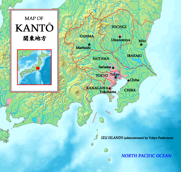
English: A map of the Kanto region in Japan with prefectures and their borders indicated. Made by the uploader. Map is based on a map taken from http://www.demis.nl/wms/mapclip.htm.
日本語: 関東地方の地図、http://www.demis.nl/wms/mapclip.htmから。 |
| កាលបរិច្ឆេទ | ១ ខែកក្កដា ២០០៦ (original upload date) |
| ប្រភព | Made by the uploader. Map is based on a map taken from http://www.demis.nl/wms/mapclip.htm. |
| អ្នកនិពន្ធ | No machine-readable author provided. Tonym88~commonswiki assumed (based on copyright claims). |
ការដាក់អាជ្ញាប័ណ្ណ
I, the copyright holder of this work, hereby publish it under the following licenses:

|
រូបភាពនៃទំព័រនេះជាកម្មសិទ្ធិរបស់GNU Free Documentation License។ Version 1.2 ឬក៏ខ្ពស់ជាងនេះត្រូវបានឧបត្ថមគាំទ្រដោយ មូលនិធិសូហ្វវែរដោយឥតគិតថ្លៃ (Free Software Foundation) ដែលមិនមានផ្នែកណាមួយរបស់ប្រភពដើមរួមទាំងអក្សរនៅលើគំរបមុខនិងខ្នង ត្រូវបានផ្លាស់ប្តូរទេ។ ចំពោះផ្នែកដែលមិនអាចផ្លាស់ប្តូរបាន សូមមើលGNU Free Documentation License។ |
| ឯកសារនេះជាប់អាជ្ញាបណ្ឌCreative Commons Attribution-Share Alike 3.0 Unported។ | ||
| ||
| This licensing tag was added to this file as part of the GFDL licensing update. |
ឯកសារនេះជាប់អាជ្ញាបណ្ឌCreative Commons Attribution-Share Alike 2.5 Generic, 2.0 Generic និង 1.0 Generic។
- អ្នកមានសិទ្ធិ៖
- ចែកចាយ – ថតចំលងនិងចែកចាយស្នាដៃនេះ
- កែច្នៃ – កែច្នៃយកទៅប្រើ
- ក្រោមលក្ខខណ្ឌដូចតទៅនេះ៖
- ភាពជាម្ចាស់កម្មសិទ្ធ – You must give appropriate credit, provide a link to the license, and indicate if changes were made. You may do so in any reasonable manner, but not in any way that suggests the licensor endorses you or your use.
- share alike – If you remix, transform, or build upon the material, you must distribute your contributions under the same or compatible license as the original.
You may select the license of your choice.
This image is in the public domain because it came from the site https://www.demis.nl/products/web-map-server/examples/ and was released by the copyright holder. Permission is granted to copy, distribute and/or modify this map since it is based on free of copyright images from: www.demis.nl. See also approval email on de.wp and its clarification.
|
| This work has been released into the public domain by its copyright holder, www.demis.nl. This applies worldwide. In some countries this may not be legally possible; if so: www.demis.nl grants anyone the right to use this work for any purpose, without any conditions, unless such conditions are required by law.
|
ប្រវត្តិឯកសារ
ចុចលើម៉ោងនិងកាលបរិច្ឆេទដើម្បីមើលឯកសារដែលបានផ្ទុកឡើងនៅពេលនោះ។
| ម៉ោងនិងកាលបរិច្ឆេទ | កូនរូបភាព | វិមាត្រ | អ្នកប្រើប្រាស់ | យោបល់ | |
|---|---|---|---|---|---|
| បច្ចុប្បន្ន | ម៉ោង១៨:៣៩ ថ្ងៃសៅរ៍ ទី១៩ ខែឧសភា ឆ្នាំ២០០៧ | | ៥៨៥ × ៥៥៤ (៣០៦គីឡូបៃ) | Tonym88~commonswiki | New version |
| ម៉ោង២០:២៤ ថ្ងៃសៅរ៍ ទី០១ ខែកក្កដា ឆ្នាំ២០០៦ |  | ៦២៧ × ៥៨១ (២៧៩គីឡូបៃ) | Tonym88~commonswiki | A map of the Kanto region in Japan with Prefectures and their borders indicated. Made by the uploader. Map is based on a map taken from http://www.demis.nl/wms/mapclip.htm. This is a duplicate image of Image:Kantomap.png. This image had to be create |
បម្រើបម្រាស់ឯកសារ
ទំព័រ ខាងក្រោមប្រើប្រាស់ឯកសារនេះ ៖
បម្រើបម្រាស់ឯកសារជាសាកល
វីគីដទៃទៀតដូចខាងក្រោមនេះប្រើប្រាស់ឯកសារនេះ៖
- ការប្រើប្រាស់នៅក្នុង arz.wikipedia.org
- ការប្រើប្រាស់នៅក្នុង azb.wikipedia.org
- ការប្រើប្រាស់នៅក្នុង be.wikipedia.org
- ការប្រើប្រាស់នៅក្នុង en.wikipedia.org
- ការប្រើប្រាស់នៅក្នុង es.wikipedia.org
- ការប្រើប្រាស់នៅក្នុង fa.wikipedia.org
- ការប្រើប្រាស់នៅក្នុង fr.wikipedia.org
- ការប្រើប្រាស់នៅក្នុង gl.wikipedia.org
- ការប្រើប្រាស់នៅក្នុង hu.wikipedia.org
- ការប្រើប្រាស់នៅក្នុង io.wikipedia.org
- ការប្រើប្រាស់នៅក្នុង nl.wikipedia.org
- ការប្រើប្រាស់នៅក្នុង nn.wikipedia.org
- ការប្រើប្រាស់នៅក្នុង pam.wikipedia.org
- ការប្រើប្រាស់នៅក្នុង pl.wikipedia.org
- ការប្រើប្រាស់នៅក្នុង pt.wikipedia.org
- ការប្រើប្រាស់នៅក្នុង ru.wikipedia.org
- ការប្រើប្រាស់នៅក្នុង sco.wikipedia.org
- ការប្រើប្រាស់នៅក្នុង simple.wikipedia.org
- ការប្រើប្រាស់នៅក្នុង sr.wikipedia.org
- ការប្រើប្រាស់នៅក្នុង th.wikipedia.org
- ការប្រើប្រាស់នៅក្នុង ur.wikipedia.org
- ការប្រើប្រាស់នៅក្នុង vi.wikipedia.org