
ឯកសារ:Qing Empire circa 1820 EN.svg

Size of this PNG preview of this SVG file: ៦៨៦ × ៦០០ ភីកសែ. ភាពម៉ត់ផ្សេងទៀត៖ ២៧៥ × ២៤០ ភីកសែ | ៥៤៩ × ៤៨០ ភីកសែ | ៨៧៩ × ៧៦៨ ភីកសែ | ១១៧២ × ១០២៤ ភីកសែ | ២៣៤៣ × ២០៤៨ ភីកសែ | ៨៤៩ × ៧៤២ ភីកសែ។
រូបភាពដើម (ឯកសារប្រភេទSVG ៨៤៩ × ៧៤២ ភីកសែល ទំហំឯកសារ៖ ៥៤៨គីឡូបៃ)

|
This file requires updating because: The island of Sumatra as depicted on the small globe in the lower left is colliding with Atlantis (Tuva?) and a peninsula unknown to modern geography is extending off the western coast of India. The eastern coast of Taiwan was never under the sovereignty of the Qing Empire. In doing so, you could add a timestamp to the file.
|
ចំណារពន្យល់
| ការពិពណ៌នា |
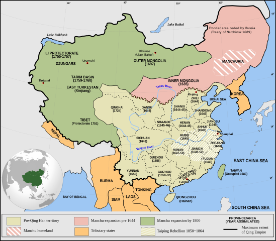
English: Qing Empire c. 1820 |
| កាលបរិច្ឆេទ | |
| ប្រភព | ការងារផ្ទាល់របស់អ្នកផ្ទុកឡើង Incorporates modified version of File:Empire of the Great Qing (orthographic projection).svg. Note that the map excludes Tawang from Tibet. |
| អ្នកនិពន្ធ | Philg88: Attribution Wikimedia Foundation, www.wikimedia.org |
.svg)
ការដាក់អាជ្ញាប័ណ្ណ
This file is licensed under the Creative Commons Attribution 4.0 International license.
- អ្នកមានសិទ្ធិ៖
- ចែកចាយ – ថតចំលងនិងចែកចាយស្នាដៃនេះ
- កែច្នៃ – កែច្នៃយកទៅប្រើ
- ក្រោមលក្ខខណ្ឌដូចតទៅនេះ៖
- ភាពជាម្ចាស់កម្មសិទ្ធ – You must give appropriate credit, provide a link to the license, and indicate if changes were made. You may do so in any reasonable manner, but not in any way that suggests the licensor endorses you or your use.
ប្រវត្តិឯកសារ
ចុចលើម៉ោងនិងកាលបរិច្ឆេទដើម្បីមើលឯកសារដែលបានផ្ទុកឡើងនៅពេលនោះ។
| ម៉ោងនិងកាលបរិច្ឆេទ | កូនរូបភាព | វិមាត្រ | អ្នកប្រើប្រាស់ | យោបល់ | |
|---|---|---|---|---|---|
| បច្ចុប្បន្ន | ម៉ោង២០:០៣ ថ្ងៃអាទិត្យ ទី១៣ ខែមិថុនា ឆ្នាំ២០២១ | | ៨៤៩ × ៧៤២ (៥៤៨គីឡូបៃ) | SSH remoteserver | Reverted to version as of 03:34, 13 June 2021 (UTC) |
| ម៉ោង១៨:៣១ ថ្ងៃអាទិត្យ ទី១៣ ខែមិថុនា ឆ្នាំ២០២១ |  | ៨៤៩ × ៧៤២ (៥៤៨គីឡូបៃ) | SSH remoteserver | Reverted to version as of 00:04, 13 June 2021 (UTC) | |
| ម៉ោង០៣:៣៤ ថ្ងៃអាទិត្យ ទី១៣ ខែមិថុនា ឆ្នាំ២០២១ |  | ៨៤៩ × ៧៤២ (៥៤៨គីឡូបៃ) | NorthTension | Reverted to version as of 07:44, 15 December 2020 (UTC) | |
| ម៉ោង០០:០៤ ថ្ងៃអាទិត្យ ទី១៣ ខែមិថុនា ឆ្នាំ២០២១ |  | ៨៤៩ × ៧៤២ (៥៤៨គីឡូបៃ) | SSH remoteserver | Burma was not a tributary. Please See: A Disguised Defeat https://www.jstor.org/stable/3876499; and Burmese Chronicles | |
| ម៉ោង០៧:៤៤ ថ្ងៃអង្គារ ទី១៥ ខែធ្នូ ឆ្នាំ២០២០ |  | ៨៤៩ × ៧៤២ (៥៤៨គីឡូបៃ) | LiliCharlie | Reverted to version as of 21:26, 10 October 2020 (UTC) — that's an embedded bitmap rather than a vector image — as Bidgee said, if you dispute it, upload under a new file name, perhaps as a PNG file | |
| ម៉ោង០៧:១៣ ថ្ងៃអង្គារ ទី១៥ ខែធ្នូ ឆ្នាំ២០២០ |  | ១១៧២ × ១០២៤ (៥០៩គីឡូបៃ) | Бмхүн | Reverted to version as of 10:04, 24 March 2020 (UTC) | |
| ម៉ោង២១:២៦ ថ្ងៃសៅរ៍ ទី១០ ខែតុលា ឆ្នាំ២០២០ |  | ៨៤៩ × ៧៤២ (៥៤៨គីឡូបៃ) | Bidgee | Reverted to version as of 16:15, 29 April 2014 (UTC) if you dispute it, upload under a new file per COM:OVERWRITE | |
| ម៉ោង១១:០០ ថ្ងៃអាទិត្យ ទី០៤ ខែតុលា ឆ្នាំ២០២០ |  | ១១៧២ × ១០២៤ (៥០៩គីឡូបៃ) | Бмхүн | The oldest version has too much wrong,such as Guizhou should be Guangxi, Caton isn’t Guangdong, and manchus homeland located in south part of Manchuria | |
| ម៉ោង១៦:៥៤ ថ្ងៃអង្គារ ទី២៣ ខែមិថុនា ឆ្នាំ២០២០ |  | ៨៤៩ × ៧៤២ (៥៤៨គីឡូបៃ) | LiliCharlie | Reverted embedded bitmap version to true vector version as of 16:15, 29 April 2014 (UTC) | |
| ម៉ោង១០:០៤ ថ្ងៃអង្គារ ទី២៤ ខែមីនា ឆ្នាំ២០២០ |  | ១១៧២ × ១០២៤ (៥០៩គីឡូបៃ) | Anchuhu | Reverted to version as of 06:35, 9 January 2019 (UTC) the borders and provinces name are wrong |
បម្រើបម្រាស់ឯកសារ
ទំព័រ ខាងក្រោមប្រើប្រាស់ឯកសារនេះ ៖
បម្រើបម្រាស់ឯកសារជាសាកល
វីគីដទៃទៀតដូចខាងក្រោមនេះប្រើប្រាស់ឯកសារនេះ៖
- ការប្រើប្រាស់នៅក្នុង ar.wikipedia.org
- ការប្រើប្រាស់នៅក្នុង cdo.wikipedia.org
- ការប្រើប្រាស់នៅក្នុង cs.wikipedia.org
- ការប្រើប្រាស់នៅក្នុង da.wikipedia.org
- ការប្រើប្រាស់នៅក្នុង de.wikipedia.org
- ការប្រើប្រាស់នៅក្នុង el.wikipedia.org
- ការប្រើប្រាស់នៅក្នុង en.wikipedia.org
- China
- History of China
- History of Asia
- Imperialism
- History of East Asia
- Taiping Rebellion
- Manchu people
- History of Tibet
- Treaty of Nerchinsk
- Portal:Asia
- History of Mongolia
- Amur Annexation
- Transition from Ming to Qing
- Settler colonialism
- Talk:Qing dynasty/Archive 5
- Tibet under Qing rule
- Xinjiang under Qing rule
- List of modern great powers
- Timeline of the Qing dynasty
- User:Falcaorib
- Talk:COVID-19 pandemic/Archive 2
- User talk:FuzionEXA
- User:Sanskar shingare/sandbox
- ការប្រើប្រាស់នៅក្នុង es.wikipedia.org
- ការប្រើប្រាស់នៅក្នុង et.wikipedia.org
- ការប្រើប្រាស់នៅក្នុង fa.wikipedia.org
- ការប្រើប្រាស់នៅក្នុង fr.wikipedia.org
View more global usage of this file.