
ឯកសារ:Sumatra Topography.png

ទំហំរបស់ការមើលមុននេះ: ៥៩១ × ៥៩៩ ភីកសែ។ ភាពម៉ត់ផ្សេងទៀត៖ ២៣៧ × ២៤០ ភីកសែ | ៤៧៣ × ៤៨០ ភីកសែ | ៧៥៧ × ៧៦៨ ភីកសែ | ១០១០ × ១០២៤ ភីកសែ | ២០៨០ × ២១០៩ ភីកសែ។
រូបភាពដើម (២០៨០ × ២១០៩ ភីកសែល ទំហំឯកសារ៖ ២.១៧មេកាបៃ ប្រភេទ MIME៖ image/png)
ចំណារពន្យល់
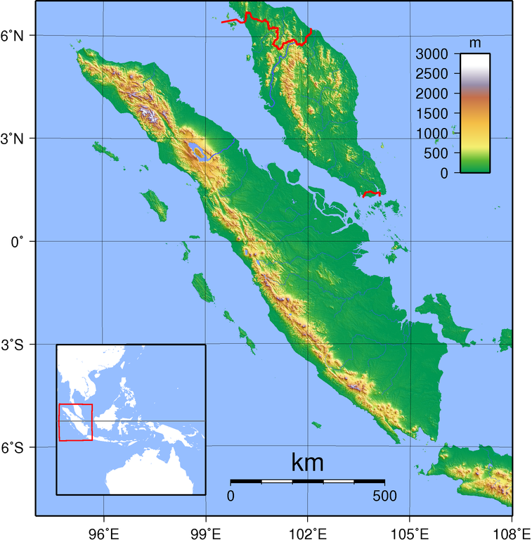
| ការពិពណ៌នា | Topographic map of Sumatra. Created with GMT from publicly released SRTM data. For locator vesion, see Image:Sumatra Locator Topography.png |
| កាលបរិច្ឆេទ | |
| ប្រភព | ការងារផ្ទាល់របស់អ្នកផ្ទុកឡើង |
| អ្នកនិពន្ធ | Sadalmelik |
ការដាក់អាជ្ញាប័ណ្ណ
I, the copyright holder of this work, hereby publish it under the following licenses:

|
រូបភាពនៃទំព័រនេះជាកម្មសិទ្ធិរបស់GNU Free Documentation License។ Version 1.2 ឬក៏ខ្ពស់ជាងនេះត្រូវបានឧបត្ថមគាំទ្រដោយ មូលនិធិសូហ្វវែរដោយឥតគិតថ្លៃ (Free Software Foundation) ដែលមិនមានផ្នែកណាមួយរបស់ប្រភពដើមរួមទាំងអក្សរនៅលើគំរបមុខនិងខ្នង ត្រូវបានផ្លាស់ប្តូរទេ។ ចំពោះផ្នែកដែលមិនអាចផ្លាស់ប្តូរបាន សូមមើលGNU Free Documentation License។ |
ឯកសារនេះជាប់អាជ្ញាបណ្ឌCreative Commons Attribution-Share Alike 3.0 Unported, 2.5 Generic, 2.0 Generic និង 1.0 Generic។
- អ្នកមានសិទ្ធិ៖
- ចែកចាយ – ថតចំលងនិងចែកចាយស្នាដៃនេះ
- កែច្នៃ – កែច្នៃយកទៅប្រើ
- ក្រោមលក្ខខណ្ឌដូចតទៅនេះ៖
- ភាពជាម្ចាស់កម្មសិទ្ធ – You must give appropriate credit, provide a link to the license, and indicate if changes were made. You may do so in any reasonable manner, but not in any way that suggests the licensor endorses you or your use.
- share alike – If you remix, transform, or build upon the material, you must distribute your contributions under the same or compatible license as the original.
You may select the license of your choice.
ប្រវត្តិឯកសារ
ចុចលើម៉ោងនិងកាលបរិច្ឆេទដើម្បីមើលឯកសារដែលបានផ្ទុកឡើងនៅពេលនោះ។
| ម៉ោងនិងកាលបរិច្ឆេទ | កូនរូបភាព | វិមាត្រ | អ្នកប្រើប្រាស់ | យោបល់ | |
|---|---|---|---|---|---|
| បច្ចុប្បន្ន | ម៉ោង១៨:៥១ ថ្ងៃសៅរ៍ ទី០១ ខែកញ្ញា ឆ្នាំ២០០៧ | | ២០៨០ × ២១០៩ (២.១៧មេកាបៃ) | Sadalmelik | {{Information |Description=Topographic map of Sumatra. Created with GMT from publicly released SRTM data. For locator vesion, see Image:Sumatra Locator Topography.png |Source=self-made |Date=Sep 1, 2007 |Author= Sadalmelik }} [[C |
បម្រើបម្រាស់ឯកសារ
ទំព័រ ខាងក្រោមប្រើប្រាស់ឯកសារនេះ ៖
បម្រើបម្រាស់ឯកសារជាសាកល
វីគីដទៃទៀតដូចខាងក្រោមនេះប្រើប្រាស់ឯកសារនេះ៖
- ការប្រើប្រាស់នៅក្នុង ace.wikipedia.org
- Gunong Bandahara
- Gunong Geureudông
- Gunong Ulu Masén
- Ruja
- Gunong Kulu
- Gunong Leuser
- Samalanga
- Gunong Sejuk (4,10°LU 96,84°BT)
- Gunong Keumiri
- Gunong Karang Putih
- Bur Karang Putih
- Gunong Lembu
- Gunong Loser
- Gunong Abông-abông
- Gunong Anu
- Gunong Bipak Tiga
- Gunong Gemiring
- Bur Berawang Naru
- Gunong Peuet Sago
- Gunong Kemiki
- Burni Seunangan
- Bur Pangwa
- Gunong Bipak Dua
- Gunong Pungongesong
- Burni Jamur Simpang Dua
- Burni Pucôk Bunge Tali
- Bur Blang Beke
- Burni Jamur Pisang
- Gunong Kapal
- Burni Pucôk Lumut
- Burni Bekulah
- Gunong Burniklieuteun
- Burni Simpang Tiga
- Bur Tetinggi
- Gunong Pucôk Padang
- Gunong Aber
- Burni Sejuk
- Bur Pantan Dedalu
- Burni Pucôk Jagong
- Bur Gajah
- Bur Senubung
- Gunong Bermumu
- Gunong Lojang
- Gunong Mas-mas
- Bur Niatumedulang
- Burni Kemiri
- Burni Pasir Putih (4,28°LU 96,80°BT)
- Gunong Padang Sri Bulen
- Burni Simpang Dua Kuen
- Burni Simpang Dua Gemboyah
View more global usage of this file.